Canning Highway

Last updated

Canning Highway

Canning Highway, Applecross.jpg
Canning Highway running through Applecross
Canning Highway
General information
TypeHighway
Length17 km (11 mi)
Opened1920s
Route number(s)
Major junctions
Northeast endAustralian national highway 94.svgAustralian national route 1.svg Great Eastern Highway (National Highway 94 / National Route 1), Victoria Park
 
Southwest endAustralian state route 12.svg Queen Victoria Street (State Route 12), Fremantle
Location(s)
Major settlements South Perth, Kensington, Como, Applecross , East Fremantle
Highway system

Canning Highway is an arterial road in Perth, Western Australia, linking the inner Perth suburb of Victoria Park in the north-east, to the port city of Fremantle in the south-west.

Contents

The road is mostly a four-lane divided carriageway, with a general speed limit of 60 km/h (37 mph). It is located immediately south of the Swan River and runs between The Causeway in Victoria Park and Queen Victoria Street in Fremantle.

The Canning Highway was the inspiration for the AC/DC song "Highway to Hell" as it had a reputation for accidents and led to many of singer Bon Scott's favourite pubs and hotels, including the Raffles Hotel. [1] [2]

History

Canning Highway is named after the river which it crosses, [3] which was in turn named after George Canning (1770–1827), an eminent British statesman who for a brief period was Prime Minister of Great Britain.

The modern highway was formally commenced in the 1920s, with major work commencing in 1927 to upgrade an 8-mile (13 km) section between Suburban Street, South Perth (now Mill Point Road) and Petra Street, East Fremantle. The road initially had the following names: [4]

Canning Bridge Canning bridge wa gnangarra.jpg
Canning Bridge

The road was officially named Canning Highway on 23 November 1937. [4] In 1938, the present northern bridge over Canning River was opened. It was 32 feet (9.8 m) wide and constructed of timber, as was then common practice. The experience gained building this bridge was used to construct the Fremantle Traffic Bridge over the Swan River one year later. The Fremantle Traffic Bridge joined Canning Highway near Fremantle with North Fremantle, and this intersection forms the highway's present western terminus.

In 1958, the present southern bridge over Canning River was constructed which coincided with the opening of Kwinana Freeway between the Narrows Bridge and Canning Highway.

In 1974, the rotary (roundabout) at the southern end of the Causeway in Victoria Park was upgraded to a parclo interchange, which resulted in Canning Highway joining seamlessly with Great Eastern Highway. At the same time, Stirling Highway was extended from North Fremantle across the Swan River via the new Stirling bridge to join with Canning Highway.

In 1979, a new diamond interchange was built near Canning Bridge to route the Kwinana Freeway underneath Canning Highway and progress the freeway further southwards.

Apart from minor additional lanes and modifications, the highway has remained largely unchanged since.

Raffles Hotel

The Raffles Hotel Raffles 003.jpg
The Raffles Hotel

One of the most enduring sights on Canning Highway has been the Raffles Hotel at night-time, with its ornamental lighting and an iconic animated rooftop neon beer sign (for many years advertising Swan Lager). It is situated in Applecross adjacent to Canning Bridge. The hotel has reopened with a pub and a bottle shop called Raffles Liquor Merchants. The Raffles later swapped to two beer advertising neon lights, one for Victoria bitter and one large one advertising Crown lager. Since at least 2015 however, the neon lights now advertise Asahi Super Dry.

Public transport

Canning Highway crosses the Kwinana Freeway at the Canning Bridge station on the Mandurah railway line. Buses also stop at this station and enter and exit the freeway via bus lanes. High frequency route 910 traverses the whole length of Canning Highway, and route 111 also runs along the section of the highway west of Canning Bridge. Special event route 659 runs a limited stop route along Canning Highway between Fremantle Station and Perth Stadium.

Major intersections & interchanges

The entire highway is located in the Perth Metropolitan Region. All intersections mentioned below are signalised unless otherwise mentioned.

LGALocationkmmiDestinationsNotes
Victoria Park Burswood Victoria Park boundary0.000.00Australian national route 1.svgAustralian national highway 94.svgAustralian state route 5.svgAustralian state route 30.svg Great Eastern Highway northeast (National Route 1 / (National Highway 94) / The Causeway northwest (State Route 5) / Shepperton Road southeast (State Route 30) / Albany Highway southeast  Midland, Perth, Armadale Partially grade separated with no access into Albany Highway. Causeway to Canning Highway southbound is looped. Canning Highway northeast bound to Shepperton Road is at-grade; State Route 6 eastern terminus; National Route 1 continues southwest and northeast
Victoria Park 0.80.50Berwick Street  Bentley, St. James
South Perth South Perth 1.20.75Way RoadWay Road connects Canning Highway to Mill Point Road
2.01.2Douglas Avenue  Kensington, Bentley , Curtin University
South Perth Como boundary2.81.7South Terrace
Como 3.92.4Thelma Street (west)  South Perth / Barker Avenue (southeast)Thelma Street connects Canning Highway to Labouchere Road
5.03.1Henley Street  Manning, Karawara
5.53.4Australian national route 1.svgAustralian state route 2.svg Kwinana Freeway (State Route 2) southbound ramps  Rockingham / Australian state route 26.svg Manning Road (State Route 26) (east)  Manning, Salter Point Modified diamond interchange (Kwinana Freeway free flowing). National Route 1 western concurrency terminus; additional "bus-only" ramps to/from Perth; southbound entrance and Manning Road exit ramps merge, requiring weaving.
5.73.5Australian state route 2.svg Kwinana Freeway (State Route 2) northbound ramps  Perth, Joondalup / Australian state route 26.svg Manning Road (State Route 26) northbound rampSimilar to above, however there is no right turn availability from Canning Highway westbound to Kwinana Freeway northbound.
Canning River 5.8–
6.0
3.6–
3.7
Canning Bridge
Melville Applecross Mount Pleasant boundary6.13.8Canning Beach Road (north) / Kintail Road (west)No right turn access from Canning Beach/Kintail Road southbound onto Canning Highway westbound
6.64.1Sleat Road
Applecross 7.04.3Reynolds Road
Applecross Ardross boundary7.44.6Ardross Street
8.05.0Riseley Street  Booragoon
Alfred Cove Attadale boundary10.26.3 North Lake Road   Myaree, Kardinya, Cockburn Central
Attadale Bicton Melville Palmyra quadripoint 12.37.6 Stock Road   O'Connor, Rockingham
Bicton Palmyra boundary13.78.5Carrington Street  Hamilton Hill
Melville–East Fremantle Boundary Bicton East Fremantle Palmyra tripoint 14.08.7Petra Street
East Fremantle East Fremantle 15.29.4Preston Point Road
15.49.6Australian state route 5.svgAustralian Tourist Drive 204.svg Stirling Highway (State Route 5, Tourist Drive 204)  Mosman Park, Claremont, Perth
Fremantle Fremantle 16.110.0Australian state route 12.svg Queen Victoria Street (State Route 12)  North Fremantle, Cottesloe Highway terminus: continues west as Queen Victoria Street (State Route 12) to Fremantle CBD
1.000 mi = 1.609 km; 1.000 km = 0.621 mi

See also

Related Research Articles

<span class="mw-page-title-main">Swan River (Western Australia)</span> River in Perth, Western Australia

The Swan River is a major river in the southwest of Western Australia. The river runs through the metropolitan area of Perth, Western Australia's capital and largest city.

The Kwinana Freeway is a 72-kilometre (45 mi) freeway in and beyond the southern suburbs of Perth, Western Australia, linking central Perth with Mandurah to the south. It is the central section of State Route 2, which continues north as Mitchell Freeway to Clarkson, and south as Forrest Highway towards Bunbury. A 4-kilometre (2.5 mi) section between Canning and Leach highways is also part of National Route 1. Along its route are interchanges with several major roads, including Roe Highway and Mandjoogoordap Drive. The northern terminus of the Kwinana Freeway is at the Narrows Bridge, which crosses the Swan River, and the southern terminus is at Pinjarra Road, east of Mandurah.

<span class="mw-page-title-main">Graham Farmer Freeway</span> Freeway in Perth, Western Australia

Graham Farmer Freeway is a 6.4-kilometre (4.0 mi) inner-city freeway in Perth, Western Australia. It links Rivervale and Burswood with West Perth and Leederville, providing an east-west bypass of Perth's central business district.

<span class="mw-page-title-main">The Causeway</span> Road bridge in Perth, Western Australia

The Causeway is an arterial traffic crossing in Perth, Western Australia, linking the inner-city suburbs of East Perth and Victoria Park. It is carried over the Swan River at the eastern end of Perth Water by two bridges on either side of Heirisson Island. The current Causeway is the third structure to have been built across the river at this point.

<span class="mw-page-title-main">Roe Highway</span> Highway in Perth, Western Australia

Roe Highway is a 35-kilometre-long (22 mi) limited-access highway and partial freeway in Perth, Western Australia, linking Kewdale with the city's north-eastern and south-western suburbs. The northern terminus is at Reid Highway and Great Northern Highway in Middle Swan, and the southern terminus is with Murdoch Drive at the Kwinana Freeway interchange in Bibra Lake. Roe Highway, in addition to Reid Highway, form State Route 3, a partial ring road around the outer suburbs of the Perth metropolitan area. Roe Highway also forms part of National Highway 94 from Great Eastern Highway Bypass to Great Eastern Highway, and National Highway 95 from Great Eastern Highway to Great Northern Highway.

<span class="mw-page-title-main">Leach Highway</span> Highway in Perth, Western Australia

Leach Highway is a 23-kilometre (14 mi) east-west arterial highway in the southern suburbs of Perth, Western Australia, primarily linking Kewdale and Perth Airport with the city of Fremantle.

<span class="mw-page-title-main">Stirling Highway</span> Highway in Perth, Western Australia

Stirling Highway is, for most of its length, a four-lane single carriageway and major arterial road between Perth, Western Australia and the port city of Fremantle in Western Australia on the northern side of the Swan River. The speed limit is 60 km/h (37 mph). East of Crawley, it continues as Mounts Bay Road which links Crawley and the nearby University of Western Australia to the Perth central business district.

<span class="mw-page-title-main">Canning Bridge</span> Bridge in Perth, Western Australia

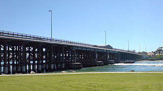
Canning Bridge is a traffic bridge which is the most downstream crossing of the Canning River in the city of Perth, Western Australia. The bridge is a part of Canning Highway, and it connects the suburbs of Como and Applecross. The Canning River is approximately 100 metres wide at the crossing, the narrowest point of the river along its downstream stretch. It is located near the Canning Bridge railway station.

<span class="mw-page-title-main">South Perth, Western Australia</span> Suburb of Perth, Western Australia

South Perth is a residential suburb of Perth, Western Australia that adjoins the southern shore of Perth Water on the Swan River; it is 3 kilometres (2 mi) south of the central business district. The suburb adjoins two major arterial roads—Canning Highway and the Kwinana Freeway, and is within the City of South Perth local government area.

<span class="mw-page-title-main">Victoria Park, Western Australia</span> Suburb of Perth, Western Australia

Victoria Park is an inner south eastern suburb of Perth, Western Australia. Its local government area is the Town of Victoria Park.

<span class="mw-page-title-main">William Street, Perth</span> Street in CBD Perth, Western Australia

William Street is a suburban distributor and one of two major cross-streets in the central business district of Perth, Western Australia. Commencing in western Mount Lawley, its route takes it through the Northbridge café and nightclub district as well as the CBD.

<span class="mw-page-title-main">Queen Victoria Street, Fremantle</span> Road in Fremantle, Western Australia

Queen Victoria Street is the main road entering the city centre of Fremantle, Western Australia from the direction of Perth. The road was originally named Cantonment Road, but was subsequently renamed Victoria Road, and a few years later Queen Victoria Street, after Queen Victoria of the United Kingdom, to avoid confusion with similarly named roads in the area.

Transport in Perth, Western Australia, is served by various means, among them an extensive highway / freeway network and a substantial system of commuter rail lines and bus routes. Public transport is managed by the Transperth agency.

Armadale Road is a major road in the south and south east of the Perth Metropolitan Area. It serves three purposes: firstly, providing a main route from Armadale to Fremantle; secondly, connecting Armadale to the Kwinana Freeway; and thirdly, since 2005, connecting it to the Tonkin Highway which ferries traffic to the eastern suburbs, Perth Airport and the Forrestfield and Kewdale industrial areas.

<span class="mw-page-title-main">Mounts Bay Road</span> Road in Perth, Western Australia

Mounts Bay Road is a major road in Perth, Western Australia, extending southwest from the central business district along the north bank of the Swan River, at the base of Kings Park.

<span class="mw-page-title-main">Raffles Hotel, Perth</span> Hotel in Applecross, Western Australia

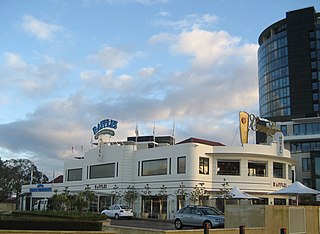
Raffles Hotel is located at the corner of Canning Highway and Canning Beach Road in the Perth, Western Australia suburb of Applecross, Western Australia. It is a two-storey hotel designed in the Inter-War Functionalist style and is one of the few examples of a hotel in this style surviving in the Perth metropolitan area. Earlier named the Canning Bridge Hotel, it has operated continuously as a licensed hotel since at least 1896. For over 50 years until 2002, it was owned by Australian nightclub owner and property developer Abe Saffron, whose plan to demolish the hotel was successfully opposed by the Art Deco Society of Western Australia in a ten-year campaign.

<span class="mw-page-title-main">Cycling in Perth</span>

Cycling in Perth, Western Australia is common on the roads and paths for recreation, commuting and sport. Between 1998 and 2009 the number of cyclists in Perth increased 450%.

<span class="mw-page-title-main">Riverside Drive, Perth</span> Road in Perth, Western Australia

Riverside Drive in Perth, Western Australia, is a road on the northern side of Perth Water. It was built on reclaimed land in the 1930s, and links The Causeway to the Narrows Bridge.

<span class="mw-page-title-main">South Street (Perth, Western Australia)</span> Road in Perth, Western Australia

South Street is an east-west arterial highway in the southern suburbs of Perth, Western Australia. It runs from Canning Vale to Fremantle, and is part of State Route 13.

References

  1. "AC/DC – The Stories Behind The Songs". NME. 28 January 2009. Retrieved 16 February 2020.
  2. Harmon, Steph (20 October 2019). "Highway to Hell: 10km of major Perth highway to shut for AC/DC covers concert". The Guardian. Retrieved 16 February 2020.
  3. "Origin and Meaning of Street and Place Names" (PDF). Municipal Heritage Inventory. City of South Perth. July 2004. p. 17. Archived from the original (PDF) on 27 March 2011. Retrieved 11 March 2013.
  4. 1 2 "The Land Act, 1933–1936. Change of Name of Road — Perth to Fremantle. (per 1495/30)". Western Australia Government Gazette. 23 November 1937. p. 1937:2009.
Template:Attached KML/Canning Highway
KML is from Wikidata