Hampton Road

Last updated

Hampton Road

Fremantle welcome - S Frem Hampton.jpg
Hampton Road at the southern end, looking north from the Rockingham Road and Cockburn Road intersection.
Hampton Road
General information
TypeRoad
Length2.9 km (1.8 mi)
Route number(s) Australian state route 12.svg State Route 12
Major junctions
North endAustralian state route 12.svg Ord Street (State Route 12), Fremantle
 
South endAustralian state route 12.svg Cockburn Road (State Route 12), South Fremantle
Location(s)
Major suburbs South Fremantle, Beaconsfield

Hampton Road is the main road entering the City of Fremantle from the south. It is named after John Stephen Hampton, the Governor of Western Australia from 1862 to 1868. [1] It continues into Ord Street at the north east corner of Fremantle Prison at Knutsford Street.

Heritage buildings and operations in historical properties occur along the length of the road; they include the Fremantle Children's Literature Centre, [2] Hampton Road reserve, [3] Bundi Kudja, [4] and St Pauls Anglican Church in Beaconsfield. [5] [6]

At the Cockburn Road and Rockingham Road intersection, which forms the southern terminus of the road, traffic bound for Fremantle arrives from Spearwood and Kwinana further south, and is brought through a high-density residential area, and past Fremantle Hospital and Fremantle Prison, two of Fremantle's landmarks.

Major intersections

All intersections below are controlled by traffic signals unless otherwise indicated.

LGALocationkmmiDestinationsNotes
Fremantle Fremantle 00.0Stirling Street northwest / Knutsford Street west  Fremantle, North Fremantle Un-signalised intersection, Knutsford Street is left-in only. Continues as Australian state route 12.svg Ord Street (State Route 12) north
10.62Western Australia MR-SM-1.svg Wray Avenue  Fremantle Access to Fremantle Hospital emergency entrance and the CBD from the south
FremantleBeaconsfieldSouth Fremantle tripoint 1.10.68Australian state route 13.svg South Street (State Route 13)  O'Connor, Kardinya, Murdoch, Canning Vale Access to Murdoch University
BeaconsfieldSouth Fremantle boundary1.60.99Lefroy Road  Hilton
2.31.4Douro Road  Fremantle Connects to southern end of Marine Terrace
2.61.6Clontarf Road  Hamilton Hill
FremantleCockburn boundary BeaconsfieldHamilton HillSouth Fremantle tripoint 2.81.7 Rockingham Road   Hamilton Hill, Spearwood, Kwinana Beach Continues south as Australian state route 12.svg Cockburn Road (State Route 12) to Coogee and Henderson Industrial Estate

Related Research Articles

<span class="mw-page-title-main">Great Eastern Highway</span> Highway in Western Australia

Great Eastern Highway is a 590-kilometre-long (370 mi) road that links the Western Australian capital of Perth with the city of Kalgoorlie. A key route for road vehicles accessing the eastern Wheatbelt and the Goldfields, it is the western portion of the main road link between Perth and the eastern states of Australia. The highway forms the majority of National Highway 94, although the alignment through the Perth suburbs of Guildford and Midland, and the eastern section between Coolgardie and Kalgoorlie are not included. Various segments form parts of other road routes, including National Route 1, Alternative National Route 94, and State Route 51.

<span class="mw-page-title-main">The Causeway</span> Road bridge in Perth, Western Australia

The Causeway is an arterial traffic crossing in Perth, Western Australia, linking the inner-city suburbs of East Perth and Victoria Park. It is carried over the Swan River at the eastern end of Perth Water by two bridges on either side of Heirisson Island. The current Causeway is the third structure to have been built across the river at this point.

<span class="mw-page-title-main">Barrack Street</span> Street in CBD of Perth, Western Australia

Barrack Street is one of two major cross-streets in the central business district of Perth, Western Australia. Together with St Georges Terrace, Wellington Street and William Street it defines the boundary of the main shopping precinct of the central city.

<span class="mw-page-title-main">Adelaide Terrace</span> Road in Perth, Western Australia

Adelaide Terrace is a major arterial road through the central business district of Perth, Western Australia. It runs parallel to the Swan River, linking St Georges Terrace with The Causeway.

<span class="mw-page-title-main">William Street, Perth</span> Street in CBD Perth, Western Australia

William Street is a suburban distributor and one of two major cross-streets in the central business district of Perth, Western Australia. Commencing in western Mount Lawley, its route takes it through the Northbridge café and nightclub district as well as the CBD.

<span class="mw-page-title-main">Queen Victoria Street, Fremantle</span> Road in Fremantle, Western Australia

Queen Victoria Street is the main road entering the city centre of Fremantle, Western Australia from the direction of Perth. The road was originally named Cantonment Road, but was subsequently renamed Victoria Road, and a few years later Queen Victoria Street, after Queen Victoria of the United Kingdom, to avoid confusion with similarly named roads in the area.

<span class="mw-page-title-main">High Street, Fremantle</span> Street in Fremantle, Western Australia

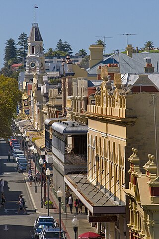
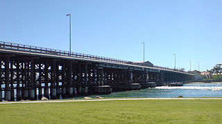
High Street is the main street running through the City of Fremantle, Western Australia. The street passes by historic landmarks, including the Round House, the Fremantle Town Hall, and the Fremantle War Memorial, through the Fremantle West End Heritage area and through two town squares. Trams operated along High Street for 47 years, between 1905 and 1952. Running east–west, High Street continues as Leach Highway, a major arterial road, at Stirling Highway, linking Fremantle with Perth Airport although the stretch of road between Stirling Highway and Carrington Street is known locally—and signed—as High Street.

<span class="mw-page-title-main">Marine Terrace, Fremantle</span> Street in Fremantle, Western Australia

Marine Terrace is a road on the southern side of the built up area of Fremantle, Western Australia. It is named for its location alongside the water front.

<span class="mw-page-title-main">Ellen Street, Fremantle</span> Street in Fremantle, Western Australia

Ellen Street is a parallel road to High Street in Fremantle, Western Australia. It was named after Ellen Stirling, wife of Governor Stirling.

<span class="mw-page-title-main">Adelaide Street, Fremantle</span> Street in Fremantle

Adelaide Street, Fremantle is a street that is a boundary for Kings Square, Fremantle in Western Australia. It goes north from Kings Square and meets Queen Victoria Street in a skewed junction that meets outside St Patrick's Basilica.

<span class="mw-page-title-main">Market Street, Fremantle</span> Street in Fremantle, Western Australia

Market Street, Fremantle is the location of the Fremantle Post Office in Fremantle, Western Australia.

<span class="mw-page-title-main">Parry Street, Fremantle</span> Street in Fremantle, Western Australia

Parry Street is a street in Fremantle, Western Australia.

<span class="mw-page-title-main">Mouat Street, Fremantle</span> Street in Fremantle, Western Australia

Mouat Street is a 300-metre-long (980 ft) street in Fremantle, Western Australia. Historically, the name was often spelled as Mouatt Street.

<span class="mw-page-title-main">Henry Street, Fremantle</span> Street in Fremantle, Western Australia

Henry Street is a 400-metre-long (1,300 ft) street in Fremantle, Western Australia. It was named after John Henry, second lieutenant of HMS Challenger. It was developed very early in the history of the Swan River Colony with licensed premises being located as early as 1833.

<span class="mw-page-title-main">Stirling Terrace, Toodyay</span> Street in Toodyay, Western Australia

Stirling Terrace is the main street of Toodyay, Western Australia, originally called New Road until 1905.

<span class="mw-page-title-main">Milligan Street, Perth</span> Road in Perth, Western Australia

Milligan Street is a street in Perth, Western Australia that runs from St Georges Terrace to north of Wellington Street. The northern section provides access to the Perth Arena carpark and Telethon Avenue; there are also dedicated Transperth bus roads connecting to the northern end, south of the Fremantle railway line.

Kenwick Link is a major road in Perth, Western Australia that bypasses Albany Highway in Beckenham and Kenwick. It is part of State Route 30, while the bypassed section of Albany Highway is allocated Alternate State Route 30. The road also provides access to Roe Highway, which does not connect to Albany Highway. It is a controlled-access road for its entire length, with a grade-separated interchange at Roe Highway, and at-grade intersections elsewhere, including traffic lights at Royal Street and both Albany Highway junctions. Main Roads Western Australia maintains and controls all of Kenwick Link, and uses the internal designation Highway H22 Wimbledon–Rupert Street Link.

<span class="mw-page-title-main">Pakenham Street, Fremantle</span> Street in Fremantle, Western Australia

Pakenham Street is a street in Fremantle, Western Australia, in the Fremantle West End Heritage area. It runs between Phillimore Street and Collie Street, the main cross intersection being with High Street.

Stephenson Avenue refers to two separate sections of road in the western suburbs of Perth, Western Australia.

References

  1. Ewers, John K. (1971). The Western Gateway: A History of Fremantle (2nd ed.). Nedlands, Western Australia: University of Western Australia Press for the Fremantle City Council. p. 223. ISBN   085564-050-2.
  2. "View archived webpage". Archived from the original on 18 September 2002.
  3. McIlroy, Jack; Building Management Authority of Western Australia (1990), Fremantle Prison : conservation and future use : historical and archaeological assessment of Hampton Road reserve and Henderson Street cottages, Building Management Authority of Western Australia, ISBN   978-0-7244-9672-3
  4. Heritage Council of Western Australia (1991), Report for Heritage Council of W.A. : Warick, 79 Solomon Street Fremantle; Atwell, 77 Solomon Street Fremantle; Bundi Kudja, 96 Hampton Road Fremantle, Heritage Council of Western Australia], retrieved 16 December 2016
  5. "CONCERT AT ST. PAULS HALL," BEACONSFIELD". The Daily News . Vol. XXVIII, no. 10, 758. Western Australia. 27 November 1909. p. 11. Retrieved 16 December 2016 via National Library of Australia.
  6. "ST. PAUL'S CHURCH, BEACONSFIELD". The West Australian . Vol. XX, no. 5, 667. Western Australia. 13 May 1904. p. 2. Retrieved 16 December 2016 via National Library of Australia.
Template:Attached KML/Hampton Road
KML is from Wikidata