
Fremantle is a port city in Western Australia located at the mouth of the Swan River in the metropolitan area of Perth, the state capital. Fremantle Harbour serves as the port of Perth. The Western Australian vernacular diminutive for Fremantle is Freo.

Rottnest Island, often colloquially referred to as "Rotto", is a 19-square-kilometre (7.3 sq mi) island off the coast of Western Australia, located 18 kilometres (11 mi) west of Fremantle. A sandy, low-lying island formed on a base of aeolianite limestone, Rottnest is an A-class reserve, the highest level of protection afforded to public land.

Fremantle Oval, also known by naming rights sponsorship as Fremantle Community Bank Oval, is a stadium in the centre of Fremantle, Western Australia, located on Parry Street. It currently has a capacity of 17,500 with terracing and a members area holding 750, though capacity was capped at 10,000 for Fremantle AFLW games. Fremantle Oval was originally used for cricket, but in 1895 hosted its first game of Australian rules football and Australian Football quickly became the main attraction leading to the development of the ground. It is located between the Fremantle Hospital, Fremantle Markets and the Fremantle Prison.
Bateman is a suburb of Perth, Western Australia, located within the City of Melville.

Canning Vale is a southern suburb of Perth, 22 km (13.7 mi) from the central business district. Its local government areas are the City of Canning and the City of Gosnells.

East Fremantle is a suburb of Perth, Western Australia, located 13 kilometres (8.1 mi) south-west of the central business district. The suburb is mainly residential, and is coterminous with the Town of East Fremantle local government area.
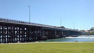
Queen Victoria Street is the main road entering the city centre of Fremantle, Western Australia, from the direction of Perth. The road was originally named Cantonment Road, but was subsequently renamed Victoria Road, and a few years later Queen Victoria Street, after Queen Victoria of the United Kingdom, to avoid confusion with similarly named roads in the area.

Hampton Road is the main road entering the City of Fremantle from the south. It is named after John Stephen Hampton, the Governor of Western Australia from 1862 to 1868. It continues into Ord Street at the north east corner of Fremantle Prison at Knutsford Street.
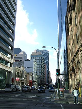
Waymouth Street, often spelt as Weymouth Street in the early days, is an east–west street running between King William Street and West Terrace in the Adelaide city centre in South Australia. The street is named after Henry Waymouth, a founding director of the South Australian Company, whose name was also sometimes spelt as Weymouth.
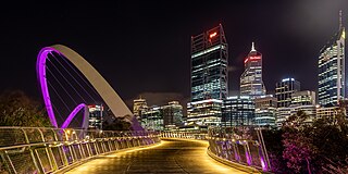
Tourism in Perth, the capital city of Western Australia, is an important part of the Australian state's economy, contributing to the prosperity of businesses in the city, as well as other regions of the state.
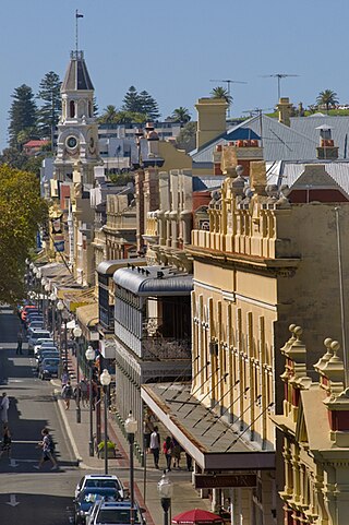
High Street is the main street running through the City of Fremantle, Western Australia. The street passes by historic landmarks, including the Round House, the Fremantle Town Hall, and the Fremantle War Memorial, through the Fremantle West End Heritage area and through two town squares. Trams operated along High Street for 47 years, between 1905 and 1952. Running east–west, High Street continues as Leach Highway, a major arterial road, at Stirling Highway, linking Fremantle with Perth Airport although the stretch of road between Stirling Highway and Carrington Street is known locally—and signed—as High Street.

Ellen Street is a parallel road to High Street in Fremantle, Western Australia. It was named after Ellen Stirling, wife of Governor Stirling.

South Terrace, Fremantle is a road in Fremantle, Western Australia that is renowned as the "Cappucino Strip" of Fremantle, due to the high number of coffee shops and restaurants.

Walyalup Koort, formerly known as Kings Square (or King's Square), is a town square in Fremantle, Western Australia. It is bounded by Queen, Newman, William, and Adelaide Streets. Though the square was originally a public reserve, it has been the site of Saint John's Church of England since 1843, and the Fremantle Town Hall since 1887. High Street was extended through and beyond the square in the 1880s, but the portion through the square was closed off in the 1960s. Today Kings Square functions as a civic and cultural centre of Fremantle, with modern events taking place adjacent to the historic buildings.

Adelaide Street, Fremantle is a street that is a boundary for Kings Square, Fremantle in Western Australia. It goes north from Kings Square and meets Queen Victoria Street in a skewed junction that meets outside St Patrick's Basilica.

Market Street, Fremantle is the location of the Fremantle Post Office in Fremantle, Western Australia.
Queens Square, also known as Queen's Square, is a town square in Fremantle, Western Australia. It is located at the intersection of High Street and Parry Street, both of which bisect the square. The square was originally a single space, but was divided into four sections due to the extensions of High and Parry Streets, completed in 1886. Today Queens Square still functions as a public open space for residents of Fremantle.

Mouat Street is a 300-metre-long (980 ft) street in Fremantle, Western Australia. Historically, the name was often spelled as Mouatt Street.

The architecture of Fremantle Prison includes the six-hectare (15-acre) site of the former prison on The Terrace, Fremantle, in Western Australia. Limestone was quarried on-site during construction, and the south-western corner and eastern portion of the site are at a considerably higher ground level. The Fremantle Prison site includes the prison cell blocks, gatehouse, perimeter walls, cottages, tunnels, and related infrastructure.

Pakenham Street is a street in Fremantle, Western Australia, in the Fremantle West End Heritage area. It runs between Phillimore Street and Collie Street, the main cross intersection being with High Street.

