Queen Victoria Street, Fremantle

Last updated

Queen Victoria Street

Historic Wooden Piling Bridge, Fremantle.jpg
Fremantle Traffic Bridge crossing the Swan River
Queen Victoria Street, Fremantle
General information
TypeRoad
Length2.0 km (1.2 mi)
Route number(s) Australian state route 12.svg State Route 12
Major junctions
North endAustralian state route 5.svg Stirling Highway (State Route 5), North Fremantle
 
South end Parry Street, Fremantle

Queen Victoria Street is the main road entering the city centre of Fremantle, Western Australia, from the direction of Perth. The road was originally named Cantonment Road, but was subsequently renamed Victoria Road, and a few years later Queen Victoria Street, after Queen Victoria of the United Kingdom, to avoid confusion with similarly named roads in the area. [1]

Contents

Due to its proximity to Fremantle Harbour it has at times had very heavy traffic. [2]

Route description

Northern terminus of Queen Victoria Street Northern end of Queen Victoria Street, branching off from Stirling Highway, December 2021 02.jpg
Northern terminus of Queen Victoria Street

The road's northern terminus, as well as that of State Route 12, is at a traffic light controlled Y Junction with Stirling Highway in North Fremantle . The next major intersection, 350 metres (1,150 ft) south, is with Tydeman Road, which leads to Fremantle Port to the west, and to the residential area of North Fremantle to the east. After another 400 metres (1,300 ft), the road reaches the Fremantle Traffic Bridge which crosses the Swan River. On the south side of the river, the road meets Canning Highway, and turns south-west towards the centre of Fremantle. After travelling 500 metres (1,600 ft) south-west, State Route 12 leaves Queen Victoria Street, heading down James Street towards Naval Base . The remaining 400 metres (1,300 ft) of Queen Victoria Street does not have a route allocation, and the road ends at its intersection with Parry Street. Adelaide Street continues south-west from that intersection, to High Street.

Crossing the Swan River

Driving from North Fremantle to Fremantle, crossing the Fremantle Traffic Bridge

In the 1830s ferries operated on the Swan River, including from North Fremantle [3] and from Preston Point, [4] [5] further up the river. The North Fremantle ferry only transported people and luggage, [3] whilst the Preston Point ferry also transported livestock. [3] [4]

There also existed a capstan, but only the base remains, which is known as the Ferry Capstan Base. [6] There is no clear evidence of the construction date or usage, [6] however there are accounts of it pulling a dredger and barges up the river, via a rope connected to a winch in the capstan. [6] [7] The accounts vary as to how it was powered, either by convicts [7] or animals pushing an iron bar to rotate the capstan, which was centred on a vertical axle. [6]

There have been four different bridges at this location since the 1860s, [8] the first of which was a timber bridge was constructed between 1863 and 1867, using convict labour. [8] [9] [10] The second bridge was constructed between 1896 and 1898 downstream of the existing bridge. [8] Whilst wider and stronger, it was only intended to be a temporary structure while the old bridge was removed and replaced. [8] However, no construction or demolition works occurred until 10 years later, with the old bridge left for pedestrians. [8] The third bridge was a renovation of the original bridge, which had its deck replaced, new support piles added, and existing piles modified. [8] The previous bridge was demolished after this bridge, which also catered for trams, was opened in 1909. [8] The current structure, which opened on 15 December 1939, was also only intended to be used for a few years, but has remained in service since then, with major strengthening and repair works carried out in 1978 and 1982. [8]

Street features

Victoria Avenue, North Fremantle, later renamed Queen Victoria Street. North Fremantle Town Hall is on the left. North Fremantle.jpg
Victoria Avenue, North Fremantle, later renamed Queen Victoria Street. North Fremantle Town Hall is on the left.

The street was the main street of the former Town of North Fremantle (1895–1961). The North Fremantle war memorial [11] and the former North Fremantle Town Hall are located on the street. [12]

Two bars are also located on the north side of the river along Queen Victoria Street: Mojo's Bar and the Swan Hotel, which has been on the street for over 100 years. [13]

In 2011, Queen Victoria Street underwent road works to improve traffic accommodation and the amenity of the area. [14]

Major intersections

Related Research Articles

<span class="mw-page-title-main">Swan River (Western Australia)</span> River in Perth, Western Australia

The Swan River is a major river in the southwest of Western Australia. The river runs through the metropolitan area of Perth, Western Australia's capital and largest city.

<span class="mw-page-title-main">Albany Highway</span> Highway in Western Australia

Albany Highway links Western Australia's capital city Perth with its oldest settlement, Albany, on the state's south coast. The 405-kilometre-long (252 mi) highway travels through the southern Wheatbelt and Great Southern regions, and is designated State Route 30 for most of its length. Outside of Perth the highway is predominately a sealed, single carriageway with regular overtaking lanes in some undulating areas. Albany Highway commences at The Causeway, a river crossing that connects to Perth's central business district. The highway heads south-east through Perth's metropolitan region, bypassed in part by Shepperton Road and Kenwick Link, and continues south-eastwards through to Albany. It intersects several major roads in Perth, including the Leach, Tonkin, Brookton, and South Western highways. The rural section of Albany Highway connects to important regional roads at the few towns and roadhouses along the route, including Coalfields Highway at Arthur River, Great Southern Highway at Cranbrook, and Muirs Highway at Mount Barker.

<span class="mw-page-title-main">Great Eastern Highway</span> Highway in Western Australia

Great Eastern Highway is a 590-kilometre-long (370 mi) road that links the Western Australian capital of Perth with the city of Kalgoorlie. A key route for road vehicles accessing the eastern Wheatbelt and the Goldfields, it is the western portion of the main road link between Perth and the eastern states of Australia. The highway forms the majority of National Highway 94, although the alignment through the Perth suburbs of Guildford and Midland, and the eastern section between Coolgardie and Kalgoorlie are not included. Various segments form parts of other road routes, including National Route 1, Alternative National Route 94, and State Route 51.

<span class="mw-page-title-main">Graham Farmer Freeway</span> Freeway in Perth, Western Australia

Graham Farmer Freeway is a 6.4-kilometre (4.0 mi) inner-city freeway in Perth, Western Australia. It links Rivervale and Burswood with West Perth and Leederville, providing an east-west bypass of Perth's central business district.

<span class="mw-page-title-main">North Fremantle, Western Australia</span> Town in Western Australia

North Fremantle is a suburb of Perth, Western Australia, located within the City of Fremantle, a local government area of the state. Its postcode is 6159.

<span class="mw-page-title-main">The Causeway</span> Road bridge in Perth, Western Australia

The Causeway is an arterial traffic crossing in Perth, Western Australia, linking the inner-city suburbs of East Perth and Victoria Park. It is carried over the Swan River at the eastern end of Perth Water by two bridges on either side of Heirisson Island. The current Causeway is the third structure to have been built across the river at this point.

<span class="mw-page-title-main">Canning Highway</span> Highway in Perth, Western Australia

Canning Highway is an arterial road in Perth, Western Australia, linking the inner Perth suburb of Victoria Park in the north-east, to the port city of Fremantle in the south-west.

<span class="mw-page-title-main">Leach Highway</span> Highway in Perth, Western Australia

Leach Highway is a 23-kilometre (14 mi) east-west arterial highway in the southern suburbs of Perth, Western Australia, primarily linking Kewdale and Perth Airport with the city of Fremantle.

<span class="mw-page-title-main">Stirling Highway</span> Highway in Perth, Western Australia

Stirling Highway is, for most of its length, a four-lane single carriageway and major arterial road between Perth, Western Australia and the port city of Fremantle in Western Australia on the northern side of the Swan River. The speed limit is 60 km/h (37 mph). East of Crawley, it continues as Mounts Bay Road which links Crawley and the nearby University of Western Australia to the Perth central business district.

Transport in Perth, Western Australia, is served by various means, among them an extensive highway / freeway network and a substantial system of commuter rail lines and bus routes. Public transport is managed by the Transperth agency.

<span class="mw-page-title-main">Mounts Bay Road</span> Road in Perth, Western Australia

Mounts Bay Road is a major road in Perth, Western Australia, extending southwest from the central business district along the north bank of the Swan River, at the base of Kings Park.

<span class="mw-page-title-main">Trams in Fremantle</span> Tram network in Fremantle, Western Australia

The Fremantle tramway network linked the central business district of Fremantle, the port city for Perth, Western Australia, with nearby suburbs. Small but comprehensive, it operated between 1905 and 1952. It was not connected with the larger Perth tramway system.

<span class="mw-page-title-main">Victoria Quay, Fremantle</span> Wharf on the south side of Fremantle Harbour, Western Australia

Victoria Quay is a wharf on the south bank of the Swan River mouth in the Western Australian port city of Fremantle. It is separated from the Fremantle CBD by the railway line. Originally named South Quay, it was renamed Victoria Quay on 26 July 1901 in honour of the late Queen Victoria. With North Quay it forms the Inner Harbour area of Fremantle Harbour.

<span class="mw-page-title-main">High Street, Fremantle</span> Street in Fremantle, Western Australia

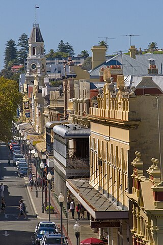
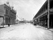
High Street is the main street running through the City of Fremantle, Western Australia. The street passes by historic landmarks, including the Round House, the Fremantle Town Hall, and the Fremantle War Memorial, through the Fremantle West End Heritage area and through two town squares. Trams operated along High Street for 47 years, between 1905 and 1952. Running east–west, High Street continues as Leach Highway, a major arterial road, at Stirling Highway, linking Fremantle with Perth Airport although the stretch of road between Stirling Highway and Carrington Street is known locally—and signed—as High Street.

<span class="mw-page-title-main">Queen Street, Fremantle</span> Street in Fremantle, Western Australia

Queen Street is a street in Fremantle, Western Australia that crosses High Street at Kings Square, and is located away from and west of Queens Square. It is a separate street from Queen Victoria Street, which is located 500 metres (0.3 mi) further north. The street is named after Queen Adelaide, consort of William IV.

<span class="mw-page-title-main">Fremantle Traffic Bridge</span> Bridge in Fremantle, Western Australia

The Fremantle Traffic Bridge carries Queen Victoria Street over the Swan River, linking the suburbs of North Fremantle and Fremantle in Perth, Western Australia.

<span class="mw-page-title-main">Henry Street, Fremantle</span> Street in Fremantle, Western Australia

Henry Street is a 400-metre-long (1,300 ft) street in Fremantle, Western Australia. It was named after John Henry, second lieutenant of HMS Challenger. It was developed very early in the history of the Swan River Colony with licensed premises being located as early as 1833.

<span class="mw-page-title-main">Guildford Road</span> Road in Perth, Western Australia

Guildford Road is a major road in Perth, Western Australia, linking the inner-city suburb of Mount Lawley with Guildford in the north-east. The ten-kilometre-long (6.2 mi) road runs mostly parallel to the Swan River, on its northern side, and is part of State Route 51, which runs between Perth's CBD and Midvale. Guildford Road is maintained and controlled by Main Roads Western Australia, which uses the internal designation "H026 Guildford Road" for Guildford Road, as well as Bridge Street and James Street in Guildford. In the 1930s, the name Great Eastern Highway was coined to describe the road, but was actually used for the road on the other side of the Swan River.

Tourist Drives in Western Australia are routes through areas of scenic or historic significance, designated by route markers with white numbers on a brown shield. Tourist Drives were introduced into Western Australia while Eric Charlton was the state government Minister for Transport in the 1990s. The 28 numbered routes collectively traverse more than 2,000 kilometres (1,200 mi) across the state. In addition to the Tourist Drives, there are unnumbered routes such as the Golden Pipeline Heritage Trail, and local governments may designate and maintain local scenic drives, generally unnamed and unnumbered.

<span class="mw-page-title-main">Beach Street, Fremantle</span> Street in Fremantle

Beach Street in a street located in Fremantle, Western Australia. It runs along the historic southern shore of the Swan River, south-east of the inner harbour, between Parry Street and East Street.

References

  1. Ewers, John K. (1971). The Western Gateway: A History of Fremantle (2nd ed.). Nedlands, Western Australia: University of Western Australia Press for the Fremantle City Council. pp. 227–229. ISBN   085564 050 2.
  2. "FREMANTLE'S MAIN HIGHWAY". The West Australian . Perth. 17 October 1923. p. 10. Retrieved 7 November 2012 via National Library of Australia.
  3. 1 2 3 "PROCLAMATION". The Perth Gazette and Western Australian Journal . WA. 27 June 1835. p. 517. Retrieved 8 November 2012 via National Library of Australia.
  4. 1 2 "FERRY CHARGES". The Perth Gazette and Western Australian Journal . WA. 3 August 1833. p. 121. Retrieved 8 November 2012 via National Library of Australia.
  5. "Fremantle Railway Bridge to Point Walter Reserve and Childley Point" (PDF). Swan River Trust. Archived from the original (PDF) on 12 May 2013. Retrieved 8 November 2012.
  6. 1 2 3 4 "Register of Heritage Places – Assessment Documentation". Register of Heritage Places – Permanent Entry – Fremantle Traffic Bridge & Ferry Capstan Base. Heritage Council of Western Australia. 30 March 2007. p. 5. Retrieved 10 November 2012.
  7. 1 2 "Untitled". Western Mail . Perth. 14 April 1927. p. 20 Supplement: Western Mail. Retrieved 11 November 2012 via National Library of Australia.
  8. 1 2 3 4 5 6 7 8 "Swan & Canning Rivers Bridges" (PDF). Engineers Australia Western Australia Division. 2009. Retrieved 7 November 2012.
  9. "Fremantle Traffic Bridge Should Go". The Sunday Times . Perth. 8 September 1935. p. 1 Section: First Section. Retrieved 7 November 2012 via National Library of Australia.
  10. "OLD TRAFFIC BRIDGE". The West Australian . Perth. 31 August 1933. p. 18. Retrieved 8 November 2012 via National Library of Australia.
  11. Orloff, Izzy; HRRC (1924), North Fremantle soldiers memorial , retrieved 7 November 2012
  12. Orloff, Izzy; HRRC (1925), Governor at North Fremantle Town Hall , retrieved 7 November 2012
  13. A sailing club meeting at the hotel in 1901 "Fremantle Sailing Club". Western Mail . Perth. 12 January 1901. p. 54. Retrieved 8 November 2012 via National Library of Australia..
  14. "Queen Victoria Street roadworks". City of Fremantle. 2011. Retrieved 7 November 2012.
Route description
Template:Attached KML/Queen Victoria Street, Fremantle
KML is from Wikidata