Within twelve years of Fremantle being settled in 1829, High Street was considered the main road of the area.[3] The street was named by the Surveyor-General of Western Australia John Septimus Roe,[4] in line with the traditional naming of main streets in England.[5] The east–west route linked the Round House at Arthur Head to Saint John's Church of England in Kings Square.[3] High Street was first paved in 1858 with Yorkshire flagstones; however, initially only the northern side of the road was paved.[3] In 1881, the extension of High Street commenced after Saint John's Church sold land for the Fremantle Town Hall, and a right of way through Kings Square, to the Fremantle City Council.[3][6][7]
In the 1960s, High Street was closed to traffic and made into a pedestrian mall between Queen Street and Market Street. This was carried out as part of a traffic management plan for Fremantle, which reinstated Kings Square as a town square, and turned the streets around the square into a one way rotary.[7]
A plan for an electric tram network in Fremantle was submitted to the City Council in July 1897, that included routes along High Street.[8] However, there was some opposition to the plans from local residents.[9] The details of the tramway scheme were not finalised until June 1904.[10] The Fremantle and East Fremantle councils financed the project through a loan of 80,000 pounds.[11] The first trial runs of trams along High Street were on 30 September 1905,[12] with the system officially opening on 30 October of that year.[13] Trams operated along High Street[14] until 1952, when the trams in Fremantle were replaced by buses.[15][16][17][18] The trams were taken out of service due to their economic costs and to relieve traffic congestion on roads.[17][18] The last tram service operated was on 8 November 1952.[19][20]
High Street upgrade
The section of High Street between Carrington Street and Stirling Highway was upgraded between 2019 and 2022 to a dual carriageway expressway with a roundabout replacing the T junction with the latter road.[21] The route is part of the main freight access for vehicles accessing the Port of Fremantle, and is a very busy intersection for trucks.
Route description
View along High Street, from Market Street to the Roundhouse
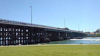
The street begins at the intersection of Leach Highway and Carrington Street, at Fremantle's eastern edge. It travels west as the continuation of State Route 7, meeting Stirling Highway after 1.4 kilometres (0.9mi), at the highway's southern terminus. This stretch of road between Carrington Street and Stirling Highway is a part of Leach Highway.[2] The road continues west for another 600 metres (2,000ft), until it reaches Monument Hill at its intersection with East Street and Swanbourne Street. From there it turns south-west, reaching Ord Street after 300 metres (980ft), which is the western terminus of State Route 7. High Street continues south-west, passing, after 400 metres (1,300ft), through Queens Square,[22][23] a set of four squares around High Street's intersection with Parry Street. Another 230 metres (750ft) along is Queen Street, the north-eastern edge of Kings Square.[22][24][25] High Street is a pedestrian mall through Kings square, and for another 100 metres (330ft) west of the square, until Market Street. South-west from this point, the street is one-way for 400 metres (1,300ft), until it reaches Cliff Street. The road's terminus is only 65 metres (213ft) further along, at Little High Street, adjacent to the Round House.
Historic streetscape
Fremantle Town Hall, High StreetTramlines being laid on High Street 1905
High Street is lined by a significant number of heritage buildings between the Round House and where it becomes a pedestrian mall, at Market Street just west of the Fremantle Town Hall. The buildings include:
At the town hall the pedestrian mall is crossed by the intersection of Adelaide and William streets it then continues through Kings Square until it reaches Queen Street. The section of road through Kings Square is frequently used for festivals and markets. From Queens Street, High Street continues east until it abuts Leach Highway at Carrington street. Along this section of the road there are a number of further significant places including:
↑ Ewers, John K. (1971). The Western Gateway: A History of Fremantle (2nded.). Nedlands, Western Australia: University of Western Australia Press for the Fremantle City Council. p.223. ISBN085564 050 2.
1 2 Ewers, John K. (1971). The Western Gateway: A History of Fremantle (2nded.). Nedlands, Western Australia: University of Western Australia Press for the Fremantle City Council. pp.30, 184. ISBN085564 050 2.
↑ At some stage the four squares that make up Queen Square had been fenced and locked, none remain today "Fremantle Squares". The Daily News. Perth: National Library of Australia. 4 August 1931. p.6 Edition: Home (Final) Edition. Retrieved 7 November 2012.
↑ For comments on King Square at the time of the demolition of building in the southern part of the square in 1929 "An Historic Site". The West Australian. Perth: National Library of Australia. 24 May 1929. p.18. Retrieved 7 November 2012.
↑ "Athena Lodge (fmr)". State Heritage Office – Government of Western Australia. 5 November 2012. Archived from the original on 3 December 2012. Retrieved 19 November 2012.
↑ "Orient Hotel". State Heritage Office – Government of Western Australia. 23 December 2011. Retrieved 19 November 2012.
↑ "Union Stores Building (fmr)". State Heritage Office – Government of Western Australia. 23 December 2011. Retrieved 19 November 2012.
↑ "R.S.L. Club". State Heritage Office – Government of Western Australia. 23 December 2011. Retrieved 19 November 2012.
↑ "ANZ Bank Building". State Heritage Office – Government of Western Australia. 5 November 2012. Archived from the original on 5 December 2012. Retrieved 19 November 2012.
↑ "National Hotel". State Heritage Office – Government of Western Australia. 23 December 2011. Retrieved 19 November 2012.
↑ "Dalkeith House". State Heritage Office – Government of Western Australia. 23 December 2011. Retrieved 19 November 2012.
↑ "Victoria Hall". State Heritage Office – Government of Western Australia. 23 December 2011. Retrieved 19 November 2012.
↑ "Lenaville". State Heritage Office – Government of Western Australia. 23 December 2011. Retrieved 19 November 2012.
↑ "Fremantle Grammar School (fmr)". State Heritage Office – Government of Western Australia. 23 December 2011. Retrieved 19 November 2012.
Fremantle is a port city in Western Australia located at the mouth of the Swan River in the metropolitan area of Perth, the state capital. Fremantle Harbour serves as the port of Perth. The Western Australian vernacular diminutive for Fremantle is Freo.
Scarborough is a coastal suburb of Perth, Western Australia, located approximately 14 km northwest of the city centre in the City of Stirling local government area. Located along the coast of the Indian Ocean, it was named after the English beach resort Scarborough, North Yorkshire.
Subiaco is an inner-western suburb of Perth, the capital of Western Australia. It is approximately 3 km (1.9 mi) west of Perth's central business district, in the City of Subiaco local government area. Historically a working-class suburb containing a mixture of industrial and commercial land uses, since the 1990s the area has been one of Australia's most celebrated urban redevelopment projects. It remains a predominantly low-rise, urban village neighbourhood centred around Subiaco train station and Rokeby Road.
Wagin is a town and shire in the Wheatbelt region of Western Australia, approximately 225 km (139.81 mi) south-east of Perth on the Great Southern Highway between Narrogin and Katanning. It is also on State Route 107. The main industries are wheat and sheep farming.
Bicton is an affluent riverside suburb of Perth, Western Australia, located 10 kilometres (6.2 mi) south-west of the central business district. The suburb is mostly residential, and falls within the City of Melville local government area. Bicton borders the Swan River to the north, with the northern third of the suburb taken up by a Class-A reserve at Point Walter.
The Causeway is an arterial traffic crossing in Perth, Western Australia, linking the inner-city suburbs of East Perth and Victoria Park. It is carried over the Swan River at the eastern end of Perth Water by two bridges on either side of Heirisson Island. The current Causeway is the third structure to have been built across the river at this point.
Stirling Highway is, for most of its length, a four-lane single carriageway and major arterial road between Perth, Western Australia and the port city of Fremantle in Western Australia on the northern side of the Swan River. The speed limit is 60 km/h (37 mph). East of Crawley, it continues as Mounts Bay Road which links Crawley and the nearby University of Western Australia to the Perth central business district.
Queen Victoria Street is the main road entering the city centre of Fremantle, Western Australia, from the direction of Perth. The road was originally named Cantonment Road, but was subsequently renamed Victoria Road, and a few years later Queen Victoria Street, after Queen Victoria of the United Kingdom, to avoid confusion with similarly named roads in the area.
Transport in Perth, Western Australia, is served by various means, among them an extensive highway/freeway network and a substantial system of commuter rail lines and bus routes. Public transport is managed by the Transperth agency.
The earliest trams in Australia operated in the latter decades of the 19th century, hauled by horses or "steam tram motors". At the turn of the 20th century, propulsion almost universally turned to electrification, although cable trams lingered in Melbourne. In cities and towns that had trams, they were a major part of public transport assets.
The Perth tramway network served Perth, the capital city of Western Australia, from 1899 until 1958. The network was initially run by a private company but was taken over by the state government in 1913. From a single line along Hay Street, the network expanded north as far as Osborne Park, east as far as Welshpool, south as far as Como, and west as far as Claremont. The tramways were gradually replaced by buses after World War II.
The Fremantle tramway network linked the central business district of Fremantle, the port city for Perth, Western Australia, with nearby suburbs. Small but comprehensive, it operated between 1905 and 1952. It was not connected with the larger Perth tramway system.
Walyalup Koort, formerly known as Kings Square (or King's Square), is a town square in Fremantle, Western Australia. It is bounded by Queen, Newman, William, and Adelaide Streets. Though the square was originally a public reserve, it has been the site of Saint John's Church of England since 1843, and the Fremantle Town Hall since 1887. High Street was extended through and beyond the square in the 1880s, but the portion through the square was closed off in the 1960s. Today Kings Square functions as a civic and cultural centre of Fremantle, with modern events taking place adjacent to the historic buildings.
Mouat Street is a 300-metre-long (980 ft) street in Fremantle, Western Australia. Historically, the name was often spelled as Mouatt Street.
Cliff Street is a street in Fremantle, Western Australia. It is the furthest west cross street on High Street, running parallel to Mouat Street.
Fremantle West End Heritage area is a designated heritage precinct in Fremantle, Western Australia.
Pakenham Street is a street in Fremantle, Western Australia, in the Fremantle West End Heritage area. It runs between Phillimore Street and Collie Street, the main cross intersection being with High Street.
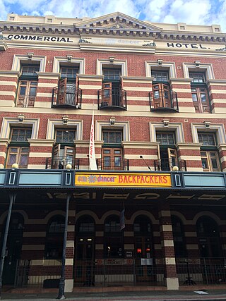
The Commercial Hotel is a hotel at 80 High Street in Fremantle, Western Australia. The current building is of three storeys in the Federation Free Classic style, and was registered on the Register of the National Estate in 1978. It is now the Sundancers Backpackers Hostel.
This page is based on this Wikipedia article Text is available under the CC BY-SA 4.0 license; additional terms may apply. Images, videos and audio are available under their respective licenses.