Palmyra, Western Australia

Last updated

Palmyra
Perth,  Western Australia
Millers' Bakehouse Museum, Palmyra, April 2020 02.jpg
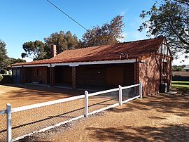
The historic Millers' Bakehouse Museum, Palmyra
Palmyra, Western Australia
Coordinates 32°02′42″S115°47′09″E / 32.044968°S 115.7858881°E / -32.044968; 115.7858881 (Palmyra) Coordinates: 32°02′42″S115°47′09″E / 32.044968°S 115.7858881°E / -32.044968; 115.7858881 (Palmyra)
Population6,950 (2016 census) [1]
 • Density2,240/km2 (5,810/sq mi)
Postcode(s) 6157
Area3.1 km2 (1.2 sq mi)
Location16 km (10 mi) from Perth
LGA(s) City of Melville
State electorate(s) Bicton / Fremantle
Federal division(s) Fremantle
Suburbs around Palmyra:
East Fremantle Bicton Attadale
East Fremantle Palmyra Melville
White Gum Valley O'Connor Willagee

Palmyra is a suburb of Perth, Western Australia, located within the City of Melville.

The suburb east of Fremantle appears to have been first established as the Palmyra Estate in 1903. [2] The north-eastern corner of Palmyra is some 14 kilometres (8.7 mi) from the Perth G.P.O.

The W.A. State Primary School the corner of what was then McKimmie Street (now McKimmie Road) between Zenobia and Aurelian Streets, was established in 1913. Its first Centenary was celebrated enthusiastically by students, residents and past pupils on Saturday 9 November 2013. [3] There is also a School associated with the Catholic Our Lady of Fatima Church at 8 Foss Street. The St Peter and St Mark Anglican Church is a 2 Hammad Road. The Uniting Church is at the corner of Carrington Street and the Canning Highway. The Seventh Day Adventist Church meets on Saturdays at 10 Cleopatra Street.

Palmyra includes the Fremantle Cemetery at its south-eastern suburb boundary, south of High Street/Leach Highway. Starting from its northern boundary, clockwise, Palmyra is bounded by the Canning Highway; by Stock Road on its East; by Sainsbury Road on its South; and in a dog-leg, by Carrington Street on its West, and Marmion Street on its South, and Petra Street on its West.

The Melville History Society meets at the Miller Bakehouse, corner of Elvira and Baal Streets, Palmyra. [4]

There are a number of parks in Palmyra;

Related Research Articles

City of Melville Local government area in Western Australia

The City of Melville is a local government area in the southern suburbs of the Western Australian capital city of Perth, east of the port city of Fremantle and about 12 kilometres (7.5 mi) south of Perth's central business district. The City covers an area of 52.73 square kilometres (20.36 sq mi) and had a population of about 98,000 as at the 2016 Census.

Peppermint Grove, Western Australia Suburb of Perth, Western Australia

Peppermint Grove is an affluent western suburb of Perth, Western Australia on the north bank of the Swan River at Freshwater Bay. Its local government area, the smallest in the country, is the Shire of Peppermint Grove. The suburb was named after its trademark Swan River peppermint trees lining many streets. The suburb has long been associated with Western Australia's wealthiest and oldest families. Their prosperity is reflected in the many historical houses in the area, such as The Cliffe and the Federation Queen Anne style St Just. Colin Barnett, a former Premier of Western Australia, dubbed the suburb "Monaco of WA" due to its small size and concentration of wealth.

Leeming, Western Australia Suburb of Perth, Western Australia

Leeming is a southern suburb of Perth, Western Australia. It is divided between the three local government areas of the City of Melville, the City of Cockburn (south) and the City of Canning (north-east). It is located approximately 17 kilometres (11 mi) south of the Perth central business district and 13 kilometres (8.1 mi) east of Fremantle.

Sorrento, Western Australia Suburb of Perth, Western Australia

Sorrento is a northern coastal suburb of Perth, the capital city of Western Australia in the local government area of the City of Joondalup. At its northwestern corner is the Hillarys Boat Harbour, built in the late 1980s.

Bicton, Western Australia Suburb of Perth, Western Australia

Bicton is an affluent riverside suburb of Perth, Western Australia, located 10 kilometres (6.2 mi) south-west of the central business district. The suburb is mostly residential, and falls within the City of Melville local government area. Bicton borders the Swan River to the north, with the northern third of the suburb taken up by a Class-A reserve at Point Walter.

Duncraig, Western Australia Suburb of Perth, Western Australia

Duncraig is a northern suburb of Perth, the capital city of Western Australia, and is located 16 kilometres (10 mi) north of Perth's central business district (CBD) between Marmion Avenue and Mitchell Freeway. Its local government area is the City of Joondalup.

Attadale, Western Australia Suburb of Perth, Western Australia

Attadale is a riverside suburb of Perth, Western Australia, located within the City of Melville.

Bateman is a suburb of Perth, Western Australia, located within the City of Melville.

Kardinya, Western Australia Suburb of Perth, Western Australia

Kardinya is a suburb 13 kilometres (8 mi) south-southwest of the central business district of Perth, the capital of Western Australia. It is in the City of Melville local government area. It is predominantly a low-density residential suburb consisting of single-family detached homes. There is a commercial area in the centre of the suburb, with a shopping centre and several other shops. In the northwest is a small light industrial area. Kardinya has a population of 8,730 people.

Willagee, Western Australia Suburb of Perth, Western Australia

Willagee is a suburb of Perth, Western Australia 15 kilometres (9 mi) south-southwest of the Perth central business district. It is within the local government area of City of Melville, and the electoral district of Willagee, which takes its name from the suburb.

Willetton, Western Australia Suburb of Perth, Western Australia

Willetton is a large southern suburb of Perth, Western Australia. Its local government area is the City of Canning.

Hillarys is a northern coastal suburb of Perth, the capital city of Western Australia, in the local government area of the City of Joondalup. It is part of the Whitfords precinct, and is located 21 km north-northwest of Perth's central business district via Mitchell Freeway and Hepburn Avenue.

Leach Highway

Leach Highway is a 23-kilometre (14 mi) east-west arterial highway in the southern suburbs of Perth, Western Australia, primarily linking Kewdale and Perth Airport with the city of Fremantle.

East Fremantle, Western Australia Suburb of Perth, Western Australia

East Fremantle is a suburb of Perth, Western Australia, located 13 kilometres (8.1 mi) south-west of the central business district. The suburb is mainly residential, and is coterminous with the Town of East Fremantle local government area.

Fremantle Cemetery Cemetery in Fremantle, Western Australia

Fremantle Cemetery is a 46-hectare (110-acre) cemetery located in the eastern part (Palmyra) of Fremantle, Western Australia. Established in 1898, it is known as the final resting place of Bon Scott, several murderers and dozens of other notable Australians. There have been over 60,000 cremations and over 40,000 burials there. The grave of Scott, the AC/DC singer, has been said to be the most visited grave in Australia.

Transport in Perth, Western Australia, is served by various means, among them an extensive highway / freeway network and a substantial system of commuter rail lines and bus routes. Public transport is managed by the Transperth agency.

Trams in Fremantle Tram network in Fremantle, Western Australia

The Fremantle tramway network linked the central business district of Fremantle, the port city for Perth, Western Australia, with nearby suburbs. Small but comprehensive, it operated between 1905 and 1952. It was not connected with the larger Perth tramway system.

High Street, Fremantle Street in Fremantle, Western Australia

High Street is the main street running through the City of Fremantle, Western Australia. The street passes by historic landmarks, including the Round House, the Fremantle Town Hall, and the Fremantle War Memorial, through the Fremantle West End Heritage area and through two town squares. Trams operated along High Street for 47 years, between 1905 and 1952. Running east–west, High Street continues as Leach Highway, a major arterial road, at Stirling Highway, linking Fremantle with Perth Airport although the stretch of road between Stirling Highway and Carrington Street is known locally—and signed—as High Street.

The Fremantle Eastern Bypass was a proposed bypass of Fremantle, Western Australia, which would have linked Stirling Highway with Roe Highway. A highway link from Roe Highway to Fremantle Port was proposed in the Metropolitan Region Scheme since the 1950s. A reservation for the bypass was included in the scheme in 1973. It was deleted at the request of the state government's Minister for Planning in 1992, reinstated in 1994 following a change of government, and once more deleted in 2004 after another change of government in 2001.

Electoral district of Bicton State electoral district of Western Australia

Bicton is an electoral district of the Legislative Assembly of Western Australia. It is located in Perth's southern suburbs, and named after the riverside suburb of Bicton.

References

  1. Australian Bureau of Statistics (27 June 2017). "Palmyra (State Suburb)". 2016 Census QuickStats. Retrieved 19 October 2020. OOjs UI icon edit-ltr-progressive.svg
  2. "21 Aug 1903 - PALMYRA. - Trove".
  3. "pally is 100 | Celebrating Palmyra Primary School's Centenary in 2013".
  4. "Melville History Society". Archived from the original on 10 April 2013.

Commons-logo.svg Media related to Palmyra, Western Australia at Wikimedia Commons