
Riverton is a southeastern suburb of Perth, the capital city of Western Australia. Its local government area is the City of Canning.

Booragoon bus station is a Transperth bus station located next to the Westfield Booragoon shopping centre in Booragoon, Western Australia. It has 13 stands and is served by nine Transperth routes, in addition to a number of school buses and School Special services.

Ardross is a suburb of Perth, Western Australia, located within the City of Melville. It was once an area of land acquired by the Scotsman, Sir Alexander Percival Matheson in 1896. In Matheson's subdivision of the adjoining suburb of Applecross, he created "Ardross Street" naming it after either the town of Ardrossan on the Scottish west coast or Ardross Castle, located about 40 kilometres north of Inverness. The suburb derives its name from this street.

Alfred Cove is a southern suburb of Perth, Western Australia. Its local government area is the City of Melville.

Applecross is an affluent riverside suburb of Perth, Western Australia, bounded by Canning Highway and the Swan River. It is located within the City of Melville.
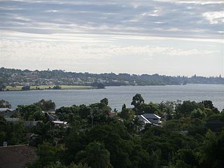
Attadale is a riverside suburb of Perth, Western Australia, located within the City of Melville.
Brentwood is a suburb of Perth, Western Australia, located within the City of Melville and approximately 10 kilometres (6.2 mi) from Perth city centre. The nearest airport is Perth Airport and the nearest railway station is Bull Creek.

Mount Pleasant is a suburb of Perth, Western Australia, located within Wajuk country, and the City of Melville, on the Canning River. It is bounded by Canning Highway to the north, the Canning River to the east, Cranford Avenue, Moolyeen Road and Canning Avenue to the south, and Rogerson Road, Coomoora Road, Henley Road and Ardross Street to the west.

Bentley is a southern suburb of Perth, the capital city of Western Australia, 8 kilometres (5.0 mi) southeast of Perth's central business district. Its local government areas are the City of Canning and the Town of Victoria Park. Bentley is home to the main campus of Curtin University and Technology Park.

Cannington is a southern suburb of Perth, Western Australia. Its local government area is the City of Canning.
Rossmoyne is a suburb of Perth, Western Australia, within the City of Canning. Rossmoyne is located 14 kilometres (8.7 mi) south of central Perth, and is bounded by Leach Highway to the south, the Bull Creek to the west, the Canning River to the north, and Shelley to the east.
Shelley is a suburb of Perth, Western Australia, located within the City of Canning.
St James is a suburb shared between the Town of Victoria Park and the City of Canning in the Perth metropolitan area.

Willetton is a large southern suburb of Perth, Western Australia. Its local government area is the City of Canning.
Wilson is a suburb of Perth, Western Australia, located within the City of Canning on the north bank of the Canning River. It is a fairly old suburb with parks and close proximity to prominent shopping centres in South Perth. It is favoured by Curtin University students, the reason being its convenient access to the university. Bus numbers 72 and 75 travel through this suburb. The suburb contains Castledare, Kent Street Weir, Canning River and Lo Quay River Cafe. Wilson is located quite closely to various park, some of those being Cetenary Park, Thomas Moore Park, and Alderley Park.

Beckenham is a suburb of Perth, Western Australia, located within the City of Gosnells.

Bull Creek railway station is a railway station on the Transperth network. It is located on the Mandurah line, 11.7 kilometres from Perth station inside the median strip of the Kwinana Freeway serving the suburb of Bull Creek.

Westfield Booragoon is a major regional shopping centre in the city of Perth, Western Australia. Westfield Booragoon is located at the corner of Marmion Street and Riseley Street in the southern suburb of Booragoon. 50% of the shopping complex is owned by Dexus with the remaining 50% owned by Scentre Group which owns and operates its properties under the Westfield name from which the company is derived.

East Fremantle is a suburb of Perth, Western Australia, located 13 kilometres (8.1 mi) south-west of the central business district. The suburb is mainly residential, and is coterminous with the Town of East Fremantle local government area.

Nedlands is a western suburb of Perth, the capital city of Western Australia. It is a part of the local government areas of the City of Nedlands and the City of Perth. It is about 7 kilometres (4 mi) from the Perth CBD via either Thomas Street or Mounts Bay Road.

