
The Fremantle Arts Centre is a historic building complex on Ord Street in Fremantle, Western Australia.

The Fremantle Markets is a public market located on the corner of South Terrace and Henderson Street, Fremantle, Western Australia.
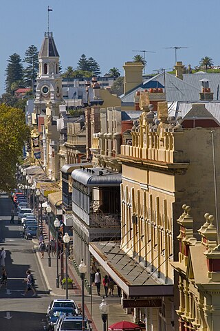
High Street is the main street running through the City of Fremantle, Western Australia. The street passes by historic landmarks, including the Round House, the Fremantle Town Hall, and the Fremantle War Memorial, through the Fremantle West End Heritage area and through two town squares. Trams operated along High Street for 47 years, between 1905 and 1952. Running east–west, High Street continues as Leach Highway, a major arterial road, at Stirling Highway, linking Fremantle with Perth Airport although the stretch of road between Stirling Highway and Carrington Street is known locally—and signed—as High Street.

7 High Street, Fremantle is a historically significant building in the Fremantle West End Heritage area of Fremantle, Western Australia. It was constructed for the Bank of New South Wales in 1899, during the gold boom of the late nineteenth and early twentieth centuries and when Fremantle was a primary centre of trade and commerce. The building is largely unchanged since that time, and is a good example of Federation Free Classical architecture: a single-storey stone and brick construction, with fine timber features within and an elaborate stucco façade. The building comprises three rooms and a main bank chamber, and is on the corner of Cliff Street.

Mouat Street is a 300-metre-long (980 ft) street in Fremantle, Western Australia. Historically, the name was often spelled as Mouatt Street.
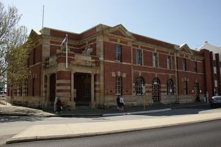
The Old Customs House is a building in Fremantle, Western Australia that was built in 1908 to house the main branch of the Customs Department of Western Australia. It is one of only a handful of extant Customs Houses in the state; others are in Albany, Broome, Cossack, and Geraldton.

The National Hotel is on the corner of High and Market Streets Fremantle. Originally built as a shop in 1868, it was occupied by the National Bank in the early 1880s. When the bank relocated in 1886, the building became the National Hotel.
The former P&O Building, also known as the Australian Union Steamship Navigation Company building, is a heritage-listed building in Phillimore Street in the west end of Fremantle, Western Australia.

Wilhemsen House, also known as the Elders Building, Elder Building, Barwil House and the Dalgety & Co. Building, is a heritage building located at 11 Cliff Street on the corner of Phillimore Street in the port city of Fremantle, Western Australia. The building dates from the gold rush boom period in the late nineteenth and early twentieth centuries and is of historic significance.

Phillimore Street is a street in Fremantle, Western Australia; it runs between Queen Street, outside the Fremantle railway station and Cliff Street.

Fremantle West End Heritage area is a designated heritage precinct in Fremantle, Western Australia.

Collie Street is in Fremantle, Western Australia.

Pakenham Street is a street in Fremantle, Western Australia, in the Fremantle West End Heritage area. It runs between Phillimore Street and Collie Street, the main cross intersection being with High Street.

The Frank Cadd Building also known as the Fares House, is a heritage listed building located at 33 Phillimore Street, on the corner of Henry Street in the Fremantle West End Heritage area. It was one of many commercial buildings constructed in Fremantle during the gold boom period in the late nineteenth and early twentieth century.

The former Union Bank of Australia Building, also known as the ANZ Bank Building, is a heritage listed building located at 86 High Street in the Fremantle West End Heritage area. It was one of many commercial buildings constructed in Fremantle during the interwar period.

The former Westpac Building, also known as the Challenge Bank Building and the Western Australian Bank Building, is a heritage listed building located at 22 High Street on the corner with Mouat Street in the Fremantle West End Heritage area. It was one of many commercial buildings constructed in Fremantle during the gold boom period in the late nineteenth and early twentieth century.

The Evan Davies Building, also known as the Literary Institute Building, is a heritage listed building located at 13 South Terrace, Fremantle, Australia, on the corner with Collie Street. It was one of many buildings constructed in Fremantle during the gold boom period in the late nineteenth and early twentieth century.

Owston's Buildings, also known as Ouston's building, is a heritage listed building located at 9-23 High Street on the corner with Mouat Street in the Fremantle West End Heritage area. It was one of many buildings constructed in Fremantle during the gold boom period in the late nineteenth and early twentieth century.

Higham's Buildings is a heritage listed building located at 101 High Street, on the corner of Market Street in the Fremantle West End Heritage area. It is one of many commercial buildings constructed in Fremantle during the gold boom period in the late nineteenth and early twentieth century.
The Robert Harper Building, also known as Jebsens, is a heritage-listed building located at 49 Phillimore Street, on the corner of Pakenham Street in the Fremantle West End Heritage area. It is one of many commercial buildings constructed in Fremantle during the gold boom period in the late nineteenth and early twentieth century.

