Marine Terrace, Fremantle

Last updated

Marine Terrace

WTF Josh Bluntschli Tram.JPG
A tourist tram on Marine Terrace
Marine Terrace, Fremantle
General information
TypeRoad
Length2.3 km (1.4 mi) [1]
Major junctions
Northwest end
 
South endDouro Road
Location(s)
Major suburbs Fremantle, South Fremantle

Marine Terrace is a road on the southern side of the built up area of Fremantle, Western Australia. It is named for its location alongside the water front. [2]

Contents

At various stages in its history it has had significant processions along the terrace. [3] The trees that currently line the terrace are not found in early photographs. [4]

In 1896 a quarantine station was set up at South Beach, at the end of the road, to process camels shipped in to Western Australia. [2] The camels would arrive at the Long Jetty, be driven along Marine Terrace, and then made to camp at the quarantine site. [2] The animals would later be taken to the Goldfields. [2]

It is bound by Esplanade Park [5] on its west side and has the Esplanade Hotel on the east side, along with a number of other heritage listed buildings. [6] It is also part of the south west boundary of the Fremantle West End Heritage area.

Intersections

LGALocation [1] kmmiDestinationsNotes
Fremantle Fremantle 00.0 Cliff Street / Wardan Lane Roundabout; Wardan Lane is one-way northbound; roundabout also contains car park access
0.070.043 Mouat Street T-junction; Mouat Street is one-way southbound
0.160.099 Henry Street T-junction; Henry Street is one-way southbound
0.220.14 Collie Street T-junction
0.30.19Essex Street T-junction
0.40.25 Norfolk Street Roundabout
0.550.34Suffolk Street T-junction
0.60.37Mews Road T-junction
0.650.40Arundel StreetArundel Street is one-way westbound only; left turn from Arundel Street to Marine Terrace southbound only
0.70.43Howard StreetGive way sign controlled T-junction; Howard Street westbound must turn left onto Marine Terrace southbound
0.80.50Russell Street Left-in/left-out
0.90.56Grey Street T-junction
10.62Price Street Left-in/left-out
Fremantle - South Fremantle boundary1.10.68 South Street Give way sign controlled seagull intersection
South Fremantle 1.10.68Yuna Lane Left-in/left-out
1.30.81Wyola Lane T-junction
1.30.81Louisa Street Left-in/left-out
1.40.87Rose Street Left-in/left-out
1.40.87Capo D'Orlando DriveTraffic light controlled T-junction
1.40.87Ada StreetLeft turn from Ada Street westbound onto Marine Terrace southbound only
1.50.93King William StreetLeft turn from King William Street westbound onto Marine Terrace southbound and right turn from Marine Terrace northbound onto King William Street eastbound only
1.60.99Sydney StreetLeft turn from Sydney Street westbound onto Marine Terrace southbound only
1.71.1Jenkin Street T-junction
1.81.1Sheedy Street Left-in/left-out
1.81.1Success Harbour entry roadTraffic light controlled T-junction
2.31.4Douro RoadMarine Terrace continues east as Douro Road
1.000 mi = 1.609 km; 1.000 km = 0.621 mi

See also

Australia road sign W5-29.svg   Australian Roadsportal

Related Research Articles

<span class="mw-page-title-main">The Causeway</span> Road bridge in Perth, Western Australia

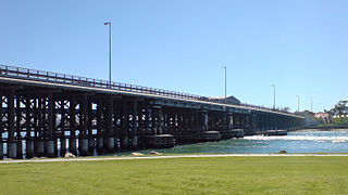
The Causeway is an arterial traffic crossing in Perth, Western Australia, linking the inner-city suburbs of East Perth and Victoria Park. It is carried over the Swan River at the eastern end of Perth Water by two bridges on either side of Heirisson Island. The current Causeway is the third structure to have been built across the river at this point.

<span class="mw-page-title-main">Barrack Street</span> Street in CBD of Perth, Western Australia

Barrack Street is one of two major cross-streets in the central business district of Perth, Western Australia. Together with St Georges Terrace, Wellington Street and William Street it defines the boundary of the main shopping precinct of the central city.

<span class="mw-page-title-main">William Street, Perth</span> Street in CBD Perth, Western Australia

William Street is a suburban distributor and one of two major cross-streets in the central business district of Perth, Western Australia. Commencing in western Mount Lawley, its route takes it through the Northbridge café and nightclub district as well as the CBD.

<span class="mw-page-title-main">Queen Victoria Street, Fremantle</span> Road in Fremantle, Western Australia

Queen Victoria Street is the main road entering the city centre of Fremantle, Western Australia from the direction of Perth. The road was originally named Cantonment Road, but was subsequently renamed Victoria Road, and a few years later Queen Victoria Street, after Queen Victoria of the United Kingdom, to avoid confusion with similarly named roads in the area.

<span class="mw-page-title-main">Mounts Bay Road</span> Road in Perth, Western Australia

Mounts Bay Road is a major road in Perth, Western Australia, extending southwest from the central business district along the north bank of the Swan River, at the base of Kings Park.

<span class="mw-page-title-main">Riverside Drive, Perth</span> Road in Perth, Western Australia

Riverside Drive in Perth, Western Australia, is a road on the northern side of Perth Water. It was built on reclaimed land in the 1930s, and links The Causeway to the Narrows Bridge.

<span class="mw-page-title-main">Esplanade Hotel (Fremantle)</span> Heritage listed building in Fremantle

The Esplanade Hotel is a hotel located opposite Esplanade Park in Fremantle, Western Australia. The building stands on the site of the first building used for housing convicts transported from Great Britain in 1850.

<span class="mw-page-title-main">Sherwood Court, Perth</span> Street in Perth, Western Australia

Sherwood Court is a short sloping road between St Georges Terrace in Perth, Western Australia and The Esplanade with Allendale Square on the upper corner, and Lawson Apartments on the lower.

<span class="mw-page-title-main">Old Fremantle Police Station and Court House Complex</span> Heritage listed building in Fremantle, Western Australia

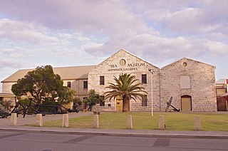
The Old Fremantle Police Station and Court House Complex is a heritage-listed group of buildings located at 45 Henderson Street, Fremantle, Western Australia. The complex includes the former courthouse, police station, police barracks and lock-up and artillery drill hall.

<span class="mw-page-title-main">High Street, Fremantle</span> Street in Fremantle, Western Australia

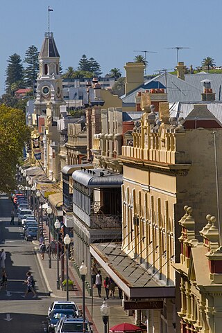
High Street is the main street running through the City of Fremantle, Western Australia. The street passes by historic landmarks, including the Round House, the Fremantle Town Hall, and the Fremantle War Memorial, through the Fremantle West End Heritage area and through two town squares. Trams operated along High Street for 47 years, between 1905 and 1952. Running east–west, High Street continues as Leach Highway, a major arterial road, at Stirling Highway, linking Fremantle with Perth Airport although the stretch of road between Stirling Highway and Carrington Street is known locally—and signed—as High Street.

<span class="mw-page-title-main">Esplanade Park, Fremantle</span> Public reserve in Fremantle

Esplanade Park is a public reserve in Fremantle, Western Australia. Situated on Marine Terrace and opposite the Esplanade Hotel, the reserve features about 100 mature Norfolk Island pines and the Explorers' Monument.

<span class="mw-page-title-main">South Terrace, Fremantle</span> Road in Fremantle, Western Australia

South Terrace, Fremantle is a road in Fremantle, Western Australia that is renowned as the "Cappucino Strip" of Fremantle, due to the high number of coffee shops and restaurants.

<span class="mw-page-title-main">Market Street, Fremantle</span> Street in Fremantle, Western Australia

Market Street, Fremantle is the location of the Fremantle Post Office in Fremantle, Western Australia.

<span class="mw-page-title-main">Commissariat Buildings</span> Buildings in the West End of Fremantle, Western Australia

The Commissariat Buildings are a group of two buildings found at 6 Marine Terrace in the West End of Fremantle, Western Australia, which, with construction having begun in 1852, are one of the first sites built using convict labour in the Swan River colony.

<span class="mw-page-title-main">Mouat Street, Fremantle</span> Street in Fremantle, Western Australia

Mouat Street is a 300-metre-long (980 ft) street in Fremantle, Western Australia. Historically, the name was often spelled as Mouatt Street.

Tourist Drives in Western Australia are routes through areas of scenic or historic significance, designated by route markers with white numbers on a brown shield. Tourist Drives were introduced into Western Australia while Eric Charlton was the state government Minister for Transport in the 1990s. The 28 numbered routes collectively traverse more than 2,000 kilometres (1,200 mi) across the state. In addition to the Tourist Drives, there are unnumbered routes such as the Golden Pipeline Heritage Trail, and local governments may designate and maintain local scenic drives, generally unnamed and unnumbered.

<span class="mw-page-title-main">Stirling Terrace, Toodyay</span> Street in Toodyay, Western Australia

Stirling Terrace is the main street of Toodyay, Western Australia, originally called New Road until 1905.

<span class="mw-page-title-main">Milligan Street, Perth</span> Road in Perth, Western Australia

Milligan Street is a street in Perth, Western Australia that runs from St Georges Terrace to north of Wellington Street. The northern section provides access to the Perth Arena carpark and Telethon Avenue; there are also dedicated Transperth bus roads connecting to the northern end, south of the Fremantle railway line.

<span class="mw-page-title-main">Collie Street, Fremantle</span> Street in Fremantle, Western Australia

Collie Street is in Fremantle, Western Australia.

References

  1. 1 2 "Marine Terrace". Google Maps. Retrieved 3 December 2022.
  2. 1 2 3 4 Ewers, John K. (1971). The Western Gateway: A History of Fremantle (2nd ed.). Nedlands, Western Australia: University of Western Australia Press for the Fremantle City Council. p. 225. ISBN   085564-050-2.
  3. "The Fremantle Eight Hours Procession passing along Marine Terrace". Western Mail (Perth, WA : 1885 - 1954) . Perth, WA. 26 October 1907. p. 26. Retrieved 9 November 2012 via National Library of Australia.
  4. "The Marine Terrace, Fremantle". Kalgoorlie Western Argus (WA : 1896 - 1916) . WA. 12 November 1907. p. 25. Retrieved 9 November 2012 via National Library of Australia.
  5. Woldendorp, Richard, 1927-; HRRC (1996), Aerial photograph of the Esplanade Reserve and Marine Terrace, Fremantle [picture] , retrieved 9 November 2012{{citation}}: CS1 maint: multiple names: authors list (link) CS1 maint: numeric names: authors list (link)
  6. Ian Molyneux and Associates Architects; D'Arcy, Rima; Heritage Council of Western Australia (1990), A conservation plan for the former Fremantle Courthouse, Marine Terrace, Fremantle, Western Australia : a report on a survey and assessment, Heritage Council of W.A. [distributor], retrieved 9 November 2012
Template:Attached KML/Marine Terrace, Fremantle
KML is from Wikidata