The Swan River is a river in the south west of Western Australia. The river runs through the metropolitan area of Perth, Western Australia's capital and largest city.

Fremantle is a port city in Western Australia, located at the mouth of the Swan River in the metropolitan area of Perth, the state capital. Fremantle Harbour serves as the port of Perth. The Western Australian vernacular diminutive for Fremantle is Freo.

The West Australian Football League (WAFL) is an Australian rules football league based in Perth, Western Australia. The league currently consists of ten teams, which play each other in a 20-round season usually lasting from March to September, with the top five teams playing off in a finals series, culminating in a Grand Final. The league also runs reserves, colts (under-19) and women's competitions.

Bicton is an affluent riverside suburb of Perth, Western Australia, located 10 kilometres (6.2 mi) south-west of the central business district. The suburb is mostly residential, and falls within the City of Melville local government area. Bicton borders the Swan River to the north, with the northern third of the suburb taken up by a Class-A reserve at Point Walter.
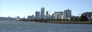
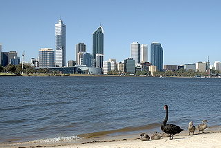
Perth Water is a section of the Swan River on the southern edge of the central business district of Perth, Western Australia. It is between the Causeway to the east, and Narrows Bridge to the west – a large wide but shallow section of river, and the northern edge of the suburb South Perth. It is considered a landmark of the City of Perth.

East Fremantle Oval is an Australian rules football ground located in East Fremantle, Western Australia. The ground was opened in 1906, and underwent a large redevelopment in 1953. It current serves as the home ground of the East Fremantle Football Club in the West Australian Football League (WAFL). East Fremantle Oval has a capacity of around 20,000 people, but has hosted in excess of this number previously, with a record crowd of 21,317 for a match between East Fremantle and South Fremantle in 1979.
Challenger Harbour is a marina in Fremantle, Western Australia adjacent to the Fremantle Fishing Boat Harbour. The harbour breakwater covers the historical site of the Fremantle Long Jetty.

Perth Stadium, currently known as Optus Stadium for sponsorship reasons, is a multi-purpose stadium in Perth, Western Australia, located in the suburb of Burswood. It was completed in late 2017 and officially opened on 21 January 2018. The stadium's total capacity is 61,266, including standing room, making it the third-largest stadium in Australia. The stadium can be extended up to 65,000 seats for rectangular sports.
Cricket is one of the most popular sports in Western Australia. The governing body of the game in WA is the Western Australian Cricket Association (WACA). Western Australia is represented at Sheffield Shield and domestic one-day level by the Western Warriors, and in the Big Bash League by the Perth Scorchers.
The Esplanade Reserve in Perth, Western Australia was a heritage listed public space between Perth Water and the Perth central business district. It formed part of, and was occasionally referred to incorrectly as, the Perth foreshore and the Perth waterfront. The public space was resumed by the Western Australian state government in April 2012 as part of the Elizabeth Quay redevelopment of the Perth waterfront area.

The north shore of Perth Water on the Swan River frontage to the city of Perth in Western Australia has been frequently changed since the arrival of Europeans in 1829. Various forms and structures have appeared and been removed over the last 190 years. Jetties, ports and various forms of reclamation have moved the shore considerably into Perth Water. The main eras of reclamation were in the 1870s, 1900s, 1920s-1937, 1955–1959, and 1967.

Riverside Drive in Perth, Western Australia, is a road on the northern side of Perth Water. It was built on reclaimed land in the 1930s, and links The Causeway to the Narrows Bridge.

The Florence Hummerston Kiosk is a building located at Elizabeth Quay in Perth, Western Australia. The kiosk was originally located on the Perth Esplanade, until being relocated to the foreshore of the Swan River. The kiosk is also known as The Esplanade Kiosk

Elizabeth Quay is a mixed-use development project in the Perth central business district. Focusing on an area located on the north shore of Perth Water near the landmark Swan Bells, the precinct being developed by the project was named in honour of the former Queen Elizabeth II during her Diamond Jubilee.

The Esplanade Hotel is a hotel located opposite Esplanade Park in Fremantle, Western Australia. The building stands on the site of the first building used for housing convicts transported from Great Britain in 1850.

Sherwood Court is a short sloping road between St Georges Terrace in Perth, Western Australia and The Esplanade with Allendale Square on the upper corner, and Lawson Apartments on the lower.

South Perth Esplanade is the name of the foreshore area of Perth Water from Point Belches to Mends Street Jetty in South Perth, Western Australia.

Marine Terrace is a road on the southern side of the built up area of Fremantle, Western Australia. It is named for its location alongside the water front.

Rockingham is a suburb of Perth, Western Australia, located 47 km south-south-west of the city centre. It acts as the primary centre for the City of Rockingham. It has a beachside location at Mangles Bay, the southern extremity of Cockburn Sound. To its north stretches the maritime and resource-industry installations of Kwinana and Henderson. Offshore to the north-west is Australia's largest naval fleet and submarine base, Garden Island, connected to the mainland by an all-weather causeway. To the west and south lies the Shoalwater Islands Marine Park.

