Cottesloe, Western Australia

Last updated

Cottesloe
Perth,  Western Australia
Cottesloe beach.jpg
View of Cottesloe Beach in summer 2006/07
Cottesloe, Western Australia
Coordinates 31°59′35″S115°45′25″E / 31.993°S 115.757°E / -31.993; 115.757
Population7,750 (SAL 2021) [1]
 • Density2,256.9/km2 (5,845/sq mi)
Established1870 [2]
Postcode(s) 6011
Elevation11 m (36 ft)
Area3.856 km2 (1.489 sq mi)
Location11 km (7 mi) WSW of Perth CBD
LGA(s) Town of Cottesloe
State electorate(s) Cottesloe
Federal division(s) Curtin
Suburbs around Cottesloe:
Indian Ocean Swanbourne Claremont
Indian Ocean Cottesloe Peppermint Grove
Indian Ocean Mosman Park Mosman Park

Cottesloe is a western suburb of Perth, Western Australia, within the Town of Cottesloe. Cottesloe was named for Thomas Fremantle, 1st Baron Cottesloe, a prominent Tory politician and the brother of Admiral Sir Charles Fremantle for whom the city of Fremantle was named. The nearby suburb of Swanbourne was named for the Fremantle family seat, Swanbourne House, in Swanbourne, Buckinghamshire.

Contents

Cottesloe was home to Australian Prime Minister John Curtin. The house he built still stands in Jarrad Street. It is now vested jointly in the National Trust of Australia (WA) and Curtin University.

Geography

Cottesloe is a beach-side suburb of the city of Perth in Western Australia. It is located roughly halfway between Perth's central business district and the port of Fremantle. It is famous for its beaches, cafes and relaxed lifestyle.

Cottesloe is bounded by the Indian Ocean to the west; a line extending from Boundary Road, Mosman Park to the ocean to the south; the Perth-Fremantle Railway, Stirling Highway, Congdon Street and West Coast Highway to the east; and North Street to the north. Cottesloe is generally residential, with a significant shopping area located between Jarrad and Station streets adjacent to the Cottesloe railway station. [3]

Population

In the 2016 census, there were 7,375 people in Cottesloe, 68.8% of whom were born in Australia. The most common other countries of birth were England 8.6%, South Africa 1.8%, New Zealand 1.6% and United States of America 1.4%. 86.6% of people spoke only English at home. The most common responses for religion were No Religion 36.4%, Anglican 22.6% and Catholic 19.3%. [4]

Of the occupied private dwellings in Cottesloe, 66.9% were separate houses, 14.9% were semi-detached, row or terrace houses, townhouses etc., and 18.1% were flat or apartments. [4]

Of the employed people in Cottesloe, 7.2% worked in hospitals (except psychiatric hospitals). Other major industries of employment included legal services 3.6% and general practice medical services 3.0%. [4]

Present day

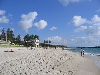
Historically Cottesloe Beach and its panorama are reflections of the changes in the last 110 years of Perth's history. The photos and paintings of Cottesloe Beach that are either in collections or published, give tangible evidence of the importance of beach-oriented activities in the Perth community. Cottesloe Beach is a popular place for beach cricket. An oceanway allows pedestrians and cyclists to move along the beaches.

It is one of Perth's most popular beaches and in 2009, Lonely Planet named Cottesloe Beach the world's 2nd best beach for families. [5]

The Indiana Tea House, which overlooks Cottesloe Beach, is also an icon of the suburb, and in 2021 it was added to the Western Australia Heritage Register. [6]

A new town planning scheme was approved for Cottesloe allowing developers to build to five storeys high along Marine Terrace with the Ocean Beach Hotel site allowed to reach eight storeys. The decision followed a two decade long debate. [7]

A plan to build a skatepark in Cottesloe in 2020, had resulted in heated debate between locals and skateboarders. [8]

CottesloeBeach gobeirne.jpg
Cottesloe Beach and the iconic Indiana Tea House

Transport

Cottesloe is served by Swanbourne, Grant Street, Cottesloe, Mosman Park and Victoria Street railway stations on the Fremantle line. Various bus routes along Stirling Highway and through the suburb's western and eastern sections link Cottesloe to Perth and Fremantle. All services are operated by the Public Transport Authority. Cottesloe is serviced by the 102 operated by Swan Transit.

Bus

Rail

Beach cricket being played at Cottesloe Beach Beach cricket.jpg
Beach cricket being played at Cottesloe Beach
Kayaking competition at Cottesloe beach on a Western Australian Sunday Kayaking competition Cottesloe.JPG
Kayaking competition at Cottesloe beach on a Western Australian Sunday

Politics

From 1901 to 1968 and from 1974 to 1980 Cottesloe was part of the Fremantle electorate, since 1934 a notional Labor seat. Its most prominent member was wartime Prime Minister John Curtin, a Cottesloe resident. [13]

Since 1980, it has been part of the federal division of Curtin. Curtin is regarded as a safe seat for the centre-right Liberal Party, which has held the seat continually since its inception, with the exception of a period from 1995 to 1998 when former Liberal member Allan Rocher held the seat as an independent and since 2022 when the current independent member Kate Chaney was elected. In the parliament of Western Australia, its Legislative Assembly electoral district is Cottesloe, held consecutively by three Liberal Party leaders, currently David Honey. [14] [15]

Notable residents

John Curtin, Prime Minister of Australia for much of World War II, was local federal member of parliament from 1928 to 1931 and 1934 to 1945. He lived in Cottesloe from 1918 until his death in office in 1945. [16] Curtin's house in Jarrad Street is vested in the National Trust of Australia (WA) and Curtin University. During 2008 there was a suggestion that the house be relocated to the Curtin University grounds but the decision was made that the house remain in Cottesloe. [17] In May 2009 the federal government announced that it would provide a grant of $580,000 to the National Trust to restore the house. [18]

Kathleen Hope Barnes MBE who was a leading Australian nurse was born here in 1909. [19]

Claude de Bernales was a mining entrepreneur who in 1911 bought Attorney-General Richard Pennefather's 1898 Federation Queen Anne house, naming it Overton Lodge. In 1936 it was rebuilt as a 30-room Inter-war Spanish Mission style residence, designed by Bernard Evans. [20] It was bought for £30,000 by the Town of Cottesloe in 1950 and renamed the Cottesloe War Memorial Town Hall and Civic Centre . [21] [22]

Former West Coast Eagles premiership player Chris Mainwaring lived in Cottesloe before his death on 1 October 2007.

See also

Related Research Articles

<span class="mw-page-title-main">Scarborough, Western Australia</span> Suburb of Perth, Western Australia

Scarborough is a coastal suburb of Perth, Western Australia, located approximately 14 km northwest of the city centre in the City of Stirling local government area. Located along the coast of the Indian Ocean, it was named after the English beach resort Scarborough, North Yorkshire.

<span class="mw-page-title-main">Claremont, Western Australia</span> Suburb of Perth, Western Australia

Claremont is a western suburb of Perth, Western Australia, on the north bank of the Swan River.

<span class="mw-page-title-main">Peppermint Grove, Western Australia</span> Suburb of Perth, Western Australia

Peppermint Grove is an affluent western suburb of Perth, Western Australia on the north bank of the Swan River at Freshwater Bay. Its local government area, the smallest in the country, is the Shire of Peppermint Grove. The suburb was named after the Swan River peppermint trees lining many streets. The suburb has long been associated with Western Australia's wealthiest and oldest families. Their prosperity is reflected in the many historical houses in the area, such as The Cliffe and the Federation Queen Anne style St Just. Colin Barnett, a former Premier of Western Australia, dubbed the suburb "Monaco of WA" due to its small size and concentration of wealth. It is also known as millionaire’s row and had the highest income of any suburb in Australia in 2022.

Cloverdale is a suburb of Perth, the capital city of Western Australia, 10 kilometres (6 mi) east of Perth's CBD in the City of Belmont.

<span class="mw-page-title-main">Swanbourne, Western Australia</span> Suburb of Perth, Western Australia

Swanbourne is a western coastal suburb of Perth, Western Australia, located within the City of Nedlands. It is an affluent, upper middle class residential area with older Federation style homes, many being renovated. The suburb was established in the late 19th century. New housing estates have been built recently through the redevelopment of areas such as the Swanbourne Senior High School, Swanbourne Primary School and Lakeway Drive-In Cinema sites.

<span class="mw-page-title-main">Como, Western Australia</span> Suburb of Perth, Western Australia

Como is a suburb of Perth, Western Australia. Its local government area is the City of South Perth. The suburb has a population of 12,423. Canning Highway divides the suburb.

<span class="mw-page-title-main">Victoria Street railway station, Perth</span> Railway station in Perth, Western Australia

Victoria Street railway station is a railway station on the Transperth network. It is located on the Fremantle line, 14.2 kilometres from Perth station serving the suburbs of Mosman Park and Cottesloe.

<span class="mw-page-title-main">Mosman Park railway station</span> Railway station in Perth, Western Australia

Mosman Park railway station is a railway station on the Transperth network. It is located on the Fremantle line, 13.5 kilometres from Perth station serving the suburbs of Mosman Park and Cottesloe.

<span class="mw-page-title-main">Applecross, Western Australia</span> Suburb of Perth, Western Australia

Applecross is an affluent riverside suburb of Perth, Western Australia, bounded by Canning Highway and the Swan River. It is located within the City of Melville.

<span class="mw-page-title-main">Kewdale, Western Australia</span> Suburb of Perth, Western Australia

Kewdale is a suburb of Perth, Western Australia within the City of Belmont. Kew Street was one of the first roads in this district, hence the naming of the suburb.

<span class="mw-page-title-main">Bentley, Western Australia</span> Suburb of Perth, Western Australia

Bentley is a southern suburb of Perth, the capital city of Western Australia, 8 kilometres (5.0 mi) southeast of Perth's central business district. Its local government areas are the City of Canning and the Town of Victoria Park. Bentley is home to the main campus of Curtin University and Technology Park.

Shelley is a suburb of Perth, Western Australia, located within the City of Canning.

St James is a suburb shared between the Town of Victoria Park and the City of Canning in the Perth metropolitan area.

<span class="mw-page-title-main">Willetton, Western Australia</span> Suburb of Perth, Western Australia

Willetton is a large southern suburb of Perth, Western Australia. Its local government area is the City of Canning.

<span class="mw-page-title-main">East Victoria Park, Western Australia</span> Suburb of Perth, Western Australia

East Victoria Park is an inner south-eastern suburb of Perth, Western Australia, located within the Town of Victoria Park.

<span class="mw-page-title-main">Stirling, Western Australia</span> Suburb of Perth, Western Australia

Stirling is a suburb of Perth, the capital city of Western Australia, about 10 km north of Perth's central business district (CBD) along the Mitchell Freeway. Its local government area is the City of Stirling, whose council offices and administration centre are located in the southwest of the mostly residential suburb.

<span class="mw-page-title-main">East Fremantle, Western Australia</span> Suburb of Perth, Western Australia

East Fremantle is a suburb of Perth, Western Australia, located 13 kilometres (8.1 mi) south-west of the central business district. The suburb is mainly residential, and is coterminous with the Town of East Fremantle local government area.

<span class="mw-page-title-main">Town of Cottesloe</span> Local government area in Western Australia

The Town of Cottesloe is a local government area in the western suburbs of Perth, the capital of Western Australia. It covers the suburb of the same name as well as a tiny portion of the suburb of Claremont. Cottesloe is located 11 kilometres (7 mi) west of Perth's central business district, covers an area of 3.9 square kilometres (1.5 sq mi), maintains 45.7 km of roads and had a population of approximately 7,500 as at the 2016 Census. Cottesloe is served by Swanbourne, Victoria Street, Grant Street and Cottesloe train stations, all operated through the Fremantle Railway Line. Various bus routes operate along Stirling Highway, enabling transport through the suburb's western and eastern precincts with Perth and Fremantle. All services are operated by the Public Transport Authority. The Town of Cottesloe's inclusion of walk and cycle paths enable it to be a walkable precinct.

<span class="mw-page-title-main">Mosman Park, Western Australia</span> Suburb of Perth, Western Australia

Mosman Park is a western suburb of Perth, Western Australia on the north bank of the Swan River in the local government area of the Town of Mosman Park. It was historically known as Buckland Hill (1889–1909), then Cottesloe Beach (1909–1930) and again Buckland Hill (1930–1937). From 1937 it was named Mosman Park, derived from Mosman in Sydney, the birthplace of Richard Yeldon, a member of the Buckland Hill Road Board. Mosman Park is now considered an affluent suburb, but prior to the 1970s was one of Perth's major industrial centres.

<span class="mw-page-title-main">Nedlands, Western Australia</span> Suburb of Perth, Western Australia

Nedlands is a western suburb of Perth, the capital city of Western Australia. It is a part of the local government areas of the City of Nedlands and the City of Perth. It is about 7 kilometres (4 mi) from the Perth CBD via either Thomas Street or Mounts Bay Road.

References

  1. Australian Bureau of Statistics (28 June 2022). "Cottesloe (suburb and locality)". Australian Census 2021 QuickStats. Retrieved 28 June 2022.  OOjs UI icon edit-ltr-progressive.svg
  2. "Perth & Fremantle Halfway House". The Herald. Fremantle, WA. 12 February 1870. p. 2. Retrieved 1 March 2017.
  3. 2006 StreetSmart directory, Department of Lands and Surveys, Perth.
  4. 1 2 3 Australian Bureau of Statistics (27 June 2017). "Cottesloe (State Suburb)". 2016 Census QuickStats. Retrieved 27 November 2018. OOjs UI icon edit-ltr-progressive.svg CC-BY icon.svg Material was copied from this source, which is available under a Creative Commons Attribution 4.0 International License.
  5. Fahmy, Miral (14 August 2009). Travel Picks: Top 10 beach holidays for families [ dead link ], Reuters UK. Retrieved 9 June 2011.
  6. "'Iconic' Indiana Teahouse added to WA heritage register". ArchitectureAU. Retrieved 7 July 2022.
  7. "New height limits for Cottesloe approved; Barnett says 'Gold Coast high-rise' fears unfounded". Australian Broadcasting Corporation. 23 July 2014. Retrieved 23 July 2014.
  8. Rifici, Victoria (26 October 2020). "Cottesloe skate park push grinds on". Community News. Retrieved 11 July 2021.
  9. "Route 102". Bus Timetable 31 (PDF). Transperth. 11 July 2024 [effective from 11 August 2024].
  10. "Route 107". Bus Timetable 31 (PDF). Transperth. 11 July 2024 [effective from 11 August 2024].
  11. "Route 998". CircleRoute Timetable 200 (PDF) (CircleRoute). Transperth. 12 June 2024 [effective from 15 July 2024].
  12. "Route 999". CircleRoute Timetable 200 (PDF) (CircleRoute). Transperth. 12 June 2024 [effective from 15 July 2024].
  13. "John Curtin – Member for Fremantle". John Curtin Prime Ministerial Library. Curtin University. 18 December 2006. Retrieved 29 May 2020.
  14. Weber, David (22 March 2021). "David Honey set to become leader of WA Liberals". Australian Broadcasting Corporation . Retrieved 19 May 2022.
  15. "Hon. Colin James Barnett MLA". Member list. Perth, WA: Parliament of Western Australia. 2017. Retrieved 1 March 2017.
  16. Visiting John Curtin at Home Michal Bosworth, 2000. John Curtin Prime Ministerial Library, Curtin University of Technology
  17. Dolan, David (July 2002). "Another Prime Minister's House Museum?". Open Museum Journal. 5. Retrieved 22 June 2011.
  18. "Wartime PM's Cottesloe home to be restored". The West Australian . 22 May 2009. Archived from the original on 24 May 2009. Retrieved 22 May 2009.
  19. Oppenheimer, Melanie, "Barnes, Kathleen Hope (1909–1981)", Australian Dictionary of Biography, Canberra: National Centre of Biography, Australian National University, retrieved 19 September 2023
  20. "Overton Lodge, Residence of Mr C de Bernales. A Big Building Scheme". Western Mail. Perth. 30 September 1937. p. 18. Retrieved 1 June 2014.
  21. "Cottesloe Centre. Overton Lodge Adaptation". The West Australian . Perth. 24 February 1950. p. 10. Retrieved 1 June 2014.
  22. "Cottesloe Town Hall. Former Overton Lodge". Kalgoorlie Miner . 2 October 1950. p. 4. Retrieved 1 June 2014.