Shenton Park is a suburb of Perth, Western Australia, located within the City of Nedlands and City of Subiaco and 4km (2.5mi) west of the central business district. Its postcode is 6008. The suburb is named after the park that it contains, Shenton Park, which was named after George Shenton who originally owned the land that is now the suburb of Shenton Park.
Shenton Park is a suburb approximately 4 kilometres (2.5mi) west of the central business district (CBD) of Perth, the capital and largest city of Western Australia. It is 5 kilometres (3.1mi) east of the Indian Ocean, and is part of Perth's affluent western suburbs. Shenton Park is bounded to the south by Aberdare Road and the Irwin Barracks, to the west by Brockway Road, to the north by Underwood Avenue, Selby Street, Lonnie Street and Nicholson Road, and to the east by Thomas Street. To the south is Nedlands and Karrakatta, to the west is Mount Claremont, to the north is Floreat, Jolimont, Daglish and Subiaco, and to the east is Kings Park. Shenton Park is divided into two parts by the Fremantle railway line: the eastern part is part of the City of Subiaco and is mostly residential; the western part is mostly bushland, commercial buildings and Shenton College.[2]
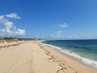
Shenton Park lies on Spearwood Dunes, which formed around 40,000 years ago. The dunes consist of brown sand lying over yellow subsoil, with Tamala Limestone below. These dunes are part of the greater Swan Coastal Plain.[3][4]
Shenton Park is named after George Shenton, who served three terms as Mayor of Perth in the 19th century and owned land in the area.[5]
Demographics
Shenton Park's population at the 2016 Australian census was 4,525,[6] of which almost all are east of the railway line.[7] This population is an increase on the 4,350 recorded at the 2011 census,[8] the 4,195 recorded at the 2006 census,[9] and the 4,163 recorded at the 2001 census.[10] 47.9% of residents were male and 52.1% were female. The median age was 39, above the state average of 36 and the national average of 38.[6]
At the 2016 census, 67.4% of Daglish households were families, below the state average of 72.7%; 27.7% were single person households, above the state average of 23.6%; and 4.9% were group households, above the state average of 3.8%. Of those family households, 35.8% were couples without children, 49.3% were couples with children, 13.0% were a single parent with children, and 1.9% were some other type of family. These figures are all close to the state averages of 38.5%, 45.3%, 14.5% and 1.7% respectively. The average number of people per household was 2.5, slightly below the state average of 2.6.[6]
Out of the suburbs 1,886 dwellings, 1,676 were occupied and 210 were unoccupied at the 2016 census. Out of the occupied dwellings, 67.4% were detached, below the state average of 79.1%; 14.7% were semi detached, close to the state average of 14.1%; and 17.9% were flats or apartments, above the state average of 5.7%, The average number of bedrooms per dwelling was 2.8, below the state average of 3.3. 35.1% of dwellings were owned outright, compared to the state average of 28.5%; 27.8% were owned with a mortgage, compared to the state average of 39.7%; 34.3% were rented, compared to the state average of 28.3%, and 2.7% had some other tenure type or the tenure type was not stated, compared to the state average of 3.7%.[6]
At the 2016 census, the median weekly personal income was $998, compared to the state average of $724 and national average of $662; the median weekly family income was $2,936, compared to the state average of $1,910 and national average of $1,734; and the median weekly household income was $2,196, compared to the state average of $1,595 and the national average of $1,438. Professionals and managers were the most common professions for those employed living in Subiaco, at 47.8% and 14.7% of residents respectively. Clerical and administrative workers were 10.4% of those employed, community and personal service workers were 8.0%, and sales workers were 6.2%. Blue collar jobs were low, with technicians and trades workers at 5.7%, labourers at 4.6%, and machinery operators and drivers at 0.8%. The most common industries of employment were hospitals (except psychiatric hospitals) (9.5%), higher education (6.1%), legal services (3.4%), cafes and restaurants (2.6%), and state government administration (2.5%). 53.4% of residents aged 15 years or above had a bachelor's degree or above, significantly higher than the state average of 20.5%.[6]
The most common ancestries that people identified with at the 2016 census were English (29.7%), Australian (22.1%), Irish (9.2%), Scottish (8.4%), and Chinese (3.9%). 62.3% of residents were born in Australia, slightly higher than the state average of 60.3%. The next most common birthplaces were England (9.6%), Scotland (1.8%), New Zealand (1.5%), the United States (1.5%), and Malaysia (1.4%). 39.7% of residents had both parents born outside Australia, and 38.0% of residents had both parents born inside Australia. The most common religious affiliations were no religion (41.3%), Catholic (17.4%), Anglican (15.4%), and Uniting Church (3.2%). 9.0% of residents did not state their religion.[6]
Parks and amenities
On the western side is Shenton College, a purpose-built high school established in 2000, a teaching and rehabilitation hospital which includes a health science campus of Curtin University of Technology, two private hospitals, the University of Western Australia Shenton Field Station, offices of numerous health advocacy associations and depots and processing plants associated with the Water Corporation and various councils.
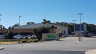
The suburb is the base of Post Newspapers, in Onslow Road, a weekly newspaper that is distributed in Perth's western suburbs.
Shenton Park has two animal welfare organisations opposite each other on Lemnos Street: the Dogs' Refuge Home and the Cat Haven.
During an outbreak of smallpox in 1893, the colonial government set up an isolation tent hospital in the bush at Shenton Park. The facility was home to the Rehabilitation Services and Spinal Unit of Royal Perth Hospital. The hospital has since closed.[citation needed]
Education
Shenton College's learning hub, completed c.2019Shenton College's Borneo House, part of the heritage listed former Lemnos Hospital
East of the railway line, Shenton Park is part of the City of Subiaco. West of the railway line, Shenton Park is part of the City of Nedlands.[2] Within the City of Subiaco, Shenton Park is part of the South Ward.[11] Councillors for the South Ward are Rick Powell, whose term ends in 2023, and Simon White, whose term ends in 2025. The Mayor of Subiaco is David McMullen, whose term ends in 2025.[12] Within the City of Nedlands, Shenton Park is part of the Hollywood Ward.[13] Councillors for the Hollywood Ward are John Wetherall, whose term ends in 2023, and Ben Hodsdon and Olinka Combes, whose terms end in 2025. The Mayor of Nedlands is Fiona Argyle, whose term ends in 2023.[14]
The only voting location in Shenton Park is the Shenton Park Community Centre. Federal elections before 2013 also used St Aloysius Catholic Church for voting as well.
At the 2016 census, 52.1% of Shenton Park residents travelled to work in a car, compared to the state average of 70.4%; 15.7% travelled to work on public transport, compared to the state average of 9.2%; 7.3% walked to work, compared to the state average of 2.8%; and 6.2% cycled to work, compared to the state average of 1.0%.[6]
Road
Major roads in Shenton Park include Aberdare Road, Hay Street, Nicholson Road, Railway Road, Rokeby Road, Selby Street, Stubbs Terrace, and Thomas Street. Thomas Street is a six-lane dual carriageway which travels along Shenton Park's western boundary. To the south, Thomas Street leads to Stirling Highway and the University of Western Australia (UWA). To the north-east, Thomas Street leads to the Perth CBD and the Mitchell Freeway. Hay Street is a four-lane dual carriageway which travels along Shenton Park's northernmost boundary. To the west it leads to West Coast Highway and to the east it leads to the Perth CBD.[2][28]
Aberdare Road and Nicholson Road travel along the northern and southern boundaries of the eastern section of Shenton Park, linking Thomas Street with Railway Road. Nicholson Road passes under the railway at a bridge, connecting to Selby Street, which runs north–south. To the north, it leads to Innaloo and Stirling. To the south, Selby Street leads to Stubbs Terrace, which runs along the north side of the railway to Claremont. On the southern side of the railway is Railway Road, which also leads to Claremont south-west of Shenton Park. Rokeby Road is a road which goes north from Shenton Park, going into the Subiaco town centre.[2][28]
Public transport in Perth is all under the Transperth brand. Train services are operated by Transperth Train Operations, a division of the Public Transport Authority. Bus services in Perth are contracted out to private companies. Subiaco is in the Claremont contract area, which is being operated by Swan Transit.[29]
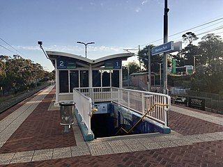
Shenton Park is served by Shenton Park railway station along the Fremantle line, which links the port city of Fremantle with Perth. The bus routes which serve Shenton Park are route 24, 25, 26, 27, 96, 97, 103, 998 and 999.[30] Routes 998 and 999, also known as the CircleRoute, are a pair of bus routes which travel in a circle around Perth. Route 998 is clockwise, and route 999 is anticlockwise. Their route goes through Shenton Park along Aberdare Road, crossing the railway line at a bus only bridge south of Shenton Park station, before going along Stubbs Terrace and Selby Street.[31] The destinations that the other routes link to include Claremont station along the Fremantle line, UWA, Dalkeith and Nedlands to the south, the Perth CBD, East Perth and Leederville railway station along the Yanchep line.[30]
Related Research Articles
Hamersley is a residential suburb 14 kilometres north-northwest of the central business district of Perth, the capital of Western Australia, and six kilometres (4 mi) from the Indian Ocean. The suburb adjoins two major arterial roads—Mitchell Freeway to the west and Reid Highway to the south—and is within the City of Stirling local government area. It was built during the late 1960s and 1970s as part of the Government of Western Australia's response to rapidly increasing land prices across the metropolitan area.
Karrinyup is a suburb of Perth, the capital city of Western Australia, and is located 12 km north of Perth's central business district. Its local government area is the City of Stirling.
The City of Nedlands is a local government area in the inner western suburbs of the Western Australian capital city of Perth, about 7 kilometres (4 mi) west of Perth's central business district. The city is situated within the western suburbs of the metropolitan area—known colloquially as the “golden triangle” for the concentration of wealth and high housing values.
Claremont is a western suburb of Perth, Western Australia, on the north bank of the Swan River.
Subiaco is an inner-western suburb of Perth, the capital of Western Australia. It is approximately 3 km (1.9 mi) west of Perth's central business district, in the City of Subiaco local government area. Historically a working-class suburb containing a mixture of industrial and commercial land uses, since the 1990s the area has been one of Australia's most celebrated urban redevelopment projects. It remains a predominantly low-rise, urban village neighbourhood centred around Subiaco train station and Rokeby Road.
Swanbourne is a western coastal suburb of Perth, Western Australia, located within the City of Nedlands. It is an affluent, upper middle class residential area with older Federation style homes, many being renovated. The suburb was established in the late 19th century. New housing estates have been built recently through the redevelopment of areas such as the Swanbourne Senior High School, Swanbourne Primary School and Lakeway Drive-In Cinema sites.
Shenton Park railway station is a commuter railway station in Shenton Park, a suburb of Perth, Western Australia. The station is on the Fremantle and Airport lines, which are part of the Transperth public transport network. It has an island platform, accessed by a pedestrian underpass. The station is only partially accessible due to a steep ramp. Services on each line run every 12 minutes during peak hour and every 15 minutes outside peak hour and on weekends and public holidays. At night, trains are every half-hour or hour. The journey to Perth railway station is 6.0 kilometres (3.7 mi), and takes 9 minutes.
Daglish railway station is a commuter railway station on the boundary of Daglish and Subiaco, suburbs of Perth, Western Australia. Opened on 14 July 1924, the station was named after Henry Daglish, who had been a mayor of Subiaco, a member for the electoral district of Subiaco, and a premier of Western Australia in the 1900s. Daglish was a resident of Subiaco for 22 years before he died in 1920. The station consists of an island platform accessed by a pedestrian underpass. Two small buildings are on the platform which operated as a parcels office and ticket office until 1970. The station is only partially accessible due to a steep access ramp and lack of tactile paving.
Kardinya is a suburb 13 kilometres (8 mi) south-southwest of the central business district of Perth, the capital of Western Australia. It is in the City of Melville local government area. It is predominantly a low-density residential suburb consisting of single-family detached homes. There is a commercial area in the centre of the suburb, with a shopping centre and several other shops. In the northwest is a small light industrial area. Kardinya has a population of 8,730 people.
Bedford is a suburb 6 kilometres (4 mi) north-east of the central business district (CBD) of Perth, the capital of Western Australia. Named after Frederick Bedford, the Governor of Western Australia from 1903 to 1909, the suburb is within the City of Bayswater local government area. It is predominantly a low density residential suburb consisting of single-family detached homes, with clusters of commercial buildings along Beaufort Street, Grand Promenade and Walter Road.
Wembley is a western suburb of Perth, Western Australia, located within the Town of Cambridge. Its postcode is 6014.
Clarkson is an outer northern suburb of Perth, Western Australia, located 34 kilometres north of Perth's central business district in the City of Wanneroo.
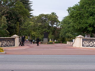
Karrakatta is a suburb of Perth, Western Australia, located within the City of Nedlands and 7 km west of the central business district. Its postcode is 6010.
Jolimont is a small western suburb of Perth, Western Australia, located within the City of Subiaco, although a small portion of the suburb is administered by the Town of Cambridge west of the CBD. The suburb is believed to be named after the Melbourne suburb of Jolimont, which was in turn named after "Jolimont" - the residence of Governor La Trobe. Its postcode is 6014.
Daglish is a small western suburb of Perth, the capital of Western Australia. It is approximately 4 kilometres (2.5 mi) west of the Perth central business district, and within the City of Subiaco local government area. It was named after Henry Daglish, who was the mayor of Subiaco, member for the electoral district of Subiaco and premier of Western Australia from 1904 to 1905. The Daglish railway station opened in 1924 in response to population growth in the neighbouring suburb of Subiaco. The following year, the Municipality of Subiaco bought the land west of the railway station to sell for housing. Development occurred over the following 20 years. The initial development next to the railway station used the garden suburb principles, with large lots and gardens, curved streets, and lots of green space. Today, the suburb has significant heritage value due to its uniform streetscape, with most original homes still standing. It has a population of 1,419 as of the 2016 Australian census.
The City of Perth is a local government area and body, within the Perth metropolitan area, which is the capital of Western Australia. The local government is commonly known as Perth City Council. The City covers the Perth city centre and surrounding suburbs. The City covers an area of 20.01 square kilometres (8 sq mi) and had an estimated population of 21,092 as at 30 June 2015. On 1 July 2016 the City expanded, absorbing 1,247 residents from the City of Subiaco.
Bouvard is the second southernmost suburb of Mandurah, Western Australia, and is 97 kilometres (60 mi) south of the state capital, Perth. Its local government area is the City of Mandurah.
Nedlands is a Legislative Assembly electorate in the state of Western Australia. Nedlands is named for the inner western Perth suburb of Nedlands, which falls within its borders.
Nedlands is a western suburb of Perth, the capital city of Western Australia. It is a part of the local government areas of the City of Nedlands and the City of Perth. It is about 7 kilometres (4 mi) from the Perth CBD via either Thomas Street or Mounts Bay Road.
Bayswater is a suburb 6 kilometres (4 mi) north-east of the central business district (CBD) of Perth, the capital of Western Australia. It is just north of the Swan River, within the City of Bayswater local government area. It is predominantly a low-density residential suburb consisting of single-family detached homes. However, there are several clusters of commercial buildings, most notably in the suburb's town centre, around the intersection of Whatley Crescent and King William Street and a light industrial area in the suburb's east.
This page is based on this Wikipedia article Text is available under the CC BY-SA 4.0 license; additional terms may apply. Images, videos and audio are available under their respective licenses.