Thomas Street, Perth

Last updated

Thomas Street

Thomas Street, Perth
General information
TypeRoad
Length3.3 km (2.1 mi)
Route number(s)
Tourist routes Tourist Drive 200 (Kings Park)
Major junctions
Southwest endAustralian state route 61.svgAustralian Tourist Drive 200.svg Winthrop Avenue (State Route 61 / Tourist Drive 200), Shenton Park
 
  • Australian state route 64.svg Rokeby Road (State Route 64)
  • Australian Tourist Drive 200.svg Kings Park Road (Tourist Drive 200)
  • Australian state route 65.svg Hay Street (State Route 65)
  • Australian state route 65.svg Roberts Road (State Route 65)
  • Australian state route 65.svg Wellington Street (State Route 65)
Northeast endAustralian state route 61.svg Loftus Street (State Route 61), West Leederville
Location(s)
Major suburbs Subiaco, West Perth

Thomas Street is a major northeast-southwest road in the Perth suburbs of Subiaco and West Perth , connecting Winthrop Avenue with Loftus Street. These roads, together with London Street further north, form State Route 61, [1] which links Crawley with West Perth and Yokine.

Contents

History

The road is named after James Thomas, the Director of Public Works 1876 to 1884. [2] [3]

A railway station, to be located at the corner of Thomas Street and Subiaco Road, was proposed in 1892. [4] [5] There were mixed responses from the public, [6] [7] but the construction costs would have been too expansive due to the steep grade. [8] [9] [10] An alternative site was selected nearby, at Kimberley Street. [10] West Leederville railway station opened there on 12 July 1897. [11]

In 1939, there were calls for the road to be rebuilt and upgraded to dual carriageway standard in the vicinity of Kings Park. [12] In 1940, a plan for construction of the second carriageway was announced by the King's Park Board, the Perth City Council and the Subiaco Municipal Council. [13] The councils would be jointly responsible for the building of the road, with the King's Park Board responsible for the clearing of vegetation. [13] The resumption of a strip of land along the edge of the park needed for the works was approved by an Act of Parliament. [13]

Route description

Thomas Street's southern terminus is a traffic light controlled intersection with Winthrop Avenue and Aberdare Road in Shenton Park, at the north-eastern corner of the Queen Elizabeth II Medical Centre, where Sir Charles Gairdner Hospital is located. The road follows the edge of Kings Park for 2.1 kilometres (1.3 mi) as a six lane dual carriageway, heading in a north-easterly direction to West Perth. North of Kings Park, Thomas Street narrows to a four lane single carriage, with a narrow median strip. It forms the boundary between Subiaco to the west and West Perth to the east of the road. After 600 metres (2,000 ft), the street passes by Princess Margaret Hospital, located between Hay Street and Roberts Road. This section is also part of State Route 65 westbound. The road's northern terminus is situated 600 metres (2,000 ft) further northeast, at its intersection with Loftus Street and Railway Parade. The major intersections along the road are controlled by traffic lights, with the exception of Murray Street. [14] [15]

Major intersections

All intersections listed are controlled by traffic lights unless otherwise indicated.

LGALocationkmmiDestinationsNotes
Cambridge-Perth-Subiaco tripoint West Leederville-West Perth-Subiaco tripoint00.0Railway Parade westbound / Railway Street eastbound   Subiaco, Wembley, Northbridge Northern terminus. Continues as Australian state route 61.svg Loftus Street (State Route 61) northbound.
Perth-Subiaco boundary West Perth-Subiaco boundary0.30.19Australian state route 65.svg Roberts Road westbound / Wellington Street eastbound (State Route 65)   Perth, East Perth Roberts Road one-way eastbound, no movements permitted from either Thomas or Wellington Street.
0.50.31 Murray Street   Perth, East Perth Unsignalised intersection, Murray Street one-way eastbound.
0.60.37Australian state route 65.svg Hay Street (State Route 65)   Subiaco, Floreat, Mount Claremont Hay Street one-way westbound.
West Perth-Kings Park-Subiaco tripoint1.10.68Bagot Road westbound / Australian Tourist Drive 200.svg Kings Park Road eastbound (Tourist Drive 200)   Subiaco, Perth Tourist Drive 200 northern concurrency terminue. No right turn from Thomas Street southbound to Bagot Road or Bagot Road to Thomas Street southbound.
Perth-Nedlands boundary Kings Park-Shenton Park boundary2.41.5Australian state route 64.svg Rokeby Road (State Route 64) northbound / Saw Avenue southbound   Subiaco
Kings Park-Nedlands-Shenton Park tripoint3.32.1Western Australia MR-SM-1.svg Aberdare Road west   Karrakatta , Queen Elizabeth II Medical Centre Southern terminus. Continues as Australian state route 61.svgAustralian Tourist Drive 200.svg Winthrop Avenue (State Route 61, Tourist Drive 200) southbound.
1.000 mi = 1.609 km; 1.000 km = 0.621 mi
Note: Intersections with minor local roads are not shown

See also

Australia road sign W5-29.svg   Australian roadsportal

Related Research Articles

<span class="mw-page-title-main">Subiaco, Western Australia</span> Suburb of Perth, Western Australia

Subiaco is an inner-western suburb of Perth, the capital of Western Australia. It is approximately 3 km (1.9 mi) west of Perth's central business district, in the City of Subiaco local government area. Historically a working-class suburb containing a mixture of industrial and commercial land uses, since the 1990s the area has been one of Australia's most celebrated urban redevelopment projects. It remains a predominantly low-rise, urban village neighbourhood centred around Subiaco train station and Rokeby Road.

<span class="mw-page-title-main">Graham Farmer Freeway</span> Freeway in Perth, Western Australia

Graham Farmer Freeway is a 6.4-kilometre (4.0 mi) inner-city freeway in Perth, Western Australia. It links Rivervale and Burswood with West Perth and Leederville, providing an east-west bypass of Perth's central business district.

The Mitchell Freeway is a 41.6-kilometre-long (25.8 mi) freeway in the northern suburbs of Perth, Western Australia, linking central Perth with the city of Joondalup. It is the northern section of State Route 2, which continues south as Kwinana Freeway and Forrest Highway. Along its length are interchanges with several major roads, including the Graham Farmer Freeway and Reid Highway. The southern terminus of the Mitchell Freeway is at the Narrows Bridge, which crosses the Swan River, and the northern terminus is at Romeo Road in Alkimos, a suburb within the City of Wanneroo.

<span class="mw-page-title-main">West Leederville railway station</span> Railway station in Perth, Western Australia

West Leederville railway station is on the Transperth network in Western Australia. It is located on the Fremantle line and Airport line, 2.7 kilometres from Perth station on the boundary between West Leederville and Subiaco. It was the main station for the former Subiaco Oval containing a special event platform no longer in use.

Shenton Park is a suburb of Perth, Western Australia, located within the City of Nedlands and City of Subiaco and 4 km (2.5 mi) west of the central business district. Its postcode is 6008. The suburb is named after the park that it contains, Shenton Park, which was named after George Shenton who originally owned the land that is now the suburb of Shenton Park.

<span class="mw-page-title-main">Wanneroo Road</span> Road in Perth, Western Australia

Wanneroo Road is a 44-kilometre (27 mi) arterial highway in the northern suburbs of Perth, Western Australia linking Joondanna and Yokine in the south with Wanneroo and Yanchep in the north. As part of State Route 60, it begins from Charles Street in the inner city and becomes Indian Ocean Drive up to Dongara.

<span class="mw-page-title-main">Reid Highway</span> Highway in Perth, Western Australia

Reid Highway is a 23-kilometre (14 mi) east-west highway and partial freeway in the northern suburbs of Perth, Western Australia, linking North Beach with Middle Swan. As part of State Route 3, it forms half of Perth's outer ring road along with Roe Highway, which it joins onto at its eastern terminus.

<span class="mw-page-title-main">Leach Highway</span> Highway in Perth, Western Australia

Leach Highway is a 23-kilometre (14 mi) east-west arterial highway in the southern suburbs of Perth, Western Australia, primarily linking Kewdale and Perth Airport with the city of Fremantle.

<span class="mw-page-title-main">Hay Street, Perth</span> Street in Perth, Western Australia

Hay Street is a major road through the central business district of Perth, Western Australia and adjacent suburbs. The street was named after Robert William Hay, the Permanent Under Secretary for Colonies. Sections of the road were called Howick Street and Twiss Street until 1897. One block in the central business section is now a pedestrian mall with extremely limited vehicular traffic, so that it is necessary to make a significant detour in order to drive the entire length of Hay Street.

<span class="mw-page-title-main">Alexander Drive</span> Road in Perth, Western Australia

Alexander Drive is a major north–south arterial road in the northern suburbs of Perth, Western Australia, connecting Perth's central business district (CBD) with Edith Cowan University's Mount Lawley campus and the Malaga industrial area, as well as newer development suburbs to Perth's north. It is used by Transperth bus routes, including the 360, 361 and 362. Alexander Drive was named after Mr S.B. Alexander, a former Wanneroo Road Board member. Alexander Drive runs through the following local government areas City of Wanneroo, City of Swan, City of Bayswater and City of Stirling.

<span class="mw-page-title-main">Beach Road, Perth</span> Road in Perth, Western Australia

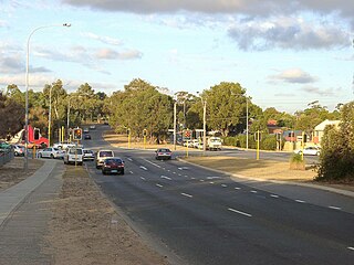
Beach Road is a major east-west road in the northern suburbs of Perth, Western Australia, connecting Perth's inner northern beachside suburbs and inland state housing areas with shopping and public transport facilities at Warwick and the Malaga industrial area. It was mostly built between 1967 and 1974, and is a dual carriageway for most of its length, except for a small western part between Marmion Avenue and the coast, which is a minor residential distributor road and is discontinuous at Marmion Avenue. Beach Road also serves as a local government boundary. From Alexander Drive to Wanneroo Road, Beach Road is the boundary with the City of Wanneroo on the northern side and the City of Stirling on the southern side. From Wanneroo Road to the coast Beach Road is the boundary with the City of Joondalup on the northern side and the City of Stirling on the southern side.

<span class="mw-page-title-main">Beaufort Street</span> Road in Perth, Western Australia

Beaufort Street is a major road in the inner north-eastern suburbs of Perth, Western Australia, connecting the Morley area to the Perth central business district. For most of its length, it is a single-carriageway, two-way road with two lanes in each direction.

<span class="mw-page-title-main">Queen Victoria Street, Fremantle</span> Road in Fremantle, Western Australia

Queen Victoria Street is the main road entering the city centre of Fremantle, Western Australia from the direction of Perth. The road was originally named Cantonment Road, but was subsequently renamed Victoria Road, and a few years later Queen Victoria Street, after Queen Victoria of the United Kingdom, to avoid confusion with similarly named roads in the area.

<span class="mw-page-title-main">Scarborough Beach Road</span> Road in Perth, Western Australia

Scarborough Beach Road is an arterial northwest–southeast road located in the inner northern suburbs of Perth, Western Australia. It connects North Perth to Scarborough Beach, and is mostly a single carriageway road, with two or three lanes in each direction. The road is the western section of State Route 75, between Osborne Park and Scarborough, and a short section in Innaloo is also part of State Route 64.

<span class="mw-page-title-main">Mounts Bay Road</span> Road in Perth, Western Australia

Mounts Bay Road is a major road in Perth, Western Australia, extending southwest from the central business district along the north bank of the Swan River, at the base of Kings Park.

<span class="mw-page-title-main">Trams in Perth</span> Tramway Network in Perth

The Perth tramway network served Perth, the capital city of Western Australia, from 1899 until 1958. The network was initially run by a private company but was taken over by the state government in 1913. From a single line along Hay Street, the network expanded north as far as Osborne Park, east as far as Welshpool, south as far as Como, and west as far as Claremont. The tramways were gradually replaced by buses after World War II.

<span class="mw-page-title-main">Winthrop Avenue</span> Road in Perth, Western Australia

Winthrop Avenue is a major north–south road in the Perth suburbs of Nedlands and Crawley. For most of its length, the road travels alongside the south-western edge of Kings Park, connecting Thomas Street with Stirling Highway, Mounts Bay Road, and the University of Western Australia's Crawley campus. It is the southernmost section of State Route 61, which links Crawley with West Perth and Yokine.

<span class="mw-page-title-main">High Street, Fremantle</span> Street in Fremantle, Western Australia

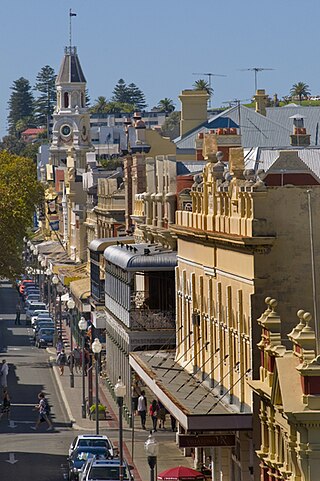
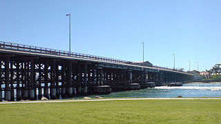
High Street is the main street running through the City of Fremantle, Western Australia. The street passes by historic landmarks, including the Round House, the Fremantle Town Hall, and the Fremantle War Memorial, through the Fremantle West End Heritage area and through two town squares. Trams operated along High Street for 47 years, between 1905 and 1952. Running east–west, High Street continues as Leach Highway, a major arterial road, at Stirling Highway, linking Fremantle with Perth Airport although the stretch of road between Stirling Highway and Carrington Street is known locally—and signed—as High Street.

Loftus Street is a major north-south road in the Perth suburbs of Subiaco and West Perth, connecting London Street with Thomas Street. These roads, together with Winthrop Avenue further south, form State Route 61, which links Crawley with West Perth and Yokine.

<span class="mw-page-title-main">The Boulevard, Perth</span> Road in Perth, Western Australia

The Boulevard is a 5-kilometre (3.1 mi) distributor road in the western suburbs of Perth, Western Australia, linking the inner western suburb of Wembley to City Beach on the west coast. The section of The Boulevard west of Floreat is the westernmost section of State Route 72, which continues east as Grantham Street to Wembley and beyond. Along its route are intersections with several major roads, including Selby Street and Grantham Street. The eastern terminus of The Boulevard is at Cambridge Street and the western terminus is at West Coast Highway.

References

  1. Distance book (12 ed.). Main Roads Western Australia. 2012. pp. 4–5. ISBN   0 7309 7657 2. Archived from the original on 24 October 2012. Retrieved 8 October 2012.
  2. "Street Names" (PDF). City of Subiaco. Archived from the original (PDF) on 13 April 2013. Retrieved 31 October 2012.
  3. Institution of Civil Engineers (Great Britain) (1885), Excerpt, Minutes of proceedings of the Institution of Civil Engineers, vol. lxxx, session 1884-85, part ii, The Institution, retrieved 8 December 2012
  4. "DEPUTATIONS TO THE PREMIER". The West Australian . Perth: National Library of Australia. 14 July 1892. p. 3. Retrieved 8 December 2012.
  5. "NEWS AND NOTES". The West Australian . Perth: National Library of Australia. 14 July 1892. p. 4. Retrieved 8 December 2012.
  6. "CORRESPONDENCE". Western Mail . Perth: National Library of Australia. 23 July 1892. p. 2. Retrieved 8 December 2012.
  7. "NEWS AND NOTES". The West Australian . Perth: National Library of Australia. 17 August 1895. p. 5. Retrieved 8 December 2012.
  8. "THE NORTH PERTH RAILWAY STATION". The West Australian . Perth: National Library of Australia. 26 June 1893. p. 3. Retrieved 8 December 2012.
  9. "THE MIDLAND RAILWAY COMPANY OF WESTERN AUSTRALIA". The Inquirer & Commercial News . Perth: National Library of Australia. 30 June 1893. p. 23. Retrieved 8 December 2012.
  10. 1 2 "STATION SITE AT LEEDERVILLE". The Daily News . Perth: National Library of Australia. 29 February 1896. p. 7. Retrieved 8 December 2012.
  11. "WESTERN AUSTRALIAN GOVERNMENT RAILWAYS". The West Australian . Perth: National Library of Australia. 16 July 1897. p. 3. Retrieved 8 December 2012.
  12. "KING'S PARK". The West Australian . Perth: National Library of Australia. 1 August 1939. p. 15. Retrieved 17 November 2012.
  13. 1 2 3 "KING'S PARK". The West Australian . Perth: National Library of Australia. 27 September 1940. p. 9. Retrieved 17 November 2012.
  14. 2011 UBD Perth and Surrounds Street Directory. Australia: Universal Publishers Pty Ltd. 2011. pp. Maps 268, 287. ISBN   978 0 7319 2653 4.
  15. Google (8 December 2012). "Thomas Street, Perth" (Map). Google Maps . Google. Retrieved 8 December 2012.
Template:Attached KML/Thomas Street, Perth
KML is from Wikidata