Perth railway station

Last updated

Perth
Perth 220716 gnangarra-9.JPG
View of the station from platform 5
General information
Location Wellington Street, Roe Street
Perth, Western Australia
Australia
Coordinates 31°57′05″S115°51′37″E / 31.95139°S 115.86028°E / -31.95139; 115.86028
Owned by Public Transport Authority
Operated by Transperth Train Operations
Line(s)
Platforms9 (3 side above ground, 2 islands above ground, 1 island below ground)
Tracks9
Bus routes20
ConnectionsBus transfer at Perth Busport, Wellington Street, and William Street Mandurah and Butler services at Perth Underground
Construction
Structure typeGround & underground
Platform levels2
ParkingNo
Bicycle facilitiesYes
AccessibleYes
Architectural style Neoclassical
Other information
StatusStaffed
Station codeMPH
Fare zone1 / Transperth Free Transit Zone.svg
History
Opened1 March 1881
ElectrifiedYes
Passengers
201738,159 daily [1]
Services
Preceding station Transperth icon.svg Transperth Following station
Terminus Joondalup line
PW
Leederville
towards Whitfords
Armadale line
All, B, C
McIver
towards Armadale
Thornlie line
T
McIver
towards Thornlie
through to Fremantle line Midland line McIver
towards Midland
through to Midland line Fremantle line City West
towards Fremantle
City West
towards Claremont
Airport line McIver
towards High Wycombe
Terminus Airport line
P
Perth Underground
through to Joondalup line Mandurah line
All, K, W
Elizabeth Quay
Elizabeth Quay
Terminus
Joondalup line
All, K, W
Leederville
Opening in 2024
Terminus Morley–Ellenbrook line McIver
towards Ellenbrook
Preceding station Transwa icon v2.svg Transwa Following station
Terminus Australind Armadale
towards Bunbury
Official namePerth Railway Precinct
TypeState Registered Place
Designated28 August 2001
Reference no. 2133
Location
Perth railway station
Location of Perth railway station

Perth railway station is the largest station on the Transperth network, serving the central business district of Perth, Western Australia. It serves as an interchange between the Airport, Armadale, Fremantle, Midland, and Thornlie lines as well as Transwa's Australind service. It is also directly connected to Perth Underground railway station, which has the Joondalup line and Mandurah line.

Contents

History

Establishment

The station in 1921 PerthrailwayStation.jpg
The station in 1921

The foundation stone for the original Richard Roach Jewell-designed Perth station was laid on 10 May 1880, with the station opening on 1 March 1881 as part of the Eastern Railway from Fremantle to Guildford. [2] [3] [4] The station had one through platform with a terminating dock platform at the east end; however it soon proved to be inadequate for the growing railway, and after the opening of the Armadale line in 1889 put further stress on the facility it was decided that a larger station would be built. [5]

The new, larger Victorian Free Classical style station building, designed by George Temple-Poole, was opened south of the original station in 1894, with the old building demolished and replaced by a new island platform. [5] The new station building, still in use today, has been expanded numerous times since being built, including the addition of two wings at the east and west ends of the building. A planned third storey and clocktower were never built. [6] [7] A collection of freight and administrative offices and tearooms were also part of the railway station complex. The station initially had the Barrack Street and William Street bridges as limiting factors to its further development, though platforms to the west of the station that ran underneath the Horseshoe Bridge were eventually constructed.

The station was the centre of the Western Australian Government Railways system, with most regional trains originating from the station, and it also served as the headquarters of the agency until 1976. [8] Following the cessation of most regional passenger services, the completion of standard gauge tracks to East Perth station, and the relocation of most administrative offices to the Westrail Centre, by the late 1970s Perth station remained only as a terminus for The Australind service to Bunbury, as well as an interchange for Transperth's suburban services.

The railway building has at times housed various commercial operations as well as police offices. The WA Craft Council was a tenant in the 1980s. [9] For a considerable length of time the forecourt area was used for car parking, though this is no longer the case.

Later development

Wellington Street entrance in March 2005 Transperth Perth Train Station.jpg
Wellington Street entrance in March 2005

As early as the 1950s, there were moves and suggestions for the redevelopment of the station area. [10] Starting in 1988 the station underwent a major upgrade as part of the Northern Suburbs Transit System project, which included the construction of a new island platform, a steel and glass roof that covered the central platforms, an adjoining multi-storey car park, and the Citiplace Centre retail and community services hub built on a level above the existing station platforms which also connected pedestrian footbridges linking the Perth Cultural Centre and the Forrest Chase shopping complex to the station. [5]

In 1992, a ninth platform was added along with a pedestrian overpass at the extreme west end of the station which allowed direct access to the railway station from Wellington Street bus station and Northbridge. [11] With the introduction of the SmartRider contactless electronic ticketing system and installation of fare gates, Perth railway station became a closed station in early 2007; [12] as a result the entrance on the Horseshoe Bridge was fenced off and its wooden stairway and overpass was later removed. [13]

As part of the New MetroRail project, the station was refurbished and expanded with new underground platforms built at a 90-degree angle to the existing platforms beneath Gordon Stephenson House to the east of William Street, between Wellington and Murray Streets. The underground platforms, numbered 1 and 2, are known as Perth Underground, but are in some aspects considered part of the overall Perth station. The underground platforms are linked to the original Perth station via a walkway under Wellington Street; a new entrance to Perth Underground was also constructed at the west end of the Murray Street pedestrian mall. The new platforms opened on 15 October 2007. [14] [15]

Further changes to the station occurred as part of the Perth City Link project in the early-2010s, which saw the above ground rail lines west of the Horseshoe Bridge sunk and the existing platforms and overpass there demolished to make way for a new public space, Yagan Square. This reduced the above ground platforms from nine to seven. The station also saw the construction of a new pedestrian underpass connecting the three main above ground platforms, and upgrades and extensions to the roof. [13] [16] [17]

In September 2013, a new Platform 9 on the Roe Street side of the station opened. [18] This new platform was temporarily used for special event services until mid-December 2013, before becoming part of the Midland line. [19]

In 2022 and 2023, the forecourt of the station underwent refurbishment in order to improve amenity and visitor safety. [20]

Plaques formerly in entrance area to station

The railway station entrance area had plaques to commemorate the following events:

Platforms and services

Perth station
Track layout and
surrounding railyard
BSicon MFADEg.svg
BSicon vSTR.svg
BSicon MFADEg.svg
BSicon vSTR.svg
BSicon vSTRgf.svg
BSicon vSTRgf.svg
BSicon v-2SHI2r.svg
BSicon dSTR.svg
BSicon vUSTl.svg
BSicon v-ENDEa.svg
BSicon v2SHI2+l-.svg
BSicon vUSTl.svg
BSicon v2SHI2l-.svg
BSicon v-STR.svg
BSicon vUSTl.svg
BSicon v2SHI2l-.svg
BSicon v-2SHI2+r;g2.svg
BSicon dSTRc3.svg
BSicon v-2SHI2r.svg
BSicon v2SHI2l-.svg
BSicon dSTR.svg
BSicon ABZg2.svg
BSicon v-2SHI2+r.svg
BSicon cSTRc3.svg
BSicon STRc1.svg
BSicon v-SHI2gr.svg
BSicon dKSTR2.svg
BSicon dSTR+4.svg
BSicon STRc3.svg
BSicon v2SHI2+l-.svg
BSicon v-2SHI2g+r.svg
BSicon vSTR.svg
BSicon cSTRc1.svg
BSicon STR~L.svg
BSicon ABZg+4.svg
BSicon cSTR~R.svg
BSicon dSTR+c1.svg
BSicon STR+4.svg
BSicon vSTR-PLT.svg
BSicon vSTR.svg
BSicon vPLT-STR.svg
BSicon vSTR.svg
BSicon PSTR.svg
BSicon vSTR-PLT.svg
BSicon vSTR.svg
BSicon vPLT-STR.svg
BSicon vSTR.svg
3
BSicon PSTR.svg
BSicon vSTR-PLT.svg
BSicon vSTR.svg
BSicon vPLT-STR.svg
BSicon vSTR.svg
4
BSicon PSTR.svg
BSicon vSTR-PLT.svg
BSicon vSTR.svg
BSicon vPLT-STR.svg
BSicon vSTR-ENDEe.svg
BSicon v-PLT+v-PLTq.svg
BSicon PENDEe(LR).svg
8
BSicon vSTR-PLT.svg
BSicon vSTR.svg
6
BSicon vPLT-STR.svg
BSicon vSTR-PLT.svg
9
BSicon vSTR-PLT.svg
BSicon vSTR.svg
7
BSicon vPLT-STR.svg
5
BSicon vSTR-PLT.svg
BSicon vSTR-PLT.svg
BSicon vSTR.svg
BSicon vPLT-STR.svg
BSicon vSTR-PLT.svg
BSicon vSTR-PLT.svg
BSicon vSTR.svg
BSicon vPLT-STR.svg
BSicon vSTR-PLT.svg
BSicon vSTR-PLT.svg
BSicon vSTR.svg
BSicon vPLT-STR.svg
BSicon v-PLT.svg
BSicon vENDEe-.svg
BSicon tvSTR2a-@g.svg
BSicon tdSTRa@g.svg
BSicon tdSTRc3.svg
BSicon tdSTRa@g.svg
BSicon tdSTRa@g.svg
BSicon tSTRc1.svg
BSicon tvUSTr.svg
BSicon tvABZg+4-.svg
BSicon tcSTRc2.svg
BSicon tSTR3.svg
BSicon tcSTR~L.svg
BSicon tABZg+1.svg
BSicon tSTR~R.svg
BSicon tcdSTRc4.svg
BSicon tSHI1c2q.svg
2
BSicon tSTR~Rq.svg
BSicon MFADEfq.svg
BSicon tSTR~Rq.svg
BSicon tkvSTRc2.svg
BSicon tkvKRZ3+lvto.svg
BSicon tvSTRq.svg
BSicon tvSHI1rq-SHI1lq.svg
BSicon tSTR~Lq.svg
BSicon tSTR~Rq.svg
BSicon PLTmmq.svg
BSicon tSTR~Lq.svg
BSicon tSTR~Rq.svg
BSicon MFADEfq.svg
BSicon PLTmmq.svg
BSicon tkvSTR+1.svg
BSicon tkvKRZ-c4.svg
BSicon tvSTR.svg
BSicon tSHI1c1q.svg
1
BSicon tSTR~Lq.svg
BSicon MFADEfq.svg
BSicon tSTR~Lq.svg
BSicon tvUSTl.svg
BSicon tvUSTr.svg
BSicon vNULgf.svg
BSicon tvSTRe@g.svg
BSicon vNULgf.svg
BSicon tvSTRe@g.svg
BSicon dSTR.svg
BSicon vUST.svg
BSicon dSTR.svg
BSicon vUSTr.svg
BSicon vSTR.svg
BSicon vPORTAL@f.svg
BSicon vCSTRa.svg
BSicon vUSTl.svg
BSicon MFADEf.svg
BSicon tvSTR.svg
BSicon MFADEf.svg
BSicon vSTR.svg
Source [21]
View of old Platform 2, now Platform 5 Perth station platform2.jpg
View of old Platform 2, now Platform 5

Platforms currently in use are as follows:

Perth Underground station platforms [22] [23] [24]
StopPlatformLineStopping patternDestinationNotes
996011 Joondalup All stations Butler
K Clarkson Pattern K only operates on weekdays. [23]
W Whitfords Pattern W only operates on weekdays. [23]
996022 Mandurah All stations Mandurah
K Rockingham Pattern K only operates on weekdays. [24]
W Cockburn Central Pattern W only operates on weekdays. [24]
Main platforms [25] [26] [27] [28]
StopPlatformLineStopping patternDestinationNotes
954993 Australind All stations Bunbury Transwa service. [29] [30]
990044 Thornlie All stations Victoria Park [26]
990055 Armadale All stations Victoria Park [26]
999066
990077 Fremantle All stations, S Fremantle [28]
S+ Showgrounds Pattern deviations to stop at Showgrounds.
Airport W Claremont [ citation needed ]
999088 Midland All stations Midland Services coming from Fremantle tunnel arrive at this platform, proceeding to Midland [27] [31]
Airport All Stations, P High Wycombe [ citation needed ]
990099 Midland Midland Special service platform
Joondalup PTerminatesPattern P operates once per weekday, after the morning peak. [23] [32]

It received Airport line services on 9 October 2022. [33] [34]

Perth Underground Murray Street entrance Perth Underground from Murray St evening peak.jpg
Perth Underground Murray Street entrance

Several Transperth bus routes stop adjacent to Perth station. Buses also operate from the nearby Perth Busport, and rail replacement services also depart from the nearby Perth Busport. As of August 2023, Wellington Street has been upgraded to include eleven bus stands outside the station, seven eastbound and four westbound.

StopRouteDestination / descriptionNotes
Beaufort Street/CAT ID 41 Blue CAT to Perth Busport via Northbridge [35] [35]
Stand 167, 68to Mirrabooka bus station
901Rail Replacement to Midland Station In use when Midland Line is out of action
Stand 238to Cloverdale
51to Cannington Bus Station
960to Curtin University bus station High Frequency
902Rail Replacement to High Wycombe station In use when Airport Line is out of action
905Rail Replacement to Victoria Park Station In use when Armadale and Thornlie Lines are out of action
Stand 3220to Armadale station
221to Armadale Station Limited Stops
230to Thornlie Station Limited Stops
Stand 4907to Armadale Station High Frequency, Limited Stops
Stand 5/CAT ID 672 Red CAT to Matagarup Bridge [35]
3 Yellow CAT to Claisebrook station [35]
Stand 641to Bayswater Station
42, 43to Maylands Maylands Boat Ramp
40, 66, 950 and 980to Morley bus station 66 - Limited Stops, 950 and 980 - High Frequency
Stand 7TransWAto Bunbury Australind Rail Replacement
Stand 8/CAT ID 582 Red CAT to West Perth [35]
Stand 9/CAT ID 1453 Yellow CAT to West Perth [35]
Stand 1040, 41, 42, 43, 66 and 980to Elizabeth Quay bus station 66 - Limited Stops 980 - High Frequency
950to Queen Elizabeth II Medical Centre via Elizabeth Quay bus station High Frequency
Stand 1138, 51, 67, 68, 220, 221, 230 and 907to Perth Busport
960to Mirrabooka bus station via Perth Busport High Frequency

Related Research Articles

<span class="mw-page-title-main">Armadale line</span> Suburban rail line in Perth, Western Australia

The Armadale line is a suburban railway service in Perth, Western Australia, operated by the Public Transport Authority as part of the Transperth system. The Armadale line is 30.4 kilometres (18.9 mi) long, and starts at Perth station, heading south-east of there to serve Perth's south-eastern suburbs, terminating at Armadale station.

<span class="mw-page-title-main">McIver railway station</span> Railway station in Perth, Western Australia

McIver railway station is a railway station on the Transperth network in Perth, Western Australia. It is located on the Airport, Armadale, Midland and Thornlie lines, 0.9 kilometres (0.56 mi) from Perth station, providing access to Royal Perth Hospital.

<span class="mw-page-title-main">Claisebrook railway station</span> Railway station in Perth, Western Australia

Claisebrook railway station is a railway station on the Transperth network. It is located on the Armadale line, Thornlie line, Midland line, and Airport line, 1.3 kilometres from Perth station serving the suburb of East Perth.

<span class="mw-page-title-main">Armadale railway station, Perth</span> Railway station in Perth, Western Australia

Armadale railway station is located on the South Western Railway, 30 kilometres from Perth station serving the suburb of Armadale, Brookdale and Haynes. It is the terminating point for Transperth Armadale line services and a calling point for Transwa Australind services.

<span class="mw-page-title-main">Sherwood railway station, Perth</span> Railway station in Perth, Western Australia

Sherwood railway station is a suburban railway station in Armadale, a suburb of Perth, Western Australia. It is on the Armadale line which is part of the Transperth network, and is 28.6 kilometres (17.8 mi) southwest of Perth station and 1.8 kilometres (1.1 mi) north of Armadale station. The station opened in 1973 as Kingsley, but was renamed to Sherwood in 1993. It consists of two side platforms with a pedestrian level crossing. It is not fully accessible due to steep ramps, wide gaps at the pedestrian level crossing, and wide gaps between the platform and train. Services are operated by Transperth Train Operations, a division of the state government's Public Transport Authority. Peak services reach seven trains per hour in each direction, whilst off-peak services are four trains per hour.

<span class="mw-page-title-main">Challis railway station</span> Railway station in Perth, Western Australia

Challis railway station is a suburban railway station in Kelmscott, a suburb of Perth, Western Australia. It is on the Armadale line which is part of the Transperth network, and is 27.3 kilometres (17.0 mi) southwest of Perth station and 3.1 kilometres (1.9 mi) north of Armadale station. The station opened on 29 October 1973, as did the adjacent Sherwood station, filling the large gap between Armadale station and Kelmscott station. It consists of two side platforms with a pedestrian level crossing. It is not fully accessible due to steep ramps and wide gaps at the pedestrian level crossing.
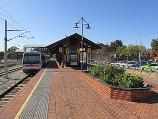
<span class="mw-page-title-main">Seaforth railway station</span> Railway station in Perth, Western Australia

Seaforth railway station is a suburban railway station in Gosnells, a suburb of Perth, Western Australia. It is on the Armadale line which is part of the Transperth network, and is 22.6 kilometres (14.0 mi) southwest of Perth station and 7.8 kilometres (4.8 mi) north of Armadale station. The station opened on 4 May 1948 with low level platforms. High level platforms were added in 1968. The station consists of two side platforms with a pedestrian level crossing. It is not fully accessible due to steep ramps and a lack of tactile paving.

<span class="mw-page-title-main">Beckenham railway station</span> Railway station in Perth, Western Australia

Beckenham railway station is a temporarily closed railway station on the Transperth commuter rail network in Western Australia. It is located on the Armadale line, 13.8 kilometres (8.6 mi) from Perth Station serving the suburb of Beckenham. It closed on 20 November 2023 so the station could be rebuilt as part of the Victoria Park-Canning Level Crossing Removal Project.

<span class="mw-page-title-main">Cannington railway station</span> Railway station in Perth, Western Australia

Cannington is a temporarily closed railway station on the Armadale and Thornlie lines, serving the suburb of Cannington south of Perth, Western Australia. It is located 12.2 kilometres (7.6 mi) from Perth Station, and is part of the Transperth commuter rail network. It temporarily closed on 20 November 2023 as part of the Victoria Park-Canning Level Crossing Removal Project.

<span class="mw-page-title-main">Oats Street railway station</span> Railway station in Perth, Western Australia

Oats Street railway station is a temporarily-closed Transperth suburban railway station in Western Australia, located in the Perth suburbs of Carlisle and East Victoria Park. The station was served by the Armadale and Thornlie lines prior to its closure in November 2023.

<span class="mw-page-title-main">Carlisle railway station, Perth</span> Railway station in Perth, Western Australia

Carlisle railway station is a temporarily-closed suburban railway station on the Transperth network in Western Australia. It is in the Perth suburbs of Carlisle and East Victoria Park, and was predominantly served by Thornlie line services prior to its closure in November 2023.

<span class="mw-page-title-main">Victoria Park railway station, Perth</span> Railway station in Perth, Western Australia

Victoria Park railway station is a suburban railway station on the Transperth network in Western Australia. The station is in the Perth suburbs of Lathlain and Victoria Park. Since November 2023, the station has been the terminus of the Armadale and Thornlie lines due to the Victoria Park-Canning Level Crossing Removal Project. The whole of each line is expected to reopen in mid-2025.

<span class="mw-page-title-main">Maylands railway station</span> Railway station in Perth, Western Australia

Maylands railway station is a suburban rail station in Maylands, a suburb of Perth, Western Australia. It is on the Midland line and Airport line, between Mount Lawley station and Meltham station. It is 4.5 kilometres (2.8 mi), or eight minutes by train, from Perth station. Services on each line run every 12 minutes during peak and every 15 minutes between peak for a combined frequency of a train every 6 minutes during peak and every 7.5 minutes outside peak.

<span class="mw-page-title-main">Thornlie railway station</span> Railway station in Perth, Western Australia

Thornlie railway station is a temporarily closed railway station on the Transperth network. It was the terminus of the Thornlie line, a spur of the Armadale Line, seventeen kilometres (11 mi) from Perth Station serving the suburb of Thornlie, Western Australia. Under construction is the Thornlie-Cockburn Link which will link to Cockburn Central railway station along the Mandurah line via two new stations, Nicholson Road railway station and Ranford Road railway station.

<i>Australind</i> (train) Passenger train between Perth and Bunbury, Western Australia

The Australind is a currently suspended rural passenger train service in Western Australia operated by Transwa on the South Western Railway between Perth and Bunbury.

<span class="mw-page-title-main">Rockingham railway station, Perth</span> Railway station in Perth, Western Australia

Rockingham railway station is a railway station in Rockingham, a suburb of Perth, Western Australia. It is on the Mandurah railway line, which is part of the Transperth commuter rail network. It has two side platforms, linked by a pedestrian overpass accessed by stairs, a lift, and escalators. Services run every 10 minutes during peak, and every 15 minutes between peak. The journey to Perth railway station is 43.2 kilometres (26.8 mi), and takes 34 minutes. The journey to Mandurah railway station is 27.6 kilometres (17.1 mi), and takes 17 minutes. The station has a bus interchange with twelve bus stands, and 14 regular bus routes.

<span class="mw-page-title-main">Warnbro railway station</span> Railway station in Perth, Western Australia

Warnbro railway station is a commuter railway station in Warnbro, a suburb of Perth, Western Australia. It is on the Mandurah line, which is part of the Transperth commuter rail network, and is located immediately south-east of the interchange of Safety Bay Road and Ennis Avenue. It has two side platforms, linked by a pedestrian overpass accessed by stairs, a lift, and escalators. Services run every 10 minutes during peak, and every 15 minutes between peak. The journey to Perth Underground station is 47.5 kilometres (29.5 mi), and takes 38 minutes. The journey to Mandurah railway station is 23.3 kilometres (14.5 mi), and takes 13 minutes. The station has a bus interchange with seven bus stands and 12 regular bus routes.

<span class="mw-page-title-main">Railways in Perth</span> Public transport system serving Perth, Western Australia

Railways in Perth, the capital city of Western Australia, have existed since 1881, when the Eastern Railway was opened between Fremantle and Guildford. Today, Perth has seven Transperth commuter rail lines and 75 stations.

<span class="mw-page-title-main">Perth Stadium railway station</span> Railway station in Perth, Western Australia

Perth Stadium railway station is a railway station in Burswood, Western Australia, next to Perth Stadium. With six platforms, the station is the second largest on the Transperth network, after Perth railway station.

References

  1. "Welcome to Seaforth – the loneliest train station on the Perth rail network". Australian Broadcasting Corporation. 13 March 2018. Archived from the original on 8 April 2022. Retrieved 27 May 2020.
  2. Newland, Andrew; Quinlan, Howard (2000). Australian Railway Routes 1854 – 2000. Redfern: Australian Railway Historical Society. p. 64. ISBN   0-909650-49-7.
  3. Higham, Geoffrey (2007). Marble Bar to Mandurah: A history of passenger rail services in Western Australia. Bassendean: Rail Heritage WA. pp. 10, 77. ISBN   978-0-9803922-0-3.
  4. History of Perth Archived 26 June 2015 at the Wayback Machine Only Perth
  5. 1 2 3 "Perth Railway Station". Museum of Perth. Retrieved 26 October 2022.
  6. Nock, Ossie (1971). Railways of Australia. London: Charles & Black. p. 226. ISBN   0-7136-1190-1.
  7. Perth Railway Precinct Archived 26 June 2015 at the Wayback Machine Stage Heritage Office
  8. Affleck, Fred (1978). On Track: The Making of Westrail, 1950–1976. Perth: Westrail. p. 171. ISBN   0724475605. OCLC   6489347.
  9. O'Connor, Porter and Salmon (1987). Challenges : fine Western Australian crafts : Crafts Council of Western Australia, Crafts Council Centre, Perth City Railway Station. Perth, W.A: Crafts Council of W.A.
  10. New Heart for Perth Society (1953–1974). New Heart for Perth Society records, 1953-1974 (manuscript). Archived from the original on 26 March 2022. Retrieved 19 February 2016.
  11. Beggs, Pam (12 June 1992). "Lifting of northern pedestrian overpass at Perth Station". Media Statements. Archived from the original on 26 March 2022. Retrieved 11 September 2022.
  12. "PTA Annual Report 2006-07" (PDF). Public Transport Authority. Retrieved 25 October 2022.
  13. "Perth CBD's first underground train station in operation". ABC News. 15 October 2007. Archived from the original on 22 July 2022. Retrieved 11 September 2022.
  14. "PTA Annual Report 2007/08". Public Transport Authority of Western Australia. Archived from the original on 26 March 2022. Retrieved 11 September 2022.
  15. "Fact Sheet: Pedestrian underpass" (PDF). Public Transport Authority. March 2012. Archived (PDF) from the original on 3 May 2022. Retrieved 11 September 2022.
  16. "PTA Annual Report 2013-14" (PDF). Public Transport Authority. Archived (PDF) from the original on 3 May 2022. Retrieved 11 September 2022.
  17. "September 2013 works update". Perth City Link. Public Transport Authority. 2 October 2013. Archived from the original on 26 June 2015. Retrieved 11 September 2022.
  18. "Midland Line Permanent Platform Change". Transperth. 11 December 2013. Archived from the original on 13 December 2013.
  19. Saffioti, Rita (1 December 2022). "Perth Station lights up as part of CBD revitalisation". Media Statements. Archived from the original on 26 May 2023. Retrieved 26 May 2023.
  20. "Manual – Rail Access" (PDF). Public Transport Authority. 19 August 2022. Archived (PDF) from the original on 1 September 2022. Retrieved 10 September 2022.
  21. "Stops Near You (99601)". Transperth. Government of Western Australia. Archived from the original on 12 September 2022. Retrieved 12 September 2022.
  22. 1 2 3 4 "Joondalup Line Timetable" (PDF). Transperth. 22 September 2019. Archived (PDF) from the original on 5 October 2021. Retrieved 12 September 2022.
  23. 1 2 3 "Mandurah Line Timetable" (PDF). Transperth. 22 September 2019. Archived (PDF) from the original on 12 April 2021. Retrieved 12 September 2022.
  24. "Stops Near You (99007)". Transperth. Government of Western Australia. Archived from the original on 12 September 2022. Retrieved 12 September 2022.
  25. 1 2 3 "Armadale Line". Armadale Thornlie Line Timetable (PDF). Transperth. 12 March 2024 [effective from 31 March 2024].
  26. 1 2 "Midland Line Timetable" (PDF). Transperth. 22 September 2019. Archived (PDF) from the original on 12 April 2021. Retrieved 12 September 2022.
  27. 1 2 "Fremantle Line Timetable" (PDF). Transperth. 22 September 2019. Archived (PDF) from the original on 1 February 2020. Retrieved 12 September 2022.
  28. "Perth Station - Access Map" (PDF). Transperth. 31 August 2020. Archived (PDF) from the original on 24 March 2022. Retrieved 14 September 2022.
  29. "Perth Stn Transwa Rail Perth". OpenMobilityData. 12 September 2022. Archived from the original on 14 September 2022. Retrieved 14 September 2022.
  30. Midland Line – Platform Change Transperth 25 August 2014
  31. "Journey Planner (Whitfords Station to Perth Stn Platform 9)". Transperth. Archived from the original on 12 September 2022. Retrieved 12 September 2022.
  32. "All aboard: Date set for opening of METRONET Forrestfield-Airport Link". Media Statements. 16 August 2022. Archived from the original on 16 August 2022. Retrieved 16 August 2022.
  33. de Kruijff, Peter (16 August 2022). "Long-delayed $1.9b Forrestfield-Airport rail link to open in October". WAtoday. Archived from the original on 16 August 2022. Retrieved 16 August 2022.
  34. 1 2 3 4 5 6 Perth CAT Timetable 203 (PDF). Transperth. 15 June 2023 [effective from 2 July 2023].

Further reading