North Dandalup, Western Australia

Last updated

North Dandalup
Western Australia
North Dandalup Memorial Hall, November 2019.jpg
North Dandalup Memorial Hall
North Dandalup, Western Australia
Coordinates 32°31′08″S115°58′05″E / 32.519°S 115.968°E / -32.519; 115.968 Coordinates: 32°31′08″S115°58′05″E / 32.519°S 115.968°E / -32.519; 115.968
Population863 (SAL 2021) [1]
Postcode(s) 6207
Area92.8 km2 (35.8 sq mi)
Location
LGA(s) Shire of Murray
State electorate(s) Murray-Wellington
Federal division(s) Canning
Localities around North Dandalup:
Nambeelup Keysbrook Keysbrook
Nambeelup North Dandalup Keysbrook
Ravenswood Meelon Meelon

North Dandalup is a small town in the Peel region of Western Australia along the South Western Highway between Serpentine and Pinjarra. Its local government area is the Shire of Murray. At the 2011 census, North Dandalup had a population of 346. [2]

Contents

History

The name "Dandalup", a Noongar name relating to the rivers in the area, was shown on maps from 1835 onwards, but its meaning is unclear. When the Pinjarra to Picton Junction railway was joined to Perth in 1894, North Dandalup, near where the river of that name crossed the railway, was noted as a stopping place. [3]

Whittaker's timber railway ran from North Dandalup into the Darling Ranges where they had been granted a forestry concession of 36,000 acres (150 km2). [4]

Land for a school was set aside in 1899 and the school commenced operations in April 1900. A town hall and recreation ground were built in 1915. The town was gazetted in 1972, a year after work began on the construction of the nearby South Dandalup Dam. On 28 October 1994, the $50 million North Dandalup Dam was opened 6 km from the town. [5]

Present day

North Dandalup today has a primary school, hall, convenience store and fuel station. The nearby North Dandalup Dam offers recreational facilities and activities. It lies close to the North Dandalup Important Bird Area.

A new estate development, Dandalup Springs [6] is under construction with titles for stage one due for release. 122 lots will be released in phase one with a further 100 lots (approximately) in phase two. This estate will see the population of North Dandalup more than double.[ timeframe? ]

Transport

North Dandalup is located on the South Western Highway, and the turnoff for Dwellingup, Western Australia for travellers from Perth, Del Park Road, is located in the town.

It is a stopping place for the Australind passenger train from Perth to Bunbury.

Preceding station Transwa icon v2.svg Transwa Following station
Serpentine
towards Perth
Australind Pinjarra
towards Bunbury

Related Research Articles

<span class="mw-page-title-main">City of Stirling</span> Local government area in Western Australia

The City of Stirling is a local government area in the northern suburbs of the Western Australian capital city of Perth about 10 kilometres (6 mi) north of Perth's central business district. The City covers an area of 105.2 square kilometres (40.6 sq mi) and has a population of over 223,000, making it the largest local government area by population in Western Australia.

<span class="mw-page-title-main">Mount Lawley, Western Australia</span> Suburb of Perth, Western Australia

Mount Lawley is an inner northern suburb of Perth, Western Australia. The suburb is bounded by the Swan River to the east, Vincent, Harold and Pakenham Streets to the south, Central Avenue and Alexander Drive to the north, and Norfolk Street to the west.

<span class="mw-page-title-main">Waroona, Western Australia</span> Town in Western Australia

Waroona is a town located in the Peel region of Western Australia along the South Western Highway, between Pinjarra and Harvey. The town is the seat of the Shire of Waroona. At the 2016 census, Waroona had a population of 2,934.

<span class="mw-page-title-main">Boyanup, Western Australia</span> Town in Western Australia

Boyanup is a town on the South Western Highway in the South West agricultural region, 195 km south of Perth and 18 km south-east of Bunbury, Western Australia. The town is located on the Preston River.

<span class="mw-page-title-main">Pinjarra, Western Australia</span> Town in Western Australia

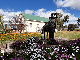
Pinjarra is a town in the Peel region of Western Australia along the South Western Highway, 82 kilometres (51 mi) from the state capital, Perth and 21 kilometres (13 mi) south-east of the coastal city of Mandurah. Its local government area is the Shire of Murray. At the 2016 census, Pinjarra had a population of 4910.

<span class="mw-page-title-main">Dwellingup, Western Australia</span> Town in Western Australia

Dwellingup is a town in Western Australia located in a timber and fruitgrowing area in the Darling Range east-south-east of Pinjarra. At the 2011 census, Dwellingup had a population of 383.

<span class="mw-page-title-main">Brunswick Junction, Western Australia</span> Town in Western Australia

Brunswick Junction is a town in the South West of Western Australia, situated along the South Western Highway between Harvey and Bunbury. It had a population of 772 people at the 2016 census, down from 797 at the 2006 census.

<span class="mw-page-title-main">Cookernup, Western Australia</span> Town in Western Australia

Cookernup is a town in the South West of Western Australia near the South Western Highway, between Waroona and Harvey.

<span class="mw-page-title-main">Harvey, Western Australia</span> Town in Western Australia

Harvey is a town located in the South West of Western Australia along the South Western Highway, 140 kilometres (87 mi) south of Perth, between Pinjarra and Bunbury. It has a population of 2,750. Harvey Town is known for its dairy industry and oranges.

<span class="mw-page-title-main">Boddington, Western Australia</span> Town in Western Australia

Boddington is a town and shire in the Peel region of Western Australia, located 120 kilometres (75 mi) south-east of Perth. The town sits on the road from Pinjarra to Williams on the Hotham River. The population of the town was 1,844 at the 2016 Census.

Roelands is a town in the South West region of Western Australia on the South Western Highway, between Brunswick Junction and Bunbury. At the 2011 census, Roelands had a population of 620.

Wokalup is a town located in the South West region of Western Australia along the South Western Highway, between Harvey and Brunswick Junction. At the 2006 census, Wokalup had a population of 449.

<span class="mw-page-title-main">Wandering, Western Australia</span> Town in the Wheatbelt region of Western Australia

Wandering is a town located in the Wheatbelt region of Western Australia, approximately 120 kilometres (75 mi) from the state capital, Perth, just off the Albany Highway. It is the main town in the Shire of Wandering. At the 2016 census, Wandering had a population of 294.

<span class="mw-page-title-main">Banksiadale, Western Australia</span> Town in Western Australia

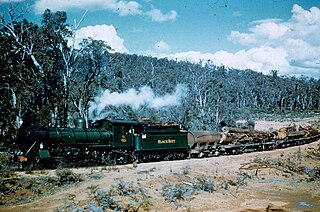
Banksiadale is a locality and former town in the Peel region of Western Australia north of Dwellingup. Its local government area is the Shire of Murray.

South Dandalup River is a river in the South West region of Western Australia.

<span class="mw-page-title-main">Shire of Murray</span> Local government area in Western Australia

The Shire of Murray is a local government area of Western Australia. It has an area of 1,710.1 square kilometres (660.3 sq mi) and is located in the Peel Region about 80 kilometres (50 mi) south of the Perth central business district.

<span class="mw-page-title-main">Victoria Park, Western Australia</span> Suburb of Perth, Western Australia

Victoria Park is an inner south eastern suburb of Perth, Western Australia. Its local government area is the Town of Victoria Park.

Piesseville is a small town in the Wheatbelt region of Western Australia, 211 kilometres (131 mi) south-east of Perth on the Great Southern Highway between Narrogin and Wagin. It is also on the Great Southern Railway. At the 2016 census, Piesseville had a population of 59.

Kudardup is a locality in the South West region of Western Australia. The locality is in the Shire of Augusta-Margaret River and on the Bussell Highway, 312 kilometres (194 mi) south of the state capital, Perth.

<span class="mw-page-title-main">Nambeelup, Western Australia</span> Town in Western Australia

Nambeelup is a small town and dormitory suburb of the city of Mandurah in the Peel Region of Western Australia.

References

  1. Australian Bureau of Statistics (28 June 2022). "North Dandalup (Suburb and Locality)". Australian Census 2021 QuickStats. Retrieved 28 June 2022.  OOjs UI icon edit-ltr-progressive.svg
  2. Australian Bureau of Statistics (31 October 2012). "North Dandalup (L) (Urban Centre/Locality)". 2011 Census QuickStats. Retrieved 31 October 2012. OOjs UI icon edit-ltr-progressive.svg
  3. "History of country town names – N". Western Australian Land Information Authority. Retrieved 17 January 2007.
  4. Australian Railway Historical Society Bulletin, May, 1965 pp 81-86
  5. Water Corporation of WA. "North Dandalup Dam" (PDF). Retrieved 20 February 2016.
  6. "Dandalup Springs" . Retrieved 11 May 2014.