Yalgorup National Park is a national park in Western Australia, 105 km south of Perth, and directly south of Mandurah.

Mandurah is a coastal city in the Australian state of Western Australia, situated approximately 72 kilometres (45 mi) south of the state capital, Perth. It is the state's second most populous city, with a population of 90,306.

Waroona is a town located in the Peel region of Western Australia along the South Western Highway, between Pinjarra and Harvey. The town is the seat of the Shire of Waroona. At the 2016 census, Waroona had a population of 2,934.

Yarloop is a town in the South West of Western Australia along the South Western Highway, between Waroona and Harvey. At the 2016 census, Yarloop had a population of 395. On 7 January 2016 a bushfire destroyed most of the town.

Pinjarra is a town in the Peel region of Western Australia along the South Western Highway, 82 kilometres (51 mi) from the state capital, Perth and 21 kilometres (13 mi) south-east of the coastal city of Mandurah. Its local government area is the Shire of Murray. At the 2016 census, Pinjarra had a population of 4910.

Harvey is a town located in the South West of Western Australia along the South Western Highway, 140 kilometres (87 mi) south of Perth, between Pinjarra and Bunbury. It has a population of 2,797. Harvey Town is known for its dairy industry and oranges.

South Western Highway is a highway in the South West region of Western Australia connecting Perth's southeast with Walpole. It is a part of the Highway 1 network for most of its length. It is about 406 kilometres (252 mi) long.
Bouvard is the second southernmost suburb of Mandurah, Western Australia, and is 97 kilometres (60 mi) south of the state capital, Perth. Its local government area is the City of Mandurah.

Collie-Preston is a Legislative Assembly electorate in the state of Western Australia. While the seat was known as Collie for just over a century of its existence as an electorate, the seat was known as South West Mining from 1901 to 1904, and Collie-Wellington from 2005 to 2008. It is named for the South West coal mining town of Collie. While historically a very safe seat for the Labor Party, redistributions in 1988 and 2007 due to increases in the quota for country seats which had historically been malapportioned resulted in the seat incorporating surrounding rural shires which were hostile to Labor and thereby becoming more marginal.
Binningup is a town on the coast of the South West region of Western Australia between Mandurah and Bunbury. At the 2016 census, Binningup had a population of 1,227.
Myalup is a town located on the coast in the South West region of Western Australia between Mandurah and Bunbury. At the 2006 census, Myalup had a population of 144.

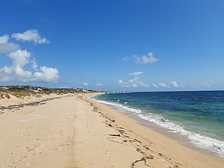
Preston Beach is a small town located in the Peel region of Western Australia just off the Forrest Highway, between Mandurah and Bunbury in the Yalgorup National Park.

The City of Mandurah is a local government area of Western Australia, covering both Mandurah proper and an additional area reaching down as far south as Lake Clifton. The city has a total area of approximately 174 square kilometres (67 sq mi).

Herron is a small suburb located in the Peel region of Western Australia just off the Old Coast Road, between Mandurah and Bunbury just beyond Mandurah's urban area. It is on a narrow strip between Lake Clifton and Yalgorup National Park to the west, and Harvey Estuary to the east.

The Shire of Waroona is a local government area in the Peel region of Western Australia between Mandurah and Harvey and about 110 kilometres south of Perth, the state capital. The Shire covers an area of about 835 km2 (322 sq mi) and its seat of government is the town of Waroona.

Forrest Highway is a 95-kilometre-long (59 mi) highway in Western Australia's Peel and South West regions, extending Perth's Kwinana Freeway from east of Mandurah down to Bunbury. Old Coast Road was the original Mandurah–Bunbury route, dating back to the 1840s. Part of that road, and the Australind Bypass around Australind and Eaton, were subsumed by Forrest Highway. The highway begins at Kwinana Freeway's southern terminus in Ravenswood, continues around the Peel Inlet to Lake Clifton, and heads south to finish at Bunbury's Eelup Roundabout. There are a number of at-grade intersections with minor roads in the shires of Murray, Waroona, and Harvey including Greenlands Road and Old Bunbury Road, both of which connect to South Western Highway near Pinjarra.

Clifton is a small uninhabited locality located in the Peel region of Western Australia, between Mandurah and Bunbury. Adjoining the nearby suburb of Herron. It lies on a narrow strip between Lake Clifton and Yalgorup National Park to the east, and the Indian Ocean to the west.
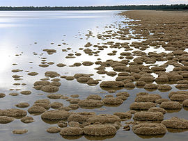
The Yalgorup Important Bird Area comprises a group of parallel, linear wetlands, with a collective area of 59 km2, on the Swan Coastal Plain of south-west Western Australia between the cities of Mandurah and Bunbury. It is an important site for waterbirds.

In Western Australia, Highway 1 is a 5,305-kilometre (3,296 mi) long route around the state, from the South Australian border near Eucla to the Northern Territory border near Kununurra. Highway 1 continues around the rest of Australia, joining all mainland state capitals, and connecting major centres in Tasmania. All roads within the Highway 1 system are allocated a road route numbered 1, M1, A1, or B1, depending on the state route numbering system. In Western Australia, most of the highway is designated as National Route 1; however, the sections in the north-east and south-east of the state that are concurrent with the National Highway routes linking Perth to Adelaide and Darwin are designated as National Highway 1.
The 2016 Waroona-Yarloop bushfire started in the east in the forests of the Darling Scarp before reaching the Swan Coastal Plain and continued westwards until it reached the Indian Ocean. It started as a lightning strike that caused two fires in the Lane Poole Reserve state forest near Dwellingup, Western Australia on 5 January 2016 and then burnt close to Waroona and then through the historical town of Yarloop, destroying it, before continuing southwards towards the outskirts of the town of Harvey and westwards to Preston Beach. Around 70,000 ha of land was burnt, two people died and at least 166 buildings were destroyed in Yarloop alone with only ninety buildings surviving. In total 181 buildings and structures were lost with the total cost of fighting the fire and the cost of the damage and the loss resulting estimated at $155 million.