
The City of Stirling is a local government area in the northern suburbs of the Western Australian capital city of Perth about 10 kilometres (6 mi) north of Perth's central business district. The City covers an area of 105.2 square kilometres (40.6 sq mi) and has a population of over 223,000, making it the largest local government area by population in Western Australia.
Crossman is a locality in the Shire of Boddington in the Peel Region of Western Australia, 125 kilometres (78 mi) south-southeast of the state capital, Perth, along Albany Highway, and 12 kilometres (7.5 mi) east of Boddington.

The Shire of Murray is a local government area of Western Australia. It has an area of 1,710.1 square kilometres (660.3 sq mi) and is located in the Peel Region about 80 kilometres (50 mi) south of the Perth CBD.

The Shire of Boddington is a local government area in the Peel region of Western Australia, about 120 kilometres (75 mi) south-east of the state capital, Perth. The Shire covers an area of 1,901 square kilometres (734 sq mi), and its seat of government is the town of Boddington.

The Shire of Collie is a local government area in the South West region of Western Australia, about 60 kilometres (37 mi) east of Bunbury and about 200 kilometres (124 mi) south of the state capital, Perth. The Shire covers an area of 1,711 square kilometres (661 sq mi), and its seat of government is the town of Collie.

The Shire of Woodanilling is a local government area in the Great Southern region of Western Australia, about 30 kilometres (19 mi) south of Wagin and about 260 kilometres (162 mi) south-southeast of the state capital, Perth. The Shire covers an area of 1,129 square kilometres (436 sq mi), and its seat of government is the town of Woodanilling.
Meelon is a small townsite in the Peel region of Western Australia, located between Pinjarra and Dwellingup within the Shire of Murray. At the 2011 census, Meelon had a population of 224.

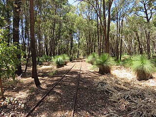
The Pinjarra to Narrogin railway was a 153 kilometre cross-country railway line built between the towns of Pinjarra and Narrogin in Western Australia.
West Pinjarra is a suburb of the town of Pinjarra in the Peel Region of Western Australia. Its local government area is the Shire of Murray.
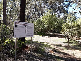
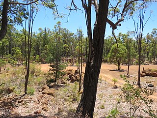
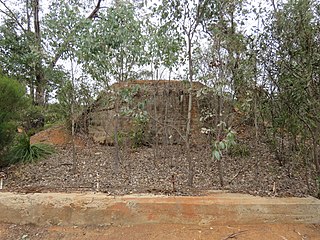
Marrinup is a rural locality and former town in the Peel region of Western Australia between Dwellingup and Pinjarra. Its local government area is the Shire of Murray. The town was destroyed in the 1961 bushfires and the townsite is now used as a campground. The ruins of the townsite are heritage listed. Little remains of the town other than an old bridge over Marrinup Creek and some wooden railway sleepers.
Etmilyn is a rural locality of the Shire of Murray in the Peel Region of Western Australia, located within the Dwellingup State Forest.
Holyoake is a rural locality of the Shire of Murray in the Peel Region of Western Australia, located within the Dwellingup State Forest.
Inglehope is a rural locality of the Shire of Murray in the Peel Region of Western Australia, located within the Dwellingup State Forest.
Bannister is a rural locality, predominately located within the Shire of Boddington in the Peel Region of Western Australia. A smaller part of the locality, located on the eastern side of the Albany Highway, is within the Shire of Wandering in the Wheatbelt region of the state. The locality is also home to the majority of the Boddington Gold Mine operations.
Lower Hotham is a rural locality located in the Shire of Boddington in the Peel Region of Western Australia. The Hotham River flows though the locality, joining the Williams River in the southern parts of Lower Hotham.
Upper Murray is a rural locality located in the Shire of Boddington in the Peel Region of Western Australia. The Murray River traverses the locality from its eastern to its western border.

Cardiff is a rural town in the Shire of Collie in the South West region of Western Australia.
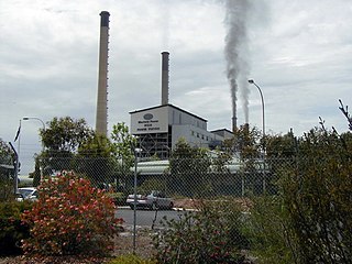
Muja is a rural town and locality of the Shire of Collie in the South West region of Western Australia. The western part of the locality is dominated by coal mining and the coal-fired Muja Power Station while the eastern part is rural and forested.
Mungalup is a rural town and locality of the Shire of Collie in the South West region of Western Australia.
Boyerine is a town and locality of the Shire of Woodanilling in the Great Southern region of Western Australia. The Great Southern Highway and the Great Southern Railway run through the locality from north to south. The Flagstaff Nature Reserve is located at the western border of Boyerine.

