
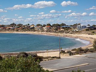
Scarborough is a coastal suburb of Perth, Western Australia, located approximately 14 km northwest of the city centre in the City of Stirling local government area. Located along the coast of the Indian Ocean, it was named after the English beach resort Scarborough, North Yorkshire.

Bull Creek is a suburb of Perth, Western Australia, located within the local government area of City of Melville. The suburb lies to the south of a creek of the same name, which flows into the Canning River.

Currambine is a northern suburb of Perth, the capital city of Western Australia, 29 km north of Perth's central business district. Its local government area is the City of Joondalup.
Bateman is a suburb of Perth, Western Australia, located within the City of Melville.

Clarkson is an outer northern suburb of Perth, Western Australia, located 34 kilometres north of Perth's central business district in the City of Wanneroo.

Secret Harbour is an outer southern suburb of the metropolitan area of Perth, the capital city of Western Australia, located within the City of Rockingham on the Indian Ocean coast at Warnbro Sound. Despite its name, Secret Harbour does not have a harbour. The name results from a failed marina development and was approved in 1984.
Coodanup is a south-eastern suburb of Mandurah, Western Australia. Its local government area is the City of Mandurah.

Dudley Park is a suburb of Mandurah, located immediately south of Mandurah's central area.

Erskine is a suburb of Mandurah. It is bound by the Old Coast Road to the west and the Peel Inlet to the east.
Falcon is a southern suburb of Mandurah, located southwest of Mandurah's central area and with frontage to both the Indian Ocean and the Peel-Harvey Estuary.
Greenfields is a suburb east of Mandurah, located east of Mandurah's central area. It includes several aged care residences and a large recreation oval and centre.

Halls Head is a coastal suburb (locality) of Mandurah, immediately west of Mandurah's central area. It is largely residential and contains several canal estates developed since the 1980s.

Lakelands is the northernmost suburb of the city of Mandurah, Western Australia.
Meadow Springs is a suburb of Mandurah, immediately northeast of Mandurah's central area. Alongside some of Mandurah's most recent land estates, it contains a large golf course, Catholic primary school, Anglican co-educational school, and a war veterans' estate. There are many parks and walking trails near the lake. The upcoming train station will provide convenient public transport, eliminating the need to drive into Mandurah to catch a train.

Wannanup is a residential suburb in Western Australia, located 12 kilometres (7 mi) southwest of Mandurah and 87 kilometres (54 mi) south-southwest of the state capital, Perth. It is surrounded on three sides by water – the Indian Ocean to the west, the Harvey Estuary to the east and the Dawesville Channel to the south – and is home to the Port Bouvard development. It is one of four suburbs which lie on an island created by the building of the Dawesville Channel.

Mandurah railway station is the terminus of the Mandurah railway line and a bus station on the Transperth network, serving the satellite city of Mandurah, Western Australia.

Madora Bay is a suburb of the City of Mandurah.

North Yunderup is a locality near Mandurah, Western Australia, located on the north bank of the Murray River within the Shire of Murray. Its postcode is 6208, and in the 2011 Census, it had a population of 849 with a median age of 46, nearly all of whom live in separate dwellings.

Furnissdale is a locality near Mandurah, Western Australia, to the south of Pinjarra Road and near the Serpentine River entrance into the Peel Inlet within the Shire of Murray. Its postcode is 6209. At the 2011 census, Furnissdale had a population of 1,027.
Mandurah is the central suburb of the city of Mandurah in Western Australia's Peel region. At the 2016 census, it had a population of 7,837.

