
The City of Stirling is a local government area in the northern suburbs of the Western Australian capital city of Perth about 10 kilometres (6 mi) north of Perth's central business district. The City covers an area of 105.2 square kilometres (40.6 sq mi) and has a population of over 223,000, making it the largest local government area by population in Western Australia.

The City of Cockburn is a local government area in the southern suburbs of the Western Australian capital city of Perth about 8 kilometres (5 mi) south of Fremantle and about 24 kilometres (15 mi) south of Perth's central business district. The City covers an area of 167.5 square kilometres (64.7 sq mi) and had a population of over 104,000 as at the 2016 Census.
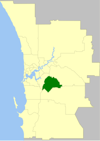
The City of Gosnells is a local government area in the southeastern suburbs of the Western Australian capital city of Perth, located northwest of Armadale and about 20 kilometres (12 mi) southeast of Perth's central business district. The City covers an area of 128 square kilometres (49.42 sq mi), a portion of which is state forest rising into the Darling Scarp to the east, and had a population of approximately 118,000 at the 2016 Census. The largest activity centre in the City is the Central Maddington shopping centre. District centres exist in the Gosnells town centre, Thornlie and Canning Vale.
The Shire of Serpentine-Jarrahdale is a local government area in the outer southeastern metropolitan area of Perth, the capital of Western Australia, and has an area of 905 square kilometres (349 sq mi) and a population of almost 27,000 as at the 2016 Census. The Shire's seat of government is the town of Mundijong.

The City of Swan is a local government area of Western Australia. It is in the eastern metropolitan region of Perth and includes the Swan Valley and 42 suburbs. It is centred approximately 20 km north-east of the Perth central business district. The City covers an area of 1,042 km² and had an estimated population of 155,653 in 2020.

The City of Wanneroo is a local government area with city status in the northern suburbs of Perth, Western Australia. It is centred approximately 25 kilometres (15.5 mi) north of Perth's central business district and forms part of the northern boundary of the Perth metropolitan area. Wangara encompasses the federal divisions of Cowan, Moore and Pearce.

The San Remo is a cooperative apartment building at 145 and 146 Central Park West, between 74th and 75th Streets, adjacent to Central Park on the Upper West Side of Manhattan in New York City. It was constructed from 1929 to 1930 and was designed by architect Emery Roth in the Renaissance Revival style. The San Remo is 27 stories tall, with twin towers rising from a 17-story base. The building is a contributing property to the Central Park West Historic District, listed on the National Register of Historic Places, and is a New York City designated landmark.

Milan–San Remo, also called "The Spring classic" or "La Classicissima", is an annual road cycling race between Milan and Sanremo, in Northwest Italy. With a distance of 298 km it is the longest professional one-day race in modern cycling. It is the first major classic race of the season, usually held on the third Saturday of March. The first edition was held in 1907.

Antonis Remos is a Greek singer.
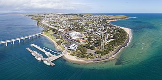
San Remo is a town in southern Victoria, Australia in the Gippsland region. Formed as a fishing village, its economy is now largely based on tourism. It is also notable as the town on the mainland end of the Phillip Island Bridge to Phillip Island. At the 2021 census, San Remo had a population of 1,700.
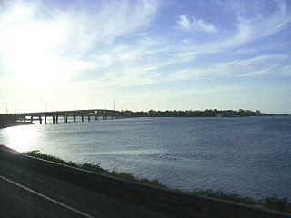
Newhaven is a town in southern Victoria, in the south Gippsland region. Located on Phillip Island, adjacent to the channel known as The Narrows, it is the town on the island side of the bridge linking Phillip Island to the mainland. At the 2016 census, Newhaven had a population of 449.

Silver Sands is an inner northern coastal suburb of Mandurah, Western Australia.
San Remo is a suburb of the Central Coast region of New South Wales, Australia. It is part of the Central Coast Council local government area and is home to Northlakes High School, which has over 1000 students, and the San Remo Neighbourhood Centre.

The City of Mandurah is a local government area of Western Australia, covering both Mandurah proper and an additional area reaching down as far south as Lake Clifton. The city has a total area of approximately 174 square kilometres (67 sq mi).
Utakarra is an eastern suburb of Geraldton, Western Australia. Its local government area is the City of Greater Geraldton. Prior to 1 July 2007, it was the seat of government of the Shire of Greenough.
Blue Haven is a suburb on the Central Coast of New South Wales, Australia, located on Pacific Highway at Wallarah Creek. Its local government area is Central Coast Council.

The 2011 Milan–San Remo was the 102nd running of the Milan–San Remo single-day cycling race. It was held on 19 March over a distance of 298 kilometres and was the fourth race of the 2011 UCI World Tour season.
The 1990 Milan–San Remo was the 81st edition of the Milan–San Remo cycle race and was held on 17 March 1990. The race started in Milan and finished in San Remo. The race was won by Gianni Bugno of the Chateau d'Ax team.
The 2022 Milan–San Remo was a road cycling one-day race that took place on 19 March 2022 in northwestern Italy. It was the 113th edition of the Milan–San Remo cycling classic. Originally the eighth event on the 2022 UCI World Tour calendar, it became the sixth event after the cancellation of the Tour Down Under and the Cadel Evans Great Ocean Road Race.

