Falcon, Western Australia

Last updated

Falcon
Mandurah,  Western Australia
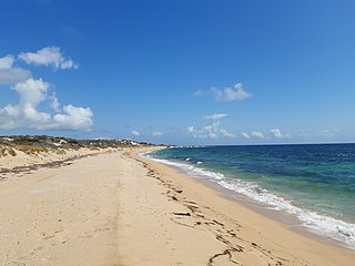
Falcon-bay-western-australia.jpg
Falcon Bay
Falcon, Western Australia
Coordinates 32°34′44″S115°39′32″E / 32.579°S 115.659°E / -32.579; 115.659 Coordinates: 32°34′44″S115°39′32″E / 32.579°S 115.659°E / -32.579; 115.659
Population5,531 (SAL 2021) [1]
Postcode(s) 6210
Area12.6 km2 (4.9 sq mi)
LGA(s) City of Mandurah
State electorate(s) Dawesville
Federal division(s) Canning
Suburbs around Falcon:
Halls Head Erskine
Falcon Erskine
Wannanup

Falcon is a southern suburb of Mandurah, located southwest of Mandurah's central area and with frontage to the Indian Ocean. The suburb was named after Falcon Bay. Falcon was approved as a suburb name on 13 November 1967 and gazetted on 8 March 1968. Many of the streets in the adjoining estate were named after yachts; "Falcon" itself was the name of a yacht, the crew of which won a silver medal in the 12m² Sharpie yacht races at the 1956 Melbourne Olympics.

Contents

Geography

Falcon is one of four Mandurah suburbs that lie on an island bound by the Mandurah Estuary to the north, the Peel-Harvey Estuary to the east, the Dawesville Channel to the south and the Indian Ocean to the west. It is also bisected by Old Coast Road, which connects Falcon to nearby Mandurah and Bunbury.

Falcon was formerly known as Miami, which is still used in the names of various buildings, including the multi-award winning Miami Bakehouse and Miami Plaza, which is home to a Woolworths supermarket and a large variety of fast food outlets.

Public transport

Falcon, like neighbouring suburbs Wannanup and Dawesville, is serviced by Transperth routes 592 and 594. 592 runs six days a week through Falcon via Galatea and Yeedong Roads while 594 goes straight through the suburb via Old Coast Road, but runs 7 days a week. Services generally run every twenty minutes during peak hour with 592 and 594 alternating every ten minutes in terms of departing Mandurah Station, with some school specials deviating from this normal pattern.

Stories of Local People & Places

• In 1950-53 Fernly Maidment bought property in Falcon. Fernly was one of a number of fishermen who went looking for the Presentation Sisters who drowned, along with a priest, heading back to Mandurah. He worked as an agent for Bassett Scarfe & Watson. Grandfather of current resident. He moved to Furnissdale in 1969.

• There is a capsized boat at the bottom of South East Dawesville Channel Estuary "Josephine" – it belonged to a Falcon resident's father who lived on the boat for many years. He also crewed on most boats at Royal Perth Yacht Club whose names are now Falcon street-names and he can remember them all.

• Local street names repeat some of the champion ocean and Swan River racing yachts, for example Panamuna Drive and Verona Crescent.

• Late 1950s/1960s Geary's beach surf break was named after Ray and Helen Geary's beach shack in Sandra Street. The boys would head over the back beach with their "planks" and drink beer at the shack afterwards.

• The first school with the City of Mandurah local government area boundary was built at Pleasant Grove in 1906, pre-dating the Central Mandurah public school on Hackett Street by 30 years. It closed in 1916.

• The first brick and tile houses in Falcon were built on Mercedes Avenue.

• In the late-90s, the band Turnstyle made several visits to Falcon to write music in solitude at the holiday home of guitarist Adem K on Philante Street. Most of the album Turnstyle Country was written here including the top 20 single "Spray Water on the Stereo" which directly references the home in its lyrics.

Related Research Articles

<span class="mw-page-title-main">Mandurah</span> City in Western Australia

Mandurah is a coastal city in the Australian state of Western Australia, situated approximately 72 kilometres (45 mi) south of the state capital, Perth. It is the state's second most populous city, with a population of 107,641 as of the 2021 census.

<span class="mw-page-title-main">Mornington, Victoria</span> Suburb of Melbourne, Victoria, Australia

Mornington is a suburb on the Mornington Peninsula in Melbourne, Victoria, Australia, 46 km (29 mi) south-east of Melbourne's Central Business District, located within the Shire of Mornington Peninsula local government area. Mornington recorded a population of 25,759 at the 2021 census.

<span class="mw-page-title-main">Black Rock, Victoria</span> Suburb of Melbourne, Victoria, Australia

Black Rock is a suburb in Melbourne, Victoria, Australia, 18 km south-east of Melbourne's Central Business District, located within the City of Bayside local government area. Black Rock recorded a population of 6,389 at the 2021 census.

<span class="mw-page-title-main">Watermans Bay, Western Australia</span> Suburb of Perth, Western Australia

Watermans Bay is a northern coastal suburb of Perth, the capital city of Western Australia. Its local government area is the City of Stirling.

<span class="mw-page-title-main">Quinns Rocks, Western Australia</span> Suburb of Perth, Western Australia

Quinns Rocks is an outer coastal suburb of Perth, Western Australia, located 38 kilometres (24 mi) north of Perth's central business district. It is part of the City of Wanneroo local government area. The suburb was formerly established in 1962 as a rural townsite, focused around Quinns Beach, the area's main amenity.

<span class="mw-page-title-main">Marmion, Western Australia</span> Suburb of Perth, Western Australia

Marmion is a northern coastal suburb of Perth, the capital city of Western Australia. Its local government area is the City of Joondalup.

<span class="mw-page-title-main">Safety Bay, Western Australia</span> Suburb of Perth, Western Australia

Safety Bay is an outer southern suburb of Perth, the capital city of Western Australia, located on the coast within the City of Rockingham.

<span class="mw-page-title-main">Bouvard, Western Australia</span> Suburb of Mandurah, Western Australia

Bouvard is the second southernmost suburb of Mandurah, Western Australia, and is 97 kilometres (60 mi) south of the state capital, Perth. Its local government area is the City of Mandurah.
<span class="mw-page-title-main">Dawesville, Western Australia</span> Suburb of Mandurah, Western Australia

Dawesville is a suburb of Mandurah, located adjacent to the Peel-Harvey Estuarine System south of Perth in Western Australia. The Dawesville Cut is to the north of the suburb.

<span class="mw-page-title-main">Erskine, Western Australia</span> Suburb of Mandurah, Western Australia

Erskine is a suburb of Mandurah. It is bound by the Old Coast Road to the west and the Peel Inlet to the east. It is home to a minor shopping centre, including a Coles supermarket.
<span class="mw-page-title-main">Halls Head, Western Australia</span> Suburb of Mandurah, Western Australia

Halls Head is a coastal suburb (locality) of Mandurah, immediately west of Mandurah's central area. It is largely residential and contains several canal estates developed since the 1980s.

<span class="mw-page-title-main">Wannanup</span> Suburb of Mandurah, Western Australia

Wannanup is a residential suburb in Western Australia, located 12 kilometres (7 mi) southwest of Mandurah and 87 kilometres (54 mi) south-southwest of the state capital, Perth. It is surrounded on three sides by water – the Indian Ocean to the west, the Harvey Estuary to the east and the Dawesville Channel to the south – and is home to the Port Bouvard development. It is one of four suburbs which lie on an island created by the building of the Dawesville Channel.

<span class="mw-page-title-main">Electoral district of Dawesville</span> State electoral district of Western Australia

Dawesville is a Legislative Assembly electorate in the state of Western Australia. Dawesville is named for the southwestern Mandurah suburb of Dawesville which falls within its borders.

<span class="mw-page-title-main">Mandurah railway station</span> Railway station in Perth, Western Australia

Mandurah Station is the terminus of the Mandurah railway line and a bus station on the Transperth network, serving the satellite city of Mandurah, Western Australia.

<span class="mw-page-title-main">City of Mandurah</span> Local government area in Western Australia

The City of Mandurah is a local government area of Western Australia, covering both Mandurah proper and an additional area reaching down as far south as Lake Clifton. The city has a total area of approximately 174 square kilometres (67 sq mi).

<span class="mw-page-title-main">Herron, Western Australia</span> Town in Western Australia

Herron is a small suburb located in the Peel region of Western Australia just off the Old Coast Road, between Mandurah and Bunbury just beyond Mandurah's urban area. It is on a narrow strip between Lake Clifton and Yalgorup National Park to the west, and Harvey Estuary to the east.

<span class="mw-page-title-main">Peel-Harvey Estuarine System</span> Estuarine system south of Mandurah, Western Australia

The Peel-Harvey Estuarine System is a natural estuarine system that lies roughly parallel to the coast of Western Australia and south of the town of Mandurah.

<span class="mw-page-title-main">Dawesville Channel</span> Artificial channel near Mandurah, Western Australia

Dawesville Channel is an artificial channel between the Peel-Harvey Estuary and the Indian Ocean at Dawesville, about 80 km (50 mi) south of Perth in Western Australia. It is south of the regional city of Mandurah and north of Yalgorup National Park.

<span class="mw-page-title-main">Forrest Highway</span> Highway in Western Australia

Forrest Highway is a 95-kilometre-long (59 mi) highway in Western Australia's Peel and South West regions, extending Perth's Kwinana Freeway from east of Mandurah down to Bunbury. Old Coast Road was the original Mandurah–Bunbury route, dating back to the 1840s. Part of that road, and the Australind Bypass around Australind and Eaton, were subsumed by Forrest Highway. The highway begins at Kwinana Freeway's southern terminus in Ravenswood, continues around the Peel Inlet to Lake Clifton, and heads south to finish at Bunbury's Eelup Roundabout. There are a number of at-grade intersections with minor roads in the shires of Murray, Waroona, and Harvey including Greenlands Road and Old Bunbury Road, both of which connect to South Western Highway near Pinjarra.

<span class="mw-page-title-main">Rockingham, Western Australia</span> City in Western Australia

Rockingham is a suburb of Perth, Western Australia, located 47 km south-south-west of the city centre. It acts as the primary centre for the City of Rockingham. It has a beachside location at Mangles Bay, the southern extremity of Cockburn Sound. To its north stretches the maritime and resource-industry installations of Kwinana and Henderson. Offshore to the north-west is Australia's largest naval fleet and submarine base, Garden Island, connected to the mainland by an all-weather causeway. To the west and south lies the Shoalwater Islands Marine Park.

References

  1. Australian Bureau of Statistics (28 June 2022). "Falcon (Suburb and Locality)". Australian Census 2021 QuickStats. Retrieved 28 June 2022.  OOjs UI icon edit-ltr-progressive.svg