Point Grey, Western Australia

Last updated

Point Grey
Western Australia
Point Grey, Western Australia
Coordinates 32°41′S115°41′E / 32.68°S 115.69°E / -32.68; 115.69
Population0 (SAL 2016) [1]
Postcode(s) 6208
Area26.9 km2 (10.4 sq mi)
Location
LGA(s) Shire of Murray
State electorate(s) Murray-Wellington
Federal division(s) Canning
Suburbs around Point Grey:
Point Grey Nirimba
Birchmont Nirimba

Point Grey is a rural locality of the Shire of Murray in the Peel Region of Western Australia, located on the eastern shore of the Harvey Estuary and the southern shore of the Peel Inlet. [2] [3]

The Shire of Murray and the locality of Point Grey are located on the traditional land of the Pindjarup people of the Noongar nation. [4] The Pindjarup language is now considered extinct but the Noongar people remain present in the region. [5]

The locality is home to the heritage-listed Culjum House, which was constructed in 1850 by early settler Lewis Birch, after a previous attempt to built a house nearby failed because of an unsuitable location. The house is named after the Aboriginal name of the area, Culjum. [6]

Point Grey was the site of a proposed marina by Hong Kong-based developer Tian An Australia since 2012. [7] [8]

The proposal was voted against by the council of the Shire of Murray in May 2020. The construction of a 300-berth marina, the dredging of a 2.5-kilometre channel across the Peel-Harvey Estuary, and the proposed residential and tourism infrastructure were deemed environmental and financially unsound. The developer's chief operating officer, Hai-Young Lu, said the company would continue to pursue the project. [9] The project was eventually stopped in December 2021 when the Western Australian state government approved an amendment to the local planning scheme that disallowed the construction of the marina. [10] Apart from the marina, Tian An Australia also proposed the construction of 3,000 homes at Point Grey. [11]

Related Research Articles

<span class="mw-page-title-main">Peel (Western Australia)</span> Region of Western Australia

The Peel region is one of the nine regions of Western Australia. It is located on the west coast of Western Australia, about 75 km (47 mi) south of the state capital, Perth. It consists of the City of Mandurah, and the Shires of Boddington, Murray, Serpentine-Jarrahdale and Waroona.

<span class="mw-page-title-main">Pinjarra, Western Australia</span> Town in Western Australia

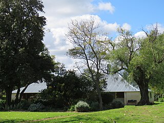
Pinjarra is a town in the Peel region of Western Australia along the South Western Highway, 82 kilometres (51 mi) from the state capital, Perth and 21 kilometres (13 mi) south-east of the coastal city of Mandurah. Its local government area is the Shire of Murray. At the 2016 census, Pinjarra had a population of 4910.

<span class="mw-page-title-main">City of Mandurah</span> Local government area in Western Australia

The City of Mandurah is a local government area of Western Australia, covering both Mandurah proper and an additional area reaching down as far south as Lake Clifton. The city has a total area of approximately 174 square kilometres (67 sq mi).

<span class="mw-page-title-main">Shire of Murray</span> Local government area in Western Australia

The Shire of Murray is a local government area of Western Australia. It has an area of 1,710.1 square kilometres (660.3 sq mi) and is located in the Peel Region about 80 kilometres (50 mi) south of the Perth central business district.

<span class="mw-page-title-main">Shire of Waroona</span> Local government area in Western Australia

The Shire of Waroona is a local government area in the Peel region of Western Australia between Mandurah and Harvey and about 110 kilometres (68 mi) south of Perth, the state capital. The Shire covers an area of about 835 km² (322 mi²) and its seat of government is the town of Waroona.

<span class="mw-page-title-main">Peel-Harvey Estuarine System</span> Estuarine system south of Mandurah, Western Australia

The Peel-Harvey Estuarine System is a natural estuarine system that lies roughly parallel to the coast of Western Australia and south of the town of Mandurah.

<span class="mw-page-title-main">City of Rockingham</span> Local government area in Western Australia

The City of Rockingham is a council and local government area, comprising the south coastal suburbs of the Western Australian capital city of Perth.

<span class="mw-page-title-main">Murray River (Western Australia)</span> River in Peel region of Western Australia

The Murray River is a river in the southwest of Western Australia. It played a significant part in the expansion of settlement in the area south of Perth after the arrival of British settlers at the Swan River Colony in 1829.

<span class="mw-page-title-main">Roy Hill railway</span> Private railway in Pilbara region of Western Australia

The Roy Hill railway, officially the Roy Hill Infrastructure railway, owned and operated by Hancock Prospecting, is a private rail network in the Pilbara region of Western Australia built to carry iron ore.

<span class="mw-page-title-main">Birchmont, Western Australia</span> Locality in the Shire of Murray

Birchmont is a rural locality of the Shire of Murray in the Peel Region of Western Australia, located on the eastern shore of the Harvey Estuary.

<span class="mw-page-title-main">Blythewood, Western Australia</span> Locality in the Shire of Murray

Blythewood is a rural locality of the Shire of Murray in the Peel Region of Western Australia.

<span class="mw-page-title-main">Etmilyn, Western Australia</span> Locality in the Shire of Murray

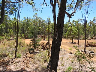
Etmilyn is a rural locality of the Shire of Murray in the Peel Region of Western Australia, located within the Dwellingup State Forest.

Holyoake is a rural locality of the Shire of Murray in the Peel Region of Western Australia, located within the Dwellingup State Forest.

<span class="mw-page-title-main">Inglehope, Western Australia</span> Locality in the Shire of Murray

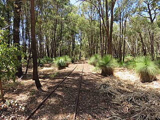
Inglehope is a rural locality of the Shire of Murray in the Peel Region of Western Australia, located within the Dwellingup State Forest.

Myara is a rural locality of the Shire of Murray in the Peel Region of Western Australia, located on the northern shore of the North Dandalup Dam.

Solus is a rural locality of the Shire of Murray in the Peel Region of Western Australia.

Teesdale is a rural locality of the Shire of Murray in the Peel Region of Western Australia.

West Coolup is a rural locality of the Shire of Murray in the Peel Region of Western Australia, located on the eastern shore of the Harvey Estuary.

<span class="mw-page-title-main">Whittaker, Western Australia</span> Locality in the Shire of Murray

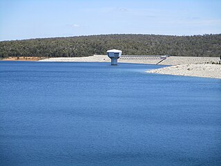
Whittaker is a rural locality of the Shire of Murray in the Peel Region of Western Australia. North Dandalup Dam and its reservoir are located within the locality in its north-western corner.

<span class="mw-page-title-main">Upper Murray, Western Australia</span> Locality in the Shire of Boddington, Western Australia

Upper Murray is a rural locality located in the Shire of Boddington in the Peel Region of Western Australia. The Murray River traverses the locality from its eastern to its western border.

References

  1. Australian Bureau of Statistics (27 June 2017). "Point Grey (Suburb and Locality)". Australian Census 2016.  OOjs UI icon edit-ltr-progressive.svg
  2. "SLIP Map". maps.slip.wa.gov.au. Landgate . Retrieved 10 August 2023.
  3. "NationalMap". nationalmap.gov.au. Geoscience Australia . Retrieved 10 August 2023.
  4. "Pindjarup". www.boodjar.sis.uwa.edu.au. University of Western Australia . Retrieved 10 August 2023.
  5. "Pindjarup (WA)". www.samuseum.sa.gov.au. South Australian Museum . Retrieved 10 August 2023.
  6. "Culjum House". inherit.stateheritage.wa.gov.au. Heritage Council of Western Australia. Retrieved 10 August 2023.
  7. Western Australia. Environmental Protection Authority (2011), Point Grey Marina : Point Grey Development Company Pty Ltd, Office of the Environmental Protection Authority, retrieved 10 August 2023
  8. Western Australia. Environmental Protection Authority; Point Grey Development Company (2017), Point Grey Marina proposal - inquiry under section 46 of the Environmental Protection Act 1986 to amend Ministerial Statement 906 : Point Grey Development Company Pty Ltd, Office of the Environmental Protection Authority, retrieved 10 August 2023
  9. Meerton, Kaylee (13 May 2020). "Tian An Australia 'remains committed' to Point Grey Marina project". Mandurah Mail. Mandurah . Retrieved 10 August 2023.
  10. Welhan, Monique (3 December 2021). "Point Grey marina plans officially quashed after years of opposition". 97.3 Coast FM. Mandurah . Retrieved 10 August 2023.
  11. Gubana, Benjamin (1 October 2019). "Point Grey marina plan sparks environmental fears in Mandurah as Tian An fights to start work". ABC News . Retrieved 10 August 2023.