North Central Victoria is a rural region in the Australian state of Victoria. The region lies to the south of the Victorian/New South Wales border as defined by the Murray River, to the southwest of the Hume region, to the west of the Great Dividing Range contained within the Central Highlands and Victorian Alps, to the north of Greater Melbourne, to the northeast of the Wimmera, and to the east of the Mallee region.

Nyah West is a town in Victoria, Australia near the Murray River, the border with New South Wales. It is near the Murray Valley Highway, 371 kilometres (231 mi) north-west of Melbourne and 27 kilometres (17 mi) north-west of Swan Hill.

The Division of Parkes is an Australian electoral division in the state of New South Wales. The largest electorate in the state, it is located in the far north west of the state, adjoining the border with Queensland in the north and with South Australia in the west. The division is named after Sir Henry Parkes, seventh Premier of New South Wales and sometimes known as the 'Father of Federation'. The division was proclaimed at the redistribution of 11 October 1984, and was first contested at the 1984 federal election.
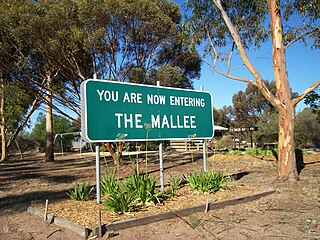
The Mallee is an ill-defined district, sometimes incorrectly referred to as an economic region, of the Australian state of Victoria. The district is located entirely within the Loddon Mallee region; and covers the most northwesterly district in the state bounded by the South Australian and New South Wales borders, inclusive of the Murray River.

Pinjarra is a town in the Peel region of Western Australia along the South Western Highway, 86 kilometres (53 mi) from the state capital, Perth and 21 kilometres (13 mi) south-east of the coastal city of Mandurah. Its local government area is the Shire of Murray. At the 2011 census, Pinjarra had a population of 4,255.

North Dandalup is a small town in the Peel region of Western Australia along the South Western Highway between Serpentine and Pinjarra. Its local government area is the Shire of Murray. At the 2011 census, North Dandalup had a population of 346.
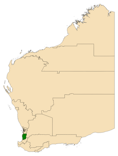
Murray-Wellington is an electoral district of the Legislative Assembly in the Australian state of Western Australia. The seat's current member is Labor MLA Robyn Clarke.

Howlong is a town 28 kilometres (17 mi) west of Albury, and is situated on the Murray River which separates the Australian states of New South Wales and Victoria. The town is located on the Riverina Highway. There is a bridge across the Murray into Victoria. Howlong is in the Federation Council local government area. At the 2011 census, Howlong had a population of 2,551.

The City of Albury is a local government area in the Riverina region of New South Wales, Australia. The area covers 305.9 square kilometres (118.1 sq mi) to the north of the Murray River. The area extends around 10 to 12 kilometres east and west along the river from the centre of Albury and up to 20 kilometres (12 mi) north.

Lower Mitcham is an inner southern suburb of Adelaide, South Australia in the local government area of Mitcham. To the north, it is bounded by Grange Road, to the east by Belair Road, to the south by Murray Street. To the west, the suburb is bordered by a line running from Murray Street along View Street and continuing north to Grange Road.
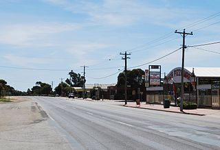
Nyah is a town in northern Victoria, Australia. The town is located on the Murray Valley Highway, in the Rural City of Swan Hill local government area, 365 kilometres (227 mi) north west of the state capital, Melbourne. At the 2011 census, Nyah had a population of 483.
South Yunderup is a township near Mandurah, Western Australia, located on the south bank of the Murray River within the Shire of Murray. Its postcode is 6208, and in the 2011 Census, it had a population of 2,235 with a median age of 50. South Yunderup is also the second-largest township in the Shire of Murray after the main town, Pinjarra.
Yunderup may refer to several places:
Furnissdale is a locality near Mandurah, Western Australia, to the south of Pinjarra Road and near the Serpentine River entrance into the Peel Inlet within the Shire of Murray. Its postcode is 6209. At the 2011 census, Furnissdale had a population of 1,027.

Keyneton is a locality in South Australia. The town is in the Mid Murray Council local government area, 82 kilometres (51 mi) north-east of the state capital, Adelaide. At the 2011 census, Keyneton and the surrounding area had a population of 534.
Nirimba is a rural locality in the Shire of Murray in the Peel Region of Western Australia, located directly south of the Austin Cove development in South Yunderup.

The Hume is an economic rural region located in the north-eastern part of Victoria, Australia. Comprising an area in excess of 40,000 square kilometres (15,000 sq mi) with a population that ranges from 263,000 to 300,000, the Hume region includes the local government areas of Alpine Shire, Rural City of Benalla, City of Wodonga, City of Greater Shepparton, Shire of Indigo, Shire of Mansfield, Shire of Strathbogie, Shire of Towong and the Rural City of Wangaratta, and also includes five unincorporated areas encompassing the alpine ski resorts in the region.
Caloote is a town and its surrounding locality on the right bank of the Murray River in the Mid Murray Council in South Australia. The southern extent of the locality is in the Rural City of Murray Bridge.


