
Mandurah is a coastal city in the Australian state of Western Australia, situated approximately 72 kilometres (45 mi) south of the state capital, Perth. It is the state's second most populous city, with a population of 107,641 as of the 2021 census.
The Shire of Serpentine-Jarrahdale is a local government area in the outer southeastern metropolitan area of Perth, the capital of Western Australia, and has an area of 905 square kilometres (349 sq mi) and a population of almost 27,000 as at the 2016 Census. The Shire's seat of government is the town of Mundijong.

Bull Creek is a suburb of Perth, Western Australia, located within the local government area of City of Melville. The suburb lies to the south of a creek of the same name, which flows into the Canning River.

The Peel region is one of the nine regions of Western Australia. It is located on the west coast of Western Australia, about 75 km (47 mi) south of the state capital, Perth. It consists of the City of Mandurah, and the Shires of Boddington, Murray, Serpentine-Jarrahdale and Waroona.

Ferndale is a southeastern suburb of Perth, Western Australia. Its local government area is the City of Canning. It is approximately 15 kilometres (9 mi) from Perth's central business district.

Como is a suburb of Perth, Western Australia. Its local government area is the City of South Perth. The suburb has a population of 12,423. Canning Highway divides the suburb.

Serpentine is a town located 55 kilometres (34 mi) south-southeast of Perth, the capital of Western Australia, and 7 km south of Mundijong.
Bateman is a suburb of Perth, Western Australia, located within the City of Melville.
Bouvard is the second southernmost suburb of Mandurah, Western Australia, and is 97 kilometres (60 mi) south of the state capital, Perth. Its local government area is the City of Mandurah.
Falcon is a southern suburb of Mandurah, located southwest of Mandurah's central area and with frontage to the Indian Ocean. The suburb was named after Falcon Bay. Falcon was approved as a suburb name on 13 November 1967 and gazetted on 8 March 1968. Many of the streets in the adjoining estate were named after yachts; "Falcon" itself was the name of a yacht, the crew of which won a silver medal in the 12m² Sharpie yacht races at the 1956 Melbourne Olympics.

Wannanup is a residential suburb in Western Australia, located 12 kilometres (7 mi) southwest of Mandurah and 87 kilometres (54 mi) south-southwest of the state capital, Perth. It is surrounded on three sides by water – the Indian Ocean to the west, the Harvey Estuary to the east and the Dawesville Channel to the south – and is home to the Port Bouvard development. It is one of four suburbs which lie on an island created by the building of the Dawesville Channel.
Stake Hill is a northeastern rural residential suburb of Mandurah, Western Australia. Its local government area is the Shire of Murray. At the 2011 census, Stake Hill had a population of 494.

The Serpentine River is a river in the South West region of Western Australia. It is known as Waangaamaap Bilya to the Indigenous Bindjareb people, who met, lived and fished there before British settlement.

Preston Beach is a small town located in the Peel region of Western Australia just off the Forrest Highway, between Mandurah and Bunbury in the Yalgorup National Park.

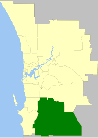
The City of Mandurah is a local government area of Western Australia, covering both Mandurah proper and an additional area reaching down as far south as Lake Clifton. The city has a total area of approximately 174 square kilometres (67 sq mi).

The City of Rockingham is a council and local government area, comprising the south coastal suburbs of the Western Australian capital city of Perth.

Barragup is a locality near Mandurah, Western Australia, located north of Pinjarra Road and east of the Serpentine River within the Shire of Murray. Its postcode is 6209. At the 2016 census, Barragup had a population of 806.

Furnissdale is a locality near Mandurah, Western Australia, to the south of Pinjarra Road and near the Serpentine River entrance into the Peel Inlet within the Shire of Murray. Its postcode is 6209. At the 2011 census, Furnissdale had a population of 1,027.

Nambeelup is a small town and dormitory suburb of the city of Mandurah in the Peel Region of Western Australia.

Mardella is an outer suburb of Perth, Western Australia, lying approximately 41 kilometres (25 mi) south-southeast of the central business district. It is located within the Shire of Serpentine-Jarrahdale, and at the 2011 census had a population of 303 people. Although falling within the Perth metropolitan area, Mardella is mostly rural in nature, with a significant proportion of the population engaged in farming.

