Serpentine River (Western Australia)

Last updated

Serpentine River
Serpentine River above falls.jpg
Location
CountryAustralia
Physical characteristics
Source 
  locationBowerling Hill
  elevation313 metres (1,027  ft) [1]
Mouth  
  location
Peel Inlet
  elevation
sea level
Length111 kilometres (69  mi)

The Serpentine River is a river in the South West region of Western Australia. It is known as Waangaamaap Bilya to the Indigenous Bindjareb people, who met, lived and fished there before British settlement. [2]

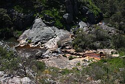
The river rises in the Darling Scarp below Bowerling Hill and flows westward crossing Albany Highway north of North Bannister. The river continues northwest through the Youarling State Forest then the Serpentine National Park. The river flows through Serpentine Dam then flows over Serpentine Falls just south of Jarrahdale as it comes off the Scarp and onto the Swan Coastal Plain. The river continues west and crosses the South Western Highway then flows past the town of Serpentine. The river then veers south and continues until it discharges into the Peel Inlet near Mandurah.

The upper reaches of the river flow into Serpentine Dam, which provides drinking water to the Perth metropolitan area.

The only tributary to the Serpentine River is Big Brook. Additionally, the Peel Main Drain discharges into the Serpentine River at Karnup. [3] The river also flows through Kerulup Pool, Lake Amarillo and Goegrup Lake.

The river is known to have toxic algal blooms, last occurring in 2007. Algal blooms usually occur after hot weather and in the upper reaches of the river. [4]

Related Research Articles

<span class="mw-page-title-main">Swan River (Western Australia)</span> River in Perth, Western Australia

The Swan River is a major river in the southwest of Western Australia. The river runs through the metropolitan area of Perth, Western Australia's capital and largest city.

<span class="mw-page-title-main">Serpentine National Park</span> Protected area in Western Australia

The Serpentine National Park is a national park located on the Darling Scarp, approximately 55 kilometres (34 mi) southeast of Perth in Western Australia. The depth of the falls has been undetermined, and is shrouded with conspiracy and enigmatism.

<span class="mw-page-title-main">Darling Scarp</span> Scarp east of Perth, Western Australia

The Darling Scarp, also referred to as the Darling Range or Darling Ranges, is a low escarpment running north–south to the east of the Swan Coastal Plain and Perth, Western Australia. The escarpment extends generally north of Bindoon, to the south of Pemberton. The adjacent Darling Plateau goes easterly to include Mount Bakewell near York and Mount Saddleback near Boddington. It was named after the Governor of New South Wales, Lieutenant-General Ralph Darling.

<span class="mw-page-title-main">Mandurah</span> City in Western Australia

Mandurah is a coastal city in the Australian state of Western Australia, situated approximately 72 kilometres (45 mi) south of the state capital, Perth. It is the state's second most populous city, with a population of 90,306.

The Kwinana Freeway is a 72-kilometre (45 mi) freeway in and beyond the southern suburbs of Perth, Western Australia, linking central Perth with Mandurah to the south. It is the central section of State Route 2, which continues north as Mitchell Freeway to Clarkson, and south as Forrest Highway towards Bunbury. A 4-kilometre (2.5 mi) section between Canning and Leach highways is also part of National Route 1. Along its route are interchanges with several major roads, including Roe Highway and Mandjoogoordap Drive. The northern terminus of the Kwinana Freeway is at the Narrows Bridge, which crosses the Swan River, and the southern terminus is at Pinjarra Road, east of Mandurah.

<span class="mw-page-title-main">Division of Canning</span> Australian federal electoral division

The Division of Canning is an Australian Electoral Division in Western Australia.

<span class="mw-page-title-main">Canning River</span> River in Perth, Western Australia

Stake Hill is a northeastern rural residential suburb of Mandurah, Western Australia. Its local government area is the Shire of Murray. On 10 August 2021 Stake Hill had a population of 469.

<span class="mw-page-title-main">Serpentine Dam (Western Australia)</span> Dam in Western Australia

The Serpentine Dam is a major water supply dam for Perth, Western Australia. The dam is used to store water that is released at a controlled rate to regulate the level in the Serpentine Pipehead Dam reservoir, which in turn feeds water to the metropolitan trunk main network depending on demand. Construction of the dam was completed in 1961.

<span class="mw-page-title-main">South Dandalup River</span> River in Western Australia

South Dandalup River is a river in the South West region of Western Australia.

<span class="mw-page-title-main">City of Mandurah</span> Local government area in Western Australia

The City of Mandurah is a local government area of Western Australia, covering both Mandurah proper and an additional area reaching down as far south as Lake Clifton. The city has a total area of approximately 174 square kilometres (67 sq mi).

<span class="mw-page-title-main">Peel-Harvey Estuarine System</span> Estuarine system south of Mandurah, Western Australia

The Peel-Harvey Estuarine System is a natural estuarine system that lies roughly parallel to the coast of Western Australia and south of the town of Mandurah.

<span class="mw-page-title-main">Murray River (Western Australia)</span> River in Peel region of Western Australia

The Murray River is a river in the southwest of Western Australia. It played a significant part in the expansion of settlement in the area south of Perth after the arrival of British settlers at the Swan River Colony in 1829.

<span class="mw-page-title-main">Canning Dam</span> Dam in Roleystone, Western Australia

The Canning Dam and reservoir are a major source of fresh water for the city of Perth, Western Australia. The dam is situated on the Darling Scarp and is an impoundment of the Canning River. It is noted for its innovative structural and hydraulic design that was considered to be at the forefront of concrete gravity dam design at the time of construction in from 1933 to its completion 1940.

<span class="mw-page-title-main">Dawesville Channel</span> Artificial channel near Mandurah, Western Australia

The Serpentine Dam is a rockfill embankment dam with a concrete face and a controlled spillway across the Serpentine River, located in the South West region of Tasmania, Australia.

The Edgar Dam is an earthfill embankment saddle dam without a spillway, located offstream in the South West region of Tasmania, Australia.

<span class="mw-page-title-main">Forrest Highway</span> Highway in Western Australia

Forrest Highway is a 95-kilometre-long (59 mi) highway in Western Australia's Peel and South West regions, extending Perth's Kwinana Freeway from east of Mandurah down to Bunbury. Old Coast Road was the original Mandurah–Bunbury route, dating back to the 1840s. Part of that road, and the Australind Bypass around Australind and Eaton, were subsumed by Forrest Highway. The highway begins at Kwinana Freeway's southern terminus in Ravenswood, continues around the Peel Inlet to Lake Clifton, and heads south to finish at Bunbury's Eelup Roundabout. There are a number of at-grade intersections with minor roads in the shires of Murray, Waroona, and Harvey including Greenlands Road and Old Bunbury Road, both of which connect to South Western Highway near Pinjarra.

Thomas Watson was a surveyor and early settler of the Swan River Colony in what is now Western Australia.

<span class="mw-page-title-main">Peel Main Drain</span> Drainage canal in Western Australia

The Peel Main Drain is a drainage canal in the southern suburbs of Perth, Western Australia. Construction of the canal commenced in 1920 to drain the wetlands in the area as part of the post-World War I Group Settlement Scheme at the Peel Estate. The canal stretches from Banjup, where it starts just north of Banjup Lake, to Karnup, where it discharges into the Serpentine River. The drain has a catchment area of 120 square kilometres.

References

  1. "Bonzle Digital Atlas - Map of Serpentine River, WA". 2006. Retrieved 23 November 2008.
  2. "Respecting the Serpentine River: Experts discuss the cultural and environmental significance of Mandurah's icon waterway". 2019. Retrieved 26 September 2022.
  3. UBD Gregory's (2016). "Perth" (Map). UBD Street Directory 2016 Perth & Surrounds (2016 ed.). 1:19,000. St Leonards, New South Wales: Universal Publishers Pty Ltd. pp. 389–497. ISBN   978 0 7319 3006 7.
  4. "ABCNews - Serpentine River algae may damage health WA". 2007. Retrieved 27 November 2008.

32°34′33″S115°45′39″E / 32.57583°S 115.76083°E / -32.57583; 115.76083