
The Avon River is a river in Western Australia. A tributary of the Swan River, the Avon flows 240 kilometres (150 mi) from source to mouth, with a catchment area of 125,000 square kilometres (48,000 sq mi).

The Macquarie River or Wambuul is part of the Macquarie–Barwon catchment within the Murray–Darling basin, is one of the main inland rivers in New South Wales, Australia.

The Lachlan River is an intermittent river that is part of the Murrumbidgee catchment within the Murray–Darling basin, located in the Southern Tablelands, Central West, and Riverina regions of New South Wales, Australia.

The Murchison River is the second longest river in Western Australia. It flows for about 820 km (510 mi) from the southern edge of the Robinson Ranges to the Indian Ocean at Kalbarri. The Murchison-Yalgar-Hope river system is the longest river system in Western Australia. It has a mean annual flow of 208 gigalitres, although in 2006, the peak year on record since 1967, flow was 1,806 gigalitres.

The Avon River is a perennial river of the West Gippsland catchment, located in the West Gippsland region, of the Australian state of Victoria. The Avon, forms an important part of the Latrobe sub-catchment, draining the south eastern slopes of the Great Dividing Range, to form the Gippsland Lakes.

The Wimmera River, an inland intermittent river of the Wimmera catchment, is located in the Grampians and Wimmera regions of the Australian state of Victoria. Rising in the Pyrenees, on the northern slopes of the Great Dividing Range, the Wimmera River flows generally north by west and drains into Lake Hindmarsh and Lake Albacutya, a series of ephemeral lakes that, whilst they do not directly empty into a defined watercourse, form part of the Murray River catchment of the Murray-Darling basin.

The King River is a river in the Great Southern region of Western Australia.
Deep River is a river located in the Great Southern region of Western Australia.

The Hay River is a river in the Great Southern region of Western Australia. The traditional owners of the area are the Noongar people, who know the river as Genulup.

The Fortescue River is an ephemeral river in the Pilbara region of Western Australia. It is the third longest river in the state.
Hope River is a river in central Western Australia. It is a tributary of the Yalgar River, which is in turn a tributary of the Murchison River. It rises as an overflow of Lake Anneen about 40 kilometres southwest of Meekatharra, and flows in a northwesterly direction for about 102 kilometres before discharging into the Yalgar.
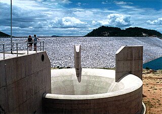
The Osborne Dam site on the Odzi River, Zimbabwe, was identified in the 1950s by the planning engineers of the Ministry of Water. Cored drilling investigations on the two possible alignments were completed in the 1960s. After the completion of Mazvikadei dam [1985–'88] with Italian financial aid, further funding became available for the project and when the 10 000 hectares of potential irrigable land was identified downstream the project was approved in 1989 by the multi-ministry irrigation committee of the Zimbabwe Government.
The Mortlock River is a perennial river in the Wheatbelt region of Western Australia.
The Nambung River is a river in the Wheatbelt region of Western Australia, 170 kilometres (106 mi) north of Perth. The river drains an area between the towns of Cervantes and Badgingarra. In its lower reaches the Nambung River forms a chain of waterholes in the Nambung Wetlands where it disappears underground into a limestone karst system 5.5 kilometres (3 mi) from the Indian Ocean.
The Brockman River is a perennial river located in the Wheatbelt region of Western Australia.
Lake Wooleen is a DIWA-listed intermittent freshwater lake system located in the Mid West region of Western Australia. The lake is situated on Wooleen Station, approximately 148 kilometres (92 mi) north of Yalgoo and 176 kilometres (109 mi) west of Cue.
Lockhart River is a river in the Wheatbelt region of Western Australia. It is a sub-catchment of the Avon River, and has an area of 32,400 square kilometres (12,500 sq mi). At its junction with the Yilgarn River to form the Salt River, it passes through a hydrological-topographical pinch-point at 'Caroline Gap'.
The Avon River, an inland intermittent river of the Wimmera catchment, located in the Grampians and Wimmera regions of the Australian state of Victoria. Rising on the northern slopes of the Great Dividing Range, the Avon River flows north-westerly to reach its confluence with the Richardson River. The rivers of the Wimmera catchment drain into a series of ephemeral lakes that, whilst they do not directly empty into a defined watercourse, form part of the Murray River catchment of the Murray-Darling basin.
The chain of Debsconeag Lakes in the North Maine Woods is a tributary to the West Branch Penobscot River. The flow sequence is from the Sixth Debsconeag Lake through the Fifth, Fourth, Third, Second, and First into the Debsconeag Deadwater on the West Branch.
Yilgarn River is a river in the eastern Wheatbelt region of Western Australia. It is a sub-catchment of the Avon River, and has an area of 55,900 square kilometres (21,600 sq mi). At its junction with Lockhart River, their combined flow passes through a hydrological-topographical pinch-point at Caroline Gap, a geomorphic saddle between Mt Caroline and Mt Stirling.
