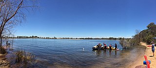
The Avon River is a river in Western Australia. A tributary of the Swan River, the Avon flows 240 kilometres (150 mi) from source to mouth, with a catchment area of 125,000 square kilometres (48,000 sq mi).

The Wheatbelt is one of nine regions of Western Australia defined as administrative areas for the state's regional development, and a vernacular term for the area converted to agriculture during colonisation. It partially surrounds the Perth metropolitan area, extending north from Perth to the Mid West region, and east to the Goldfields–Esperance region. It is bordered to the south by the South West and Great Southern regions, and to the west by the Indian Ocean, the Perth metropolitan area, and the Peel region. Altogether, it has an area of 154,862 square kilometres (59,793 sq mi).

The Division of O'Connor is an Australian electoral division in the state of Western Australia. It is one of Western Australia's three rural seats, and one of the largest electoral constituencies in the world.
County Peak, also known as Mt Quajabin or Quajabin Peak, is located in the western zone of the Wheatbelt region of Western Australia, about 120 km south-east of Perth.

The Avon Wheatbelt is a bioregion in Western Australia. It has an area of 9,517,104 hectares. It is considered part of the larger Southwest Australia savanna ecoregion.
Lake Magenta is an ephemeral salt lake in the Wheatbelt area of Western Australia.
Salt River is a river in the Wheatbelt region of Western Australia. It is a tributary of the Avon River, taking water from two of the Avon's sub-catchments, the Yilgarn River and the Lockhart River, from their junction where it passes through a hydrological-topographical pinch-point at Caroline Gap.
Toolibin Lake is a seasonal fresh to brackish water perched lake or wooded swamp, in south-western Australia. The lake is contained with a 493-hectare (1,218-acre) nature reserve and it is located about 200 kilometres (124 mi) south-east of Perth, in the Shire of Narrogin, and 40 kilometres (25 mi) east of the town of Narrogin, in the Wheatbelt region of Western Australia. The lake is listed by the Australian Government as a threatened ecological community under the Environment Protection and Biodiversity Conservation Act 1999.
The Brockman River is a perennial river located in the Wheatbelt region of Western Australia.
The Mackie River is a river in the Wheatbelt region of Western Australia. The river is ephemeral and flows following winter and spring rains. The water discharged is saline.

The wheatbelt railway lines of Western Australia were, in most cases, a network of railway lines in Western Australia that primarily served the Wheatbelt region.
Lockhart River is a river in the Wheatbelt region of Western Australia. It is a sub-catchment of the Avon River, and has an area of 32,400 square kilometres (12,500 sq mi). At its junction with the Yilgarn River to form the Salt River, it passes through a hydrological-topographical pinch-point at 'Caroline Gap'.

Highways and main roads in the Wheatbelt region of Western Australia form the basis of a road network, which is primarily used by the mining, agriculture, and tourism industries. Main Roads Western Australia maintains and controls these major roads, with offices based in Northam and Narrogin.

Boyagin Rock is located 10 km (6.2 mi) south west of Brookton and 26 km (16 mi) north west of Pingelly in the Wheatbelt region of Western Australia, which is approximately 175 km (109 mi) south east of Perth. The Boyagin Rock outcrop rises 50 m (160 ft) above the surrounding land and is an crestal area of a granite inselberg within the geological Yilgarn Craton framework.

Lake Ewlyamartup is an ephemeral salt lake in the Great Southern region of Western Australia located approximately 17 km (11 mi) east of the town of Katanning and about 294 km (183 mi) south east of Perth.
Coyrecup Lake is an ephemeral salt lake in the Great Southern region of Western Australia located approximately 25 km (16 mi) east of the town of Katanning and about 302 km (188 mi) south east of Perth. The lake is situated within the Coyrecup Nature Reserve, and is part of the Blackwood River drainage basin and the Hardy Estuary-Coblinine River catchment.

Lake Towerrinning or Towerrinning Lake is a permanent brackish lake in the Wheatbelt region of Western Australia located approximately 32 km (20 mi) south of Darkan, 44 km (27 mi) south west of Wagin and about 245 km (152 mi) south east of Perth. The lake is managed by the Department of Parks and Wildlife since it is used as a recreational facility; the Shire of West Arthur leases part of it as a gazetted water ski area.
Lake Baandee, sometimes referred to as Baandee Lake or Baandee Lakes, is an ephemeral salt lake located in the Wheatbelt region of Western Australia, approximately 8 km (5.0 mi) east of Doodlakine and 25 km (16 mi) east of Kelleberrin just off Great Eastern Highway. The town of Hines Hill is also located along the edge of the lake.

Lake Nunijup is an ephemeral salt lake located in the Great Southern region of Western Australia, approximately 27 km (17 mi) south west of Cranbrook and 41 km (25 mi) north west of Mount Barker.
Lake Yealering, also known as Yealering Lakes, is an ephemeral salt lake in the Wheatbelt region of Western Australia located on the southern edge of the town of Yealering, 30 km (19 mi) north west of Wickepin and about 250 km (160 mi) south east of Perth.


