
Admiral Sir James Stirling was a British naval officer and colonial administrator. His enthusiasm and persistence persuaded the British Government to establish the Swan River Colony and he became the first Governor and Commander-in-Chief of Western Australia. In 1854, when Commander-in-Chief, East Indies and China Station, Stirling on his own initiative signed Britain's first Anglo-Japanese Friendship Treaty. Throughout his career Stirling showed considerable diplomatic skill and was selected for a number of sensitive missions. Paradoxically, this was not reflected in his personal dealings with officialdom and his hopes for preferment received many rebuffs. Stirling also personally led the attack in Western Australia on a group of approximately seventy Bindjareb men, women and children now known as the Pinjarra massacre.

John Septimus Roe was the first Surveyor-General of Western Australia. He was a renowned explorer, a member of Western Australia's legislative and executive councils for nearly 40 years, but also a participant in the Pinjarra massacre on 28 October 1834.

Katanning is a town located 277 kilometres (172 mi) south-east of Perth, Western Australia on the Great Southern Highway. At the census of 2021 the population was 4,057. At the 2016 census, Katanning had a population of 3,687.

Great Eastern Highway is a 590-kilometre-long (370 mi) road that links the Western Australian capital of Perth with the city of Kalgoorlie. A key route for road vehicles accessing the eastern Wheatbelt and the Goldfields, it is the western portion of the main road link between Perth and the eastern states of Australia. The highway forms the majority of National Highway 94, although the alignment through the Perth suburbs of Guildford and Midland, and the eastern section between Coolgardie and Kalgoorlie are not included. Various segments form parts of other road routes, including National Route 1, Alternative National Route 94, and State Route 51.
The Kwinana Freeway is a 72-kilometre (45 mi) freeway in and beyond the southern suburbs of Perth, Western Australia, linking central Perth with Mandurah to the south. It is the central section of State Route 2, which continues north as Mitchell Freeway to Clarkson, and south as Forrest Highway towards Bunbury. A 4-kilometre (2.5 mi) section between Canning and Leach highways is also part of National Route 1. Along its route are interchanges with several major roads, including Roe Highway and Mandjoogoordap Drive. The northern terminus of the Kwinana Freeway is at the Narrows Bridge, which crosses the Swan River, and the southern terminus is at Pinjarra Road, east of Mandurah.

The townsite of Tambellup is located in the Great Southern region of Western Australia, 317 km south-east of Perth on the Great Southern Highway where it crosses the Gordon River. It is 23 km south of Broomehill.

Williams is a town located in the Wheatbelt region of Western Australia, 161 kilometres (100 mi) south-southeast of the state capital, Perth along Albany Highway and 32 kilometres (20 mi) west of Narrogin. The Williams River passes through the town. At the 2016 census, Williams had a population of 411.
Tonkin Highway is an 81-kilometre-long (50 mi) north–south highway and partial freeway in Perth, Western Australia, linking Perth Airport and Kewdale with the city's north-eastern and south-eastern suburbs. As of April 2020, the northern terminus is at the interchange with Brand Highway and Great Northern Highway in Muchea, and the southern terminus is at Thomas Road in Oakford. It forms the entire length of State Route 4, and connects to several major roads. Besides Brand Highway and Great Northern Highway, it also connects to Reid Highway, Great Eastern Highway, Leach Highway, Roe Highway, and Albany Highway.

The Gascoyne River is a river in the Gascoyne region of Western Australia. At 865 kilometres (537 mi), it is the longest river in Western Australia.

Jerramungup is a town and locality in the Shire of Jerramungup, Great Southern region of Western Australia. Jerramungup is 454 kilometres (282 mi) southeast of Perth and 6 kilometres (4 mi) west of the Gairdner River.
Charles Cooke Hunt was an English explorer who led four expeditions into the interior of Western Australia between 1864 and 1866.
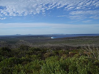
Bremer Bay is a coastal town and locality in the Shire of Jerramungup, Great Southern region of Western Australia. It is situated on the south coast of the state, between Albany and Esperance, at the mouth of the Bremer River. Bremer Bay is 515 kilometres (320 mi) southeast of the state capital, Perth, and 180 kilometres (112 mi) east of Albany. It is on the lands of the Southern Noongar people of the Noongar nation. The claim for Native Title was made in September 2006.
The Beaufort River is a river in the South West region of Western Australia.

The Fitzgerald River is a river in the Great Southern region of Western Australia.

Gairdner River is a river located in the Great Southern region of Western Australia.
The Edmund River is a river in the Gascoyne region of Western Australia.
The Lyons River is a river in the Gascoyne region of Western Australia.
The Gordon River is a river in the Great Southern region of Western Australia.
The Roe River is a river in the Kimberley region of Western Australia.
The May River is a river in the Kimberley region of Western Australia.
