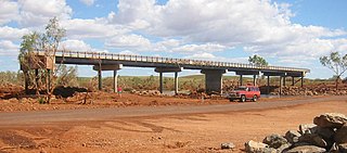
King Edward River

Last updated

King Edward River
King Edward River Falls.jpg
Location
CountryAustralia
Physical characteristics
Source 
  locationPoonjurra Hill
  elevation480 metres (1,575 ft) [1]
Mouth  
  location
Napier Broome Bay
  elevation
sea level
Length221 kilometres (137 mi)
Basin size17,624 square kilometres (6,805 sq mi) [2]

The King Edward River is a river in the Kimberley region of Western Australia.

The headwaters of the river rise below Poonjurra Hill and flows in a northerly direction almost parallel with the Kalumburu Road and eventually discharges into Deep Bay then Napier Broome Bay and finally the Indian Ocean.

The river has seven tributaries, including Carson River, Drum Creek, Noolawayoo Creek, Coondillah Creek and Hair Creek.

The river contains several permanent pools, where examples of Indigenous Australian art known as Bradshaw paintings can be found along the cliff faces. [3]

The river was named in 1901 by the surveyor Frederick Brockman while on expedition in the area. The river is named after King Edward VII, the reigning monarch at the time. [4]

The traditional owners of the areas around the river are the Miwa, Wunambal and Kambure peoples. [5]

Related Research Articles

Kimberley (Western Australia) Region in Western Australia

The Kimberley is the northernmost of the nine regions of Western Australia. It is bordered on the west by the Indian Ocean, on the north by the Timor Sea, on the south by the Great Sandy and Tanami deserts in the region of the Pilbara, and on the east by the Northern Territory.

Bremer River (Queensland)

The Bremer River is a river that is a tributary of the Brisbane River, located in the Scenic Rim and Brisbane regions of South East Queensland, Australia. The 100-kilometre (62 mi)-long Bremer River drains several Scenic Rim valleys in south-east Queensland, including the Fassifern Valley, with its catchment area covering approximately 2,032 square kilometres (785 sq mi). Most valleys within the catchment have extensive river terraces. The Bremer River system is extremely degraded.

Wunaamin Miliwundi Ranges Mountain range in Western Australia

The Wunaamin Miliwundi Ranges, formerly known as the King Leopold Ranges between 1879 and 2020, are a range of hills in the western Kimberley region of Western Australia.

Mary River (Queensland)

The Mary River is a major river system located in the South East and Wide Bay–Burnett regions of Queensland, Australia.

Hill River is a river in the Wheatbelt region of Western Australia.

The Hann River is a river in the Kimberley region of Western Australia.

Drysdale River River in Kimberley region of Western Australia

Drysdale River is a river in the Kimberley region of Western Australia.

The Gibb River is a river in the Kimberley region of northern Western Australia.

The Meda River is a river in the Kimberley region of Western Australia.

Mary River is a river in the Kimberley region of Western Australia.

The Adcock River is a river in the Kimberley region of Western Australia.

The Barton River is a river in the Kimberley region of Western Australia.

King George River River in Western Australia

The King George River is a perennial river located in the Kimberley region of Western Australia.

Prince Regent River River in Kimberley region of Western Australia

The Prince Regent River is a river in the Kimberley region of Western Australia.

The Roe River is a river in the Kimberley region of Western Australia.

Carson River (Western Australia) River in Western Australia

The Carson River is a river in the Kimberley region of Western Australia.

The Fitzroy River, a perennial river of the Glenelg Hopkins catchment, is located in the Western District of Victoria, Australia.

Balla Balla River is a river in the Pilbara region of Western Australia.

The May River is a river in the Kimberley region of Western Australia.

Drysdale River Station Pastoral lease in Western Australia

Drysdale River Station is a pastoral lease that operates as a cattle station in Western Australia.

References

  1. "Bonzle Digital Atlas – Map of King Edward River". 2009. Retrieved 10 July 2016.
  2. "Australian Natural Resources Atlas – Economics – King Edward River". 2009. Archived from the original on 8 August 2008. Retrieved 3 March 2009.
  3. "Bradshaw Foundation – Rock Art Archives". 2010. Retrieved 2 July 2011.
  4. "History of river names – K". Western Australian Land Information Authority. Retrieved 7 September 2011.
  5. "AusAnthrop Australian Aboriginal tribal database". 2012. Archived from the original on 27 September 2015. Retrieved 6 May 2012.

Coordinates: 14°14′3″S126°35′58″E / 14.23417°S 126.59944°E / -14.23417; 126.59944