
The Maribyrnong River is a perennial river of the Port Phillip catchment, located in the north–western suburbs of Melbourne, in the Australian state of Victoria.

The Loddon River, an inland river of the north–central catchment, part of the Murray-Darling basin, is located in the lower Riverina bioregion and Central Highlands and Loddon Mallee regions of the Australian state of Victoria. The headwaters of the Loddon River rise on the northern slopes of the Great Dividing Range east of Daylesford and descend to flow north into the Little Murray River, near Swan Hill. The river is impounded by the Cairn Curran and Laanecoorie reservoirs.
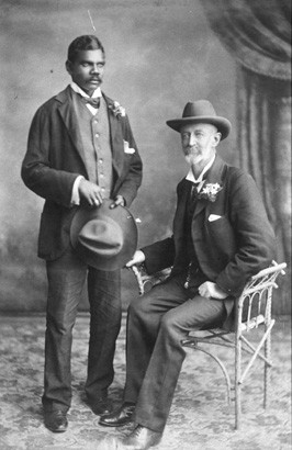
Frank Hugh Hann was an Australian pastoralist and explorer.

The Wunaamin Miliwundi Ranges are a range of hills in the western Kimberley region of Western Australia.

Minilya is a location in Western Australia north of Carnarvon on the North West Coastal Highway. It is at a junction in the North West Coastal Highway, where the turn off to Exmouth is 220 kilometres (140 mi) from that location. The main highway then continues to the next junction 217 kilometres further, at Nanutarra Roadhouse.
The Hann River is a river in the Kimberley region of Western Australia.
Charnley River is a river in the Kimberley region of Western Australia.
Durack River is a river in the Kimberley region of Western Australia.

Drysdale River is a river in the Kimberley region of Western Australia.
The Gibb River is a river in the Kimberley region of northern Western Australia.
The Margaret River is a river in the Kimberley region of Western Australia.
The Meda River is a river in the Kimberley region of Western Australia.

The King Edward River is a river in the Kimberley region of Western Australia.

The Prince Regent River is a river in the Kimberley region of Western Australia.
The Roe River is a river in the Kimberley region of Western Australia.
The Minilya River is a river in the Gascoyne region of Western Australia.

Exmouth Gulf Station or Exmouth Station is a pastoral lease and sheep station located in the Gascoyne region of Western Australia, approximately 50 kilometres (31 mi) south of Exmouth. Occupying an area of 92,364 hectares, the station occupies much of the eastern side of North West Cape; the eastern boundary of the station is the gulf, from which the station takes its name.
The May River is a river in the Kimberley region of Western Australia.
Corunna Downs Station is a pastoral lease that was once a sheep station but now operates as a cattle station in Western Australia.
