
Armadale is a suburb of Perth within the City of Armadale, located on the south-eastern edge of the Perth metropolitan region. The major junction of the South Western and Albany Highways, which connect Perth with the South West and Great Southern regions of Western Australia respectively, is located within the suburb. It is also the terminus of the Armadale railway line, one of five major railway lines to service Perth.

Peppermint Grove is an affluent western suburb of Perth, Western Australia on the north bank of the Swan River at Freshwater Bay. Its local government area, the smallest in the country, is the Shire of Peppermint Grove. The suburb was named after the Swan River peppermint trees lining many streets. The suburb has long been associated with Western Australia's wealthiest and oldest families. Their prosperity is reflected in the many historical houses in the area, such as The Cliffe and the Federation Queen Anne style St Just. Colin Barnett, a former Premier of Western Australia, dubbed the suburb "Monaco of WA" due to its small size and concentration of wealth. It is also known as millionaire’s row and had the highest income of any suburb in Australia in 2022.

Perth railway station is the largest station on the Transperth network, serving the central business district of Perth, Western Australia. It serves as an interchange between the Airport, Armadale, Fremantle, Midland, and Thornlie lines as well as Transwa's Australind service. It is also directly connected to Perth Underground railway station, which has the Joondalup line and Mandurah line.

Coolbellup is a suburb in Perth, Western Australia, located 15 kilometres (9.3 mi) south of the central business district within the local government area of the City of Cockburn.

The Perth Central Area Transit system, or simply CAT, consists of five bus routes in the centre of Perth and three bus routes in Joondalup. CAT services formerly operated in Fremantle, and similar services exist in Rockingham and Midland. Unlike all other Transperth services, most CAT routes are free.

Westfield Booragoon is a major regional shopping centre in the city of Perth, Western Australia. Westfield Booragoon is located at the corner of Marmion Street and Riseley Street in the southern suburb of Booragoon. 50% of the shopping complex is owned by Dexus with the remaining 50% owned by Scentre Group which owns and operates its properties under the Westfield name from which the company is derived.

Bankstown Central is a shopping centre in the suburb of Bankstown in South Western Sydney.
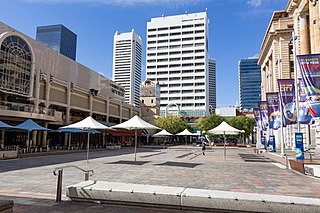
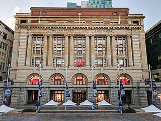
Forrest Place is a pedestrianised square located within the Central Business District of Perth, Western Australia. The street was created in 1923, and has a history of being a focal point for significant political meetings and demonstrations.
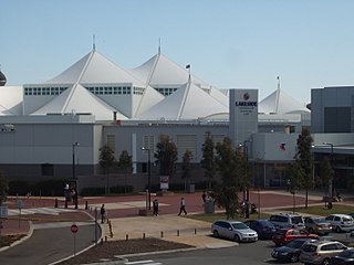
Lakeside Joondalup Shopping City is a major shopping centre located in Joondalup, a suburb in the north of Perth. It is adjacent to the Joondalup railway station, and is currently the third largest shopping centre in Western Australia after Westfield Carousel and Karrinyup Shopping Centre. The centre contains three major Australian supermarkets, Woolworths, Coles and Aldi, three major discount department stores, Big W, Kmart and Target, and the department store Myer.

Stirling is a suburb of Perth, the capital city of Western Australia, about 10 km north of Perth's central business district (CBD) along the Mitchell Freeway. Its local government area is the City of Stirling, whose council offices and administration centre are located in the southwest of the mostly residential suburb.

Karrinyup Shopping Centre is a shopping centre built in 1973 in Karrinyup, a suburb of Perth. The centre is one of the largest shopping centres in Western Australia.

Carillon City was a major Australian shopping centre, located in Perth. It is located in the middle of the Perth main retail precinct between the Hay and Murray Street malls, at the southern end of Forrest Place. It is linked to St Georges Terrace by way of access through Trinity Arcade and an arcade under Hay Street Mall. Walkways and a pedestrian overpass connects the Cultural Centre, public carparks, the rail and bus terminal with Carillon City. As of September 2021 the centre is undergoing redevelopment, involving demolition of the existing centre.

Wellington Street is the northernmost of the four primary east-west streets in the central business district of Perth, Western Australia. It is 3.7 kilometres (2.3 mi) long, stretching from Plain Street in East Perth to Thomas Street in West Perth.

Boans was a department store chain that operated in Perth, Western Australia between from the late 19th century to the late 20th century.
Karingal Hub Shopping Centre as well as its "Town Square" is the second largest shopping complex located at 330 Cranbourne Rd, Frankston, Victoria, Australia, approximately 40 kilometres (25 mi) south of Melbourne CBD. The complex has a combined gross leasable area of 53,000 m2 (570,000 sq ft), 2,750 parking spaces and 200+ stores. It was acquired by ISPT, or the Industry Superannuation Property Trust in July, 2013 and has been owned by other corporations in the past such as Vicinity Centres, which owns its competitor Bayside. It has the only Big W in and around the peninsula and has a multitude of popular shops, and includes a renovated and tall playground within its Town Square as well as an additional smaller playground in the south of the building, close to the retailer Big W.
100 St Georges Terrace is a 24-storey skyscraper located at 100 St Georges Terrace in Perth, Western Australia.
The General Post Office is a heritage landmark building in Perth, Western Australia. Located on the western side of Forrest Place in the city's central business district, its imposing stone facade is in the Beaux-Arts style. The building was completed in 1923 after almost a decade of construction, which was protracted by World War I and the resulting shortages of construction materials. At the time of its opening, it was the largest building in Perth.

Perth is a suburb in the Perth metropolitan region, Western Australia that includes both the central business district of the city, and a suburban area spreading north to the northern side of Hyde Park. It does not include the separate suburbs of Northbridge or Highgate. Perth is split between the City of Perth and the City of Vincent local authorities, and was named after the city of the same name in Scotland.

Midland is a suburb in the Perth metropolitan region, as well as the regional centre for the City of Swan local government area that covers the Swan Valley and parts of the Darling Scarp to the east. It is situated at the intersection of Great Eastern Highway and Great Northern Highway. Midland is almost always regarded as a suburb of Perth, being only 16 km (10 mi) away from the city centre.

Ashfield Mall is a shopping centre in the suburb of Ashfield in the Inner West of Sydney.


