
Padbury Buildings is the name for a range of existing and former structures found in various localities in Western Australia. The Padbury family, mainly Walter Padbury, had a range of buildings, some of which now are heritage listed.
Padbury Buildings is the name for a range of existing and former structures found in various localities in Western Australia. The Padbury family, mainly Walter Padbury, had a range of buildings, some of which now are heritage listed.
In the Perth central business district the Padbury building was on the eastern side of Forrest Place.
In the eastern suburbs of Perth were a number of businesses and buildings in Bassendean, Guildford and Midland; [lower-alpha 1] the company that ran the stores –Padbury Stores –Ltd went into liquidation due to the costs of the Forrest Place building. [2]
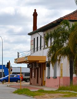
In Bassendean, Padbury Buildings, also Padbury Store, were on Perth Road (now on Guildford Road) immediately across Guildford Road from the Bassendean railway station. [3] [4]
In East Guildford, Padbury Buildings were on Terrace Road, just east of the Rose and Crown Hotel. [5] By 1949 the Guildford Padbury building was owned by C & C. [6]
The names of buildings and business did not necessarily have Padbury as the part of the name. The Guildford store is referred to in 1903 and 1908 as the Colonial Stores. [7] [8]
A number of buildings in Perth were named "Padbury House" at different times.
Part of the Saint Charles Seminary in Guildford has been known as Padbury House. [10]
Padbury House was a building in 1929 on the corner of King Street and St Georges Terrace, Perth. [11]
On the Midland railway line east of Guildford and located in East Guildford, a siding had been in place for William Padbury's Peerless Flour Mill. [12] [lower-alpha 2]
The Swan River is a river in the south west of Western Australia. The river runs through the metropolitan area of Perth, Western Australia's capital and largest city.

Bassendean is a north-eastern suburb of Perth, Western Australia. Its local government area is the Town of Bassendean.

Great Eastern Highway is a 590-kilometre-long (370 mi) road that links the Western Australian capital of Perth with the city of Kalgoorlie. A key route for road vehicles accessing the eastern Wheatbelt and the Goldfields, it is the western portion of the main road link between Perth and the eastern states of Australia. The highway forms the majority of National Highway 94, although the alignment through the Perth suburbs of Guildford and Midland, and the eastern section between Coolgardie and Kalgoorlie are not included. Various segments form parts of other road routes, including National Route 1, Alternative National Route 94, and State Route 51.
The Midland line is a suburban railway and service on the Transperth Train Operations network in Perth, Western Australia. It runs on the Eastern Railway through Perth's eastern suburbs and connects Midland with Perth. Travelling from Midland, the trains terminate at Fremantle on the Fremantle line.
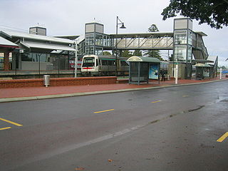
Bassendean railway station is a Transperth station located in Bassendean, 10.8 kilometres (6.7 mi) north-east of Perth railway station, on the Midland Line.

The Swan View Tunnel is a former railway tunnel located on the southern side of the Jane Brook valley in the outer Perth suburb of Swan View in the John Forrest National Park on the edge of the Darling Scarp. After its closure as a railway tunnel, it reopened as part of the John Forrest Heritage Trail, a rail trail.
Western Australian Government Railways (WAGR) was the operator of railway services in the state of Western Australia between October 1890 and June 2003. Owned by the state government, it was renamed a number of times to reflect extra responsibility for tram and ferry operations that it assumed and later relinquished. Its freight operations were privatised in December 2000 with the remaining passenger operations transferred to the Public Transport Authority in July 2003.

Ellenbrook is a northeastern suburb of Perth, Western Australia, about 30 km (19 mi) from Perth's central business district (CBD), located within the City of Swan. Ellenbrook, and its neighbouring suburbs of The Vines and Aveley, are unusual for Perth in being a significant distance from neighbouring suburbs. Given this relative isolation and the distance from the CBD, Ellenbrook has been designed and developed as a self-sustainable community. Since the upgrade of Gnangara Road and the completion of the Tonkin Highway Northlink, access to Ellenbrook has improved. The Morley–Ellenbrook railway line is well underway as at June 2021 and this will enable better public transport. At the time of the 2016 census there were 22,681 people living in the gazetted suburb, by June 2018, it was estimated that the urban population for Ellenbrook and surrounds had grown to 41,382. It is envisioned that Ellenbrook will eventually become a satellite city, with a population of 80,000.

The Town of Bassendean is a local government area in the northeastern suburbs of the Western Australian capital city of Perth, 6 kilometres (4 mi) west of the industrial centre of Midland and about 12 kilometres (7 mi) northeast of Perth's central business district. The Town covers an area of 10.4 square kilometres (4.0 sq mi), maintains 97 km of roads and had a population of approximately 15,000 as at the 2016 Census. The Town of Bassendean is a member of the Eastern Metropolitan Regional Council.

Bayswater is a suburb 6 km (4 mi) north-east of the central business district (CBD) of Perth, the capital of Western Australia. It is just north of the Swan River, within the City of Bayswater local government area. It is predominantly a low-density residential suburb consisting of single-family detached homes. However, there are several clusters of commercial buildings, most notably in the suburb's town centre, around the intersection of Whatley Crescent and King William Street and a light industrial area in the suburb's east.
Transport in Perth, Western Australia, is served by various means, among them an extensive highway / freeway network and a substantial system of commuter rail lines and bus routes. Public transport is managed by the Transperth agency.

Guildford Cemetery is a cemetery in the southern part of South Guildford, Western Australia, located between the Great Eastern Highway Bypass and Kalamunda Road adjacent to the Perth Airport.
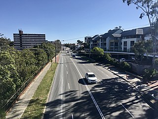
Guildford Road is a major road in Perth, Western Australia, linking the inner-city suburb of Mount Lawley with Guildford in the north-east. The ten-kilometre-long (6.2 mi) road runs mostly parallel to the Swan River, on its northern side, and is part of State Route 51, which runs between Perth's CBD and Midvale. Guildford Road is maintained and controlled by Main Roads Western Australia, which uses the internal designation "H026 Guildford Road" for Guildford Road, as well as Bridge Street and James Street in Guildford. In the 1930s, the name Great Eastern Highway was coined to describe the road, but was actually used for the road on the other side of the Swan River.
The Belmont Railway Line was a branch railway in Western Australia that extended from the Eastern Railway at Bayswater to Belmont near the Ascot Racecourse. The line closed in 1956.
Darling Range Hotel was a hotel in Bellevue, Western Australia, on the end of the slope on the Great Eastern Highway at the 'bottom of' Greenmount Hill and just north of the former Bellevue railway station, and over the road from the Helena Vale Racecourse.

The Mount Helena Tavern was opened in 1902 in Mount Helena, a hills suburb of Perth, Western Australia. It was originally called the Lion Mill Hotel, then the Mount Helena Hotel, before acquiring its current name. Locally it is referred to as The Mounties.

The Mundaring Hotel was opened in 1899 in Mundaring, a hills suburb of Perth, Western Australia.

The Padbury Buildings was a building complex in Forrest Place in Perth, Western Australia. It was located the full length of Forrest Place between Wellington Street and Murray Street. They were constructed in 1924–1925.
The Municipality of Guildford was a local government area of Western Australia. It first came into existence in 1838 as the Guildford Town Trust, before ceasing to function several years later. It was reconstituted in 1863, and became a Municipality in 21 February 1871 under the Municipal Institutions Act. It ceased to exist when it was merged with the Swan Road District on 10 June 1960 to form the Swan-Guildford Road District.