
Perth is the capital city of Western Australia. It is the fourth most populous city in Australia, with a population of over 2.3 million within Greater Perth as of 2023. It is part of the South West Land Division of Western Australia, with most of Perth's metropolitan area on the Swan Coastal Plain between the Indian Ocean and the Darling Scarp. The city has expanded outward from the original British settlements on the Swan River, upon which its central business district and port of Fremantle are situated.
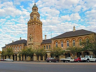
Kalgoorlie is a city in the Goldfields–Esperance region of Western Australia, located 595 km (370 mi) east-northeast of Perth at the end of the Great Eastern Highway. It is sometimes referred to as Kalgoorlie–Boulder, as the surrounding urban area includes the historic townsite of Boulder and the local government area is the City of Kalgoorlie–Boulder.

Mandurah is a coastal city in the Australian state of Western Australia, situated approximately 72 kilometres (45 mi) south of the state capital, Perth. It is the state's second most populous city, with a population of 90,306.
Murray Street is one of four main east-west streets within the Perth central business district (CBD).

Barrack Street is one of two major cross-streets in the central business district of Perth, Western Australia. Together with St Georges Terrace, Wellington Street and William Street it defines the boundary of the main shopping precinct of the central city.

Westfield Booragoon is a major regional shopping centre in Perth, Western Australia. It is located at the corner of Marmion and Riseley streets in the southern suburb of Booragoon. Dexus and Scentre Group each own 50%.

The Horseshoe Bridge in Perth, Western Australia is a traffic bridge that connects the Perth CBD to Northbridge, carrying William Street. It was constructed in 1904 to pass over the Fremantle railway line, with the horseshoe shape designed to fit the approach ramps into a constricted site.

Fast Eddys was a fast food and restaurant chain that primarily operated in Perth, Western Australia, and also briefly in Adelaide, South Australia, Cairns, Queensland, Melbourne, Victoria, as well as in New South Wales. Fast Eddys was most notable at the time of its establishment for being one of the few Perth restaurants open 24 hours a day, 7 days a week including public holidays.
West Perth is an inner suburb of Perth, the capital city of Western Australia.

Hay Street is a major road through the central business district of Perth, Western Australia and adjacent suburbs. The street was named after Robert William Hay, the Permanent Under Secretary for Colonies. Sections of the road were called Howick Street and Twiss Street until 1897. One block in the central business section is now a pedestrian mall with extremely limited vehicular traffic, so that it is necessary to make a significant detour in order to drive the entire length of Hay Street.

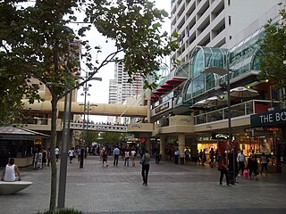
Carillon City was a major Australian shopping centre, located in Perth. It is located in the middle of the Perth main retail precinct between the Hay and Murray Street malls, at the southern end of Forrest Place. It is linked to St Georges Terrace by way of access through Trinity Arcade and an arcade under Hay Street Mall. Walkways and a pedestrian overpass connects the Cultural Centre, public carparks, the rail and bus terminal with Carillon City. As of September 2021 the centre is undergoing redevelopment, involving demolition of the existing centre.

London Court is a four-level mock Tudor open shopping arcade located in the central business district of Perth, Western Australia. It was built in 1937 by wealthy gold financier and businessman Claude de Bernales for residential and commercial purposes. The arcade runs between the Hay Street Mall and St Georges Terrace and is considered an important tourist attraction in the Perth CBD. It received a National Trust of Australia classification in 1978 and was recorded in the Register of the National Estate in 1982. The Heritage Council of Western Australia included it in the State Heritage Register in 1996.

QV1 is a 40-storey modernist skyscraper in Perth, Western Australia. Completed in 1991, the 163-metre (535 ft) building is the fourth-tallest building in Perth, after Central Park, Brookfield Place and 108 St Georges Terrace. The project was designed by architect Harry Seidler & Associates and has won numerous awards for its innovative design and energy efficiency.
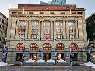
The General Post Office is a heritage landmark building in Perth, Western Australia. Located on the western side of Forrest Place in the city's central business district, its imposing stone facade is in the Beaux-Arts style. The building was completed in 1923 after almost a decade of construction, which was protracted by World War I and the resulting shortages of construction materials. At the time of its opening, it was the largest building in Perth.
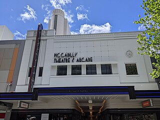
The Piccadilly Cinema Centre and Piccadilly Arcade are located at 700-704 Hay Street, Perth, Western Australia. It is an art deco style cinema and shopping arcade, designed by architect William T. Leighton for mining entrepreneur Claude de Bernales. The theatre and arcade opened in 1938, with the arcade connecting Hay Street through to Murray Street.
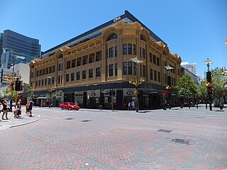
Walsh's Building formerly known as the Economic Store Building is a building in Perth, Western Australia. It was designed by Talbot Hobbs.
Tourism in Perth, the capital city of Western Australia, is an important part of the Australian state's economy, contributing to the prosperity of businesses in the city, as well as other regions of the state.
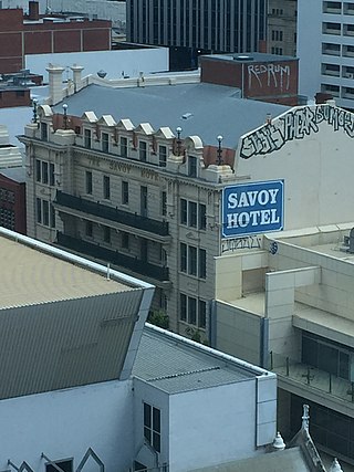
The Savoy Hotel is a heritage-listed former hotel in Hay Street, Perth, Western Australia. It was built in the 1910s and closed in 1991. It is listed on the State Register of Historic Places, has been classified by the National Trust of Australia, and was listed on the former Register of the National Estate.

Northbridge is an inner city suburb of Perth, Western Australia, historically separated from Perth's central business district by the Fremantle and Joondalup railway lines. It is part of the City of Perth local government area.
The lanes and arcades of Perth, Western Australia are collectively becoming culturally important to the city.

