
Royal Perth Hospital (RPH) is a 450-bed adult and teaching hospital located on the northeastern edge of the central business district of Perth, Western Australia.
Murray Street is one of four main east-west streets within the Perth central business district (CBD).

Barrack Street is one of two major cross-streets in the central business district of Perth, Western Australia. Together with St Georges Terrace, Wellington Street and William Street it defines the boundary of the main shopping precinct of the central city.

St Georges Terrace is the main street in the city of Perth, Western Australia. It runs parallel to the Swan River and forms the major arterial thoroughfare through the central business district.

A coffee palace was an often large and elaborate residential hotel that did not serve alcohol, most of which were built in Australia in the late 19th century.

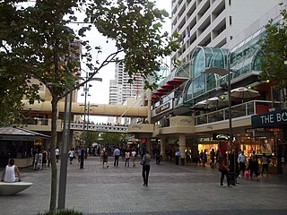
Hay Street is a major road through the central business district of Perth, Western Australia and adjacent suburbs. The street was named after Robert William Hay, the Permanent Under Secretary for Colonies. Sections of the road were called Howick Street and Twiss Street until 1897. One block in the central business section is now a pedestrian mall with extremely limited vehicular traffic, so that it is necessary to make a significant detour in order to drive the entire length of Hay Street.

Wellington Street is the northernmost of the four primary east-west streets in the central business district of Perth, Western Australia. It is 3.7 kilometres (2.3 mi) long, stretching from Plain Street in East Perth to Thomas Street in West Perth.

William Street is a suburban distributor and one of two major cross-streets in the central business district of Perth, Western Australia. Commencing in western Mount Lawley, its route takes it through the Northbridge café and nightclub district as well as the CBD.
Victoria Avenue is a street in the central business district of Perth, Western Australia.

Perth is a suburb in the Perth metropolitan region, Western Australia that includes both the central business district of the city, and a suburban area spreading north to the northern side of Hyde Park. It does not include the separate suburbs of Northbridge or Highgate. Perth is split between the City of Perth and the City of Vincent local authorities, and was named after the city of the same name in Scotland.

The Perth tramway network served Perth, the capital city of Western Australia, from 1899 until 1958. The network was initially run by a private company but was taken over by the state government in 1913. From a single line along Hay Street, the network expanded north as far as Osborne Park, east as far as Welshpool, south as far as Como, and west as far as Claremont. The tramways were gradually replaced by buses after World War II.

The Swan River Mechanics' Institute was the Swan River Colony's first cultural centre, established on 21 January 1851. In time it was to house an extensive and well-used subscription library and a natural history collection, including botanical, zoological and mineral specimens. A new building replaced the old in 1899, and in 1909 the institute was renamed Perth Literary Institute.

Sherwood Court is a short sloping road between St Georges Terrace in Perth, Western Australia and The Esplanade with Allendale Square on the upper corner, and Lawson Apartments on the lower.
Tourism in Perth, the capital city of Western Australia, is an important part of the Australian state's economy, contributing to the prosperity of businesses in the city, as well as other regions of the state.

Milligan Street is a street in Perth, Western Australia that runs from St Georges Terrace to north of Wellington Street. The northern section provides access to the Perth Arena carpark and Telethon Avenue; there are also dedicated Transperth bus roads connecting to the northern end, south of the Fremantle railway line.

The City of Perth Library is a public library service provided by the City of Perth. The library is located on Hay Street, next to the Perth Town Hall. It is part of the redevelopment of Cathedral Square, located between St Georges Terrace and Hay, Barrack and Pier Streets.

Cathedral Square is a precinct in the central business district of Perth, Western Australia, bounded by Hay Street to the north, Pier Street to the east, St Georges Terrace to the south, and Barrack Street to the west.
Victoria Square is the name of the area and road that runs around the edge of the grounds of St Mary's Cathedral in Perth, Western Australia.
Lord Street is a road in East Perth, Western Australia. It starts from Victoria Square near Royal Perth Hospital and runs north-east for 2.1 kilometres (1.3 mi) to end at Walcott Street, Mount Lawley.
