
Mount Lawley is an inner northern suburb of Perth, Western Australia. The suburb is bounded by the Swan River to the east, Vincent, Harold and Pakenham Streets to the south, Central Avenue and Alexander Drive to the north, and Norfolk Street to the west.
The Town of Victoria Park is a local government area of Western Australia. It covers an area of 17.62 km² in metropolitan Perth, the capital of Western Australia. It had a population of approximately 35,000 as at the 2016 Census.

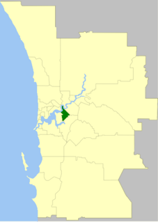
The City of Vincent is a local government area of Western Australia. It covers an area of approximately 10.4 square kilometres (4.0 sq mi) in metropolitan Perth, the capital of Western Australia, and lies about 3 km from the Perth CBD. The City of Vincent maintains 139 km of roads and 104 ha of parks and gardens. It had a population of over 33,000 at the 2016 Census.
Darra is a south-western suburb in the City of Brisbane, Queensland, Australia. In the 2016 census, Darra had a population of 4,343 people.

Pinkenba is a town and eastern coastal suburb within the City of Brisbane, Queensland, Australia. In the 2016 census, Pinkenba had a population of 368 people.

Camp Hill is an eastern suburb in the City of Brisbane, Queensland, Australia. In the 2021 census, Camp Hill had a population of 12 145 people.
McDowall is an outer northern suburb in the City of Brisbane, Queensland, Australia. In the 2016 census, McDowall had a population of 7,237 people.

Barrack Street is one of two major cross-streets in the central business district of Perth, Western Australia. Together with St Georges Terrace, Wellington Street and William Street it defines the boundary of the main shopping precinct of the central city.

East Brisbane is an inner southern suburb of the City of Brisbane, Queensland, Australia. In the 2016 census, East Brisbane had a population of 5,934 people.

Rockhampton City is the central suburb of the city of Rockhampton in the Rockhampton Region, Queensland, Australia. In the 2016 census. Rockhampton City had a population of 1,953 people. It is informally known as Rockhampton central business district (CBD).

Sherwood is a suburb in the City of Brisbane, Queensland, Australia. In the 2016 census, Sherwood had a population of 5,313 people.

William Street is a suburban distributor and one of two major cross-streets in the central business district of Perth, Western Australia. Commencing in western Mount Lawley, its route takes it through the Northbridge café and nightclub district as well as the CBD.

Beaufort Street is a major road in the inner north-eastern suburbs of Perth, Western Australia, connecting the Morley area to the Perth central business district. For most of its length, it is a single-carriageway, two-way road with two lanes in each direction.
The Perth Cultural Centre is an area of central Perth, Western Australia, near the James Street Mall.

The City of Brisbane is a local government area (LGA) which comprises the inner portion of the metropolitan area of Brisbane, the capital of Queensland, Australia. Its governing body is the Brisbane City Council. Unlike LGAs in the other mainland state capitals, which are generally responsible only for the central business districts and inner neighbourhoods of those cities, the City of Brisbane administers a significant portion of the Brisbane metropolitan area, serving almost half of the population of the Brisbane Greater Capital City Statistical Area (GCCSA). As such, it has a larger population than any other local government area in Australia. The City of Brisbane was the first Australian LGA to reach a population of more than one million. Its population is roughly equivalent to the populations of Tasmania, the Australian Capital Territory and the Northern Territory combined. In 2016–2017, the council administered a budget of over $3 billion, by far the largest budget of any LGA in Australia.
Pier Street is a street in the central business district of Perth, Western Australia. It runs from St Georges Terrace to Wellington Street, continuing immediately north of the railway until Brisbane Street very close to where Brisbane Street meets Bulwer Street.
Charles Street is a major road in the inner northern suburbs of Perth, Western Australia. It runs from Newcastle Street and extends up to London Street, providing a connection between Mitchell Freeway and Wanneroo Road. It is the southern section of part of State Route 60, which continues north along Wanneroo Road.
Aberdeen Street is a street in the Perth suburbs of Perth and Northbridge that runs from a cul-de-sac west of Lord Street in the east to a cul-de-sac between Fitzgerald Street and the Mitchell Freeway in the west. The street has 42 locally listed places of significance, 18 of which are also listed on the State Register of Heritage Places.
Astone Lane was originally a right of way running between Brisbane Street and Baker Avenue in Perth, Western Australia. A proposal to name the right of way as Astone Lane was considered at the Town of Vincent council meeting in September 2006. The naming of the lane was in honour of Antonino Astone, a migrant from Raccuia, Sicily, who established a bootmaker business nearby on the corner of Brisbane and William Streets. Astone was a well-known identity in the community, and a pioneer in assisting migrants who arrived in Fremantle after World War II, many of them settling into the area.
