Walter Road

Last updated

Walter Road

  • Walter Road West
  • Walter Road East

Walter Road at Rosebery Street, Bedford-Dianella border, Western Australia 01.jpg
Walter Road West near Rosebery Street
Walter Road
General information
TypeRoad
Length8.3 km (5.2 mi) [1]
Major junctions
Walter Road West
West endHamer Parade Inglewood
 
East end Cul-de-sac Morley
Walter Road East
West endAustralian state route 53.svg Beechboro Road North / Australian state route 53.svg Broun Avenue Embleton / Bayswater / Morley
East endLord Street Bassendean / Eden Hill
Location(s)
Major suburbs Inglewood, Dianella, Bedford, Morley , Bayswater, Bassendean, Eden Hill

Walter Road is a road in the north-eastern suburbs of Perth, Western Australia. Formerly a continuous road, it is now discontinuous at Tonkin Highway. The western section of the road is known as Walter Road West, and the eastern section of the road is known as Walter Road East.

Contents

Route description

Walter Road has a speed limit of 60 kilometres per hour (37 mph) for its entire length. [2]

Walter Road West

Walter Road West, which is 5.5 kilometres (3.4 mi) long, [1] commences as a four lane continuation of Hamer Parade. 200 metres (660 ft) to the south-west, Hamer Parade terminates at a roundabout intersection with Central Avenue. From Hamer Parade, Walter Road West heads north, between Mount Lawley Golf Club and Walter Road Reserve. The road then bends to the north-east, passing through the urban areas of Inglewood, Dianella, and Bedford. The traffic light controlled intersections on this section are Dundas Road and Homer Street, Grand Promenade and Coode Street.

Approximately 3 kilometres (1.9 mi) after its western terminus, Walter Road West enters the Morley commercial district. To the south is the Galleria Shopping Centre, and to the north is Coventry Village. The road takes a bend to face it due east. Traffic light controlled intersections on this section are Russell Street, Wellington Road and Collier Road.

Walter Road West then exits the Morley commercial district after Collier Road, passing through housing in Morley. After the intersection with Crimea Street, which is a traffic light controlled intersection, Walter Road West is a two lane road. Near the road's eastern terminus, there is a roundabout with Embleton Avenue. Just to the east of the roundabout, Walter Road West terminates at a cul-de-sac. To the south of the roundabout, Embleton Avenue leads to Broun Avenue, which bridges over Tonkin Highway, leading to Walter Road East.

Walter Road East

Walter Road East near Abingdon Street Walter Road East near Abingdon Street, Western Australia.jpg
Walter Road East near Abingdon Street

Walter Road East, which is 2.8 kilometres (1.7 mi) long, [1] commences as a four lane continuation of Broun Avenue at the intersection of Beechboro Road North. From there, the Road heads due east along the border of Bayswater / Morley, and later Bassendean / Eden Hill. Walter Road East briefly reduces to two lanes at the roundabout with Iolanthe Street, but otherwise remains a four lane road. The only set of traffic lights between the two termini is with Ivanhoe Street. The eastern terminus of Walter Road East is with Lord Street. There is a small, 100 metres (330 ft) section of Walter Road east of the Lord Street terminus that is cut off from the rest of the road.

History

A track on the boundary of Q1 and P is the earliest sign of Walter Road Ribbon grants of the Bayswater area, Swan River Colony.png
A track on the boundary of Q1 and P is the earliest sign of Walter Road

The earliest sign of what is now Walter Road was in the 1880s, as a track that followed the boundary of land grants Q1 and P. In 1887, the Perth Road Board decided to link the track to Perth. The route taken by the track is roughly the present day route of Walter Road, and it was used as an alternative route to reach West Guildford (now Bassendean). It was at first known as Government Road. [3] :37

At some point in the early 20th century, the track was made into a plank road. [3] :73 A small rural community named Morley Park developed on Government Road. The Morley that exists today bears no visual signs of this early development. [3] :181 In May 1932, the Bayswater Road Board submitted an application for Commonwealth funding for widening and improving Government Road as a way of creating employment during the Great Depression. The works occurred during 1932 and the start of 1933. [3] :168

In 1944, the Main Roads Department renamed Government Road to Walter Road. There are conflicting reports as to the origin of the name. One option is Walter Browne, who was born in Bayswater in 1903 and lived there for some time. [3] :204 [4] Another possibility is Edgar Walter Hamer, who worked for Gold Estates, a property development company, and was Chairman of the Perth Road Board (precursor to the City of Stirling). [5] Another possibility is Walter Padbury, who was a pioneer and politician. [6]

In the 1960s, it was decided that Walter Road would be split into two when the planned Beechboro-Gosnells Highway was built. This was in line with the vision of Walter Road to be serving the Morley business district, rather than a through road. [3] :266 The highway, now named Tonkin Highway, was built in the early 1980s, splitting Walter Road into two sections. A bridge across Tonkin Highway was instead built at Broun Avenue just to the south of Walter Road. A small section of what used to be Walter Road is now Cherry Court. [7]

In the mid 2010s, the City of Bayswater proposed to widen the section of Walter Road that goes through the Morley Activity Centre by 4.9 metres (16 ft) on both sides, in order to add a shared bus and cycling lane. This was later revised to 2 metres (6 ft 7 in), and then ditched altogether after opposition, particularly by the owners of Coventry Village, who would have had their outdoor dining area removed. [8] [9]

Junction list

Walter Road West

LGA [10] [11] LocationkmmiDestinationsNotes
Stirling Inglewood 00.0Hamer Parade  Mount Lawley, Inglewood Walter Road West terminus; road continues south-west as Hamer Parade, with Hamer Parade branching off to the east
0.80.50Dundas Road south-east / Homer Street north-west  Dianella, Inglewood Traffic light controlled intersection
Stirling–Bayswater boundary BedfordDianella boundary1.60.99Australian state route 53.svg Grand Promenade   Bayswater, Bedford, Dianella Traffic light controlled intersection
Bedford–Dianella–Morley tripoint2.61.6Coode Street  Bayswater, Bedford, Dianella Traffic light controlled intersection
Bayswater Morley3.22.0Russell Street  Morley Traffic light controlled intersection
3.52.2Old Collier Road south-east / Wellington Road north-west  Dianella, Morley Traffic light controlled intersection
4.02.5 Collier Road   Morley, Embleton, Bayswater, Bassendean Traffic light controlled intersection
4.22.6Crimea Street  Morley, Noranda Traffic light controlled intersection
5.13.2Bath Road  Morley, Noranda
5.43.4Embleton Avenue  Embleton, Bayswater Roundabout
5.53.4 Cul-de-sac Walter Road West terminus

Walter Road East

LGA [11] [12] LocationkmmiDestinationsNotes
Bayswater BayswaterEmbletonMorley tripoint00.0Australian state route 53.svg Beechboro Road North north and south / Australian state route 53.svg Broun Avenue west  Perth, Bayswater, Morley, Beechboro Walter Road East terminus; road continues west as Broun Avenue; traffic light controlled intersection
Bassendean BassendeanEden Hill border1.71.1Iolanthe Street  Bassendean, Eden Hill Roundabout
2.11.3Ivanhoe Street  Bassendean, Eden Hill Traffic light controlled intersection
2.81.7Lord Street  Bassendean, Eden Hill, Lockridge, Beechboro Walter Road East terminus; traffic light controlled intersection

See also

Related Research Articles

<span class="mw-page-title-main">Division of Cowan</span> Australian federal electoral division

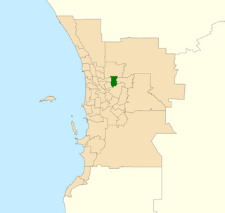
The Division of Cowan is an Australian Electoral Division in Western Australia.

Embleton is a suburb of Perth, the capital city of Western Australia, located 7 kilometres (4.3 mi) north-east of the central business district, between the suburbs of Morley and Bayswater. Its local government area is the City of Bayswater.

<span class="mw-page-title-main">Wanneroo Road</span> Road in Perth, Western Australia

Wanneroo Road is a 44-kilometre (27 mi) arterial highway in the northern suburbs of Perth, Western Australia linking Joondanna and Yokine in the south with Wanneroo and Yanchep in the north. As part of State Route 60, it begins from Charles Street in the inner city and becomes Indian Ocean Drive up to Dongara.

<span class="mw-page-title-main">Tonkin Highway</span> Highway in Perth, Western Australia

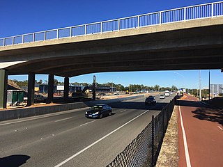
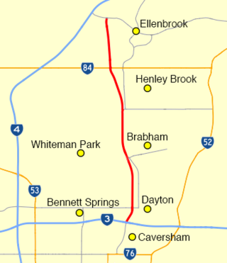
Tonkin Highway is an 81-kilometre-long (50 mi) north–south highway and partial freeway in Perth, Western Australia, linking Perth Airport and Kewdale with the city's north-eastern and south-eastern suburbs. As of April 2020, the northern terminus is at the interchange with Brand Highway and Great Northern Highway in Muchea, and the southern terminus is at Thomas Road in Oakford. It forms the entire length of State Route 4, and connects to several major roads. Besides Brand Highway and Great Northern Highway, it also connects to Reid Highway, Great Eastern Highway, Leach Highway, Roe Highway, and Albany Highway.

<span class="mw-page-title-main">Electoral district of Bassendean</span> State electoral district in Perth, Western Australia

Bassendean is an electoral district of the Legislative Assembly in the Australian state of Western Australia.

<span class="mw-page-title-main">Bayswater, Western Australia</span> Suburb of Perth, Western Australia

Bayswater is a suburb 6 km (4 mi) north-east of the central business district (CBD) of Perth, the capital of Western Australia. It is just north of the Swan River, within the City of Bayswater local government area. It is predominantly a low-density residential suburb consisting of single-family detached homes. However, there are several clusters of commercial buildings, most notably in the suburb's town centre, around the intersection of Whatley Crescent and King William Street and a light industrial area in the suburb's east.

<span class="mw-page-title-main">Alexander Drive</span> Road in Perth, Western Australia

Alexander Drive is a major north–south arterial road in the northern suburbs of Perth, Western Australia, connecting Perth's central business district (CBD) with Edith Cowan University's Mount Lawley campus and the Malaga industrial area, as well as newer development suburbs to Perth's north. It is used by Transperth bus routes, including the 360, 361 and 362. Alexander Drive was named after Mr S.B. Alexander, a former Wanneroo Road Board member. Alexander Drive runs through the following local government areas City of Wanneroo, City of Swan, City of Bayswater and City of Stirling.

<span class="mw-page-title-main">Beechboro Road</span> Road in Perth, Western Australia

Beechboro Road is a north–south arterial road located in the northeastern suburbs of Perth, Western Australia, connecting Morley and Bayswater with areas further north. Until the construction of the nearby section of Tonkin Highway between 1984 and 1992, and later, during the NorthLink WA road project between 2016 and 2019, Beechboro Road was one of northeastern Perth's most important routes. The road is discontinuous at Tonkin Highway, with the section from Tonkin Highway to Walter Road officially known as Beechboro Road North, and the section running through Bayswater as Beechboro Road South.

<span class="mw-page-title-main">Hepburn Avenue</span> Road in Perth, Western Australia

Hepburn Avenue is an arterial east-west road in the northern suburbs of Perth, Western Australia. The road links Sorrento in the west with Malaga and Whiteman in the east. It also connects the residential developments that span its length with several local facilities, as well as major road routes into central Perth.

<span class="mw-page-title-main">Beaufort Street</span> Road in Perth, Western Australia

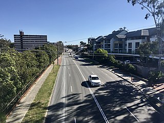
Beaufort Street is a major road in the inner north-eastern suburbs of Perth, Western Australia, connecting the Morley area to the Perth central business district. For most of its length, it is a single-carriageway, two-way road with two lanes in each direction.

<span class="mw-page-title-main">Morley Drive</span>

Morley Drive is a major east-west road in the inner northern suburbs of Perth, Western Australia, connecting the residential areas of Balcatta, Osborne Park, Tuart Hill, Nollamara, Yokine, Dianella, and Morley with major north-south arterial roads including Wanneroo Road, Alexander Drive, and Tonkin Highway.

<span class="mw-page-title-main">Gnangara Road</span> Road in Perth, Western Australia

Gnangara Road is an arterial east-west road in Perth, Western Australia. It is located within the northern suburbs of Perth, from Madeley in the west, to Henley Brook in the east. Gnangara Road provides a connection between Great Northern Highway and Wanneroo Road. The construction of the Ocean Reef Road extension in 2011 altered the road network in the Landsdale area in Landsdale. The plans show Gnangara Road as discontinuous between Mirrabooka Avenue and Alexander Drive, with the Mirrabooka Avenue and Ocean Reef Road extensions linking the two sections. Following construction, those linking road sections were named as Gnangara Road, allowing the road to remain continuous.

<span class="mw-page-title-main">Guildford Road</span> Road in Perth, Western Australia

Guildford Road is a major road in Perth, Western Australia, linking the inner-city suburb of Mount Lawley with Guildford in the north-east. The ten-kilometre-long (6.2 mi) road runs mostly parallel to the Swan River, on its northern side, and is part of State Route 51, which runs between Perth's CBD and Midvale. Guildford Road is maintained and controlled by Main Roads Western Australia, which uses the internal designation "H026 Guildford Road" for Guildford Road, as well as Bridge Street and James Street in Guildford. In the 1930s, the name Great Eastern Highway was coined to describe the road, but was actually used for the road on the other side of the Swan River.

NorthLink WA was a road construction project in Perth, Western Australia, that saw both the northern section of Tonkin Highway upgraded, and the road extended northwards as the Swan Valley Bypass, to bypass Great Northern Highway. These two component projects were separately funded, with both the state and federal governments contributing to each project. Construction commenced in June 2016 and was completed on 23 April 2020.

<span class="mw-page-title-main">Grand Promenade (Perth)</span>

Grand Promenade is a 5-kilometre main road in the inner north-eastern suburbs of Perth, Western Australia, linking Dianella in the north, with Bayswater in the south. It forms the northern section of State Route 55 connecting with Railway Parade, which it joins onto at its southern terminus.

<span class="mw-page-title-main">Collier Road</span> Road in Perth, Western Australia

Collier Road is a 4.7-kilometre (2.9 mi) main road in the north-eastern suburbs of Perth, Western Australia, linking Morley in the north-west to Bassendean in the south-east. It services an industrial area in Bayswater and Bassendean, the Morley business district, and connects to Tonkin Highway. Collier Road first existed as a gravel track in the 1910s. The 1950s and 1960s saw the land around Collier Road change from rural to urban. It has undergone a major realignment twice, first in the mid-1980s to make room for a larger shopping centre in Morley, and between 2016 and 2018, for the construction of an interchange with Tonkin Highway.

<span class="mw-page-title-main">Morley railway station, Perth</span> Proposed railway station in Perth, Western Australia

Morley railway station is a bus and railway station under construction as part of the Metronet Morley–Ellenbrook Line, serving the Perth suburbs of Bayswater, Embleton and Morley. It is to be built in the median strip of Tonkin Highway at Broun Avenue.

<span class="mw-page-title-main">Benara Road</span> Road in Perth, Western Australia

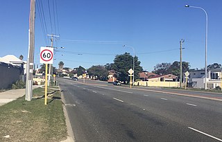
Benara Road is an east–west road in the north-eastern suburbs of Perth, Western Australia.

<span class="mw-page-title-main">Drumpellier Drive</span>

Drumpellier Drive is a north-south road linking Ellenbrook with Reid Highway in the north-eastern suburbs of Perth. The southern section was opened as Lord Street, and was the main link between Ellenbrook and the rest of Perth until the extension of Tonkin Highway north to Gnangara Road. The road corridor has had several proposals put forward for it, including a highway, a bus rapid transit road and a railway. In 2019, a new alignment for Lord Street south of Gnangara Road opened, and it was renamed to Drumpellier Drive, making the naming consistent with the section of road north of Gnangara Road.

<span class="mw-page-title-main">Marshall Road</span>

Marshall Road is an east-west road in the northern suburbs of Perth, Western Australia. It is continuous with Beach Road.

References

  1. 1 2 3 "Google Maps". Google. Archived from the original on 24 July 2018. Retrieved 15 September 2020.
  2. "Road Information Mapping System". Main Roads Western Australia. Archived from the original on 6 August 2020. Retrieved 15 September 2020.
  3. 1 2 3 4 5 6 May, Catherine (2013). Changes they've seen : the city and people of Bayswater 1827-2013. Morley, W.A.: City of Bayswater. ISBN   9780646596082.
  4. "Heritage Assessment" (PDF). City of Vincent. Archived (PDF) from the original on 5 June 2021. Retrieved 5 June 2021.
  5. "Origin of street names within the City of Stirling" (PDF). City of Stirling. February 2008. p. 55. Archived from the original (PDF) on 2 April 2015.
  6. "Street Name Origins in the Town of Bassendean" (PDF). Town of Bassendean. 3 June 2020. p. 22. Archived (PDF) from the original on 5 March 2021. Retrieved 25 November 2021.
  7. "Landgate Map Viewer Plus". Landgate. Archived from the original on 14 March 2021. Retrieved 5 June 2021.
  8. Shakespeare, Toyah (5 December 2016). "Morley: Coventry Village owners wary of road widening". Perth Now. Archived from the original on 5 June 2021. Retrieved 5 June 2021.
  9. Lim, Kristie (22 March 2017). "Bayswater council to reduce Walter Rd West widening but residents remain concerned". Perth Now. Archived from the original on 5 June 2021. Retrieved 5 June 2021.
  10. "In your area". City of Stirling. Archived from the original on 9 March 2020. Retrieved 15 September 2020.
  11. 1 2 "City of Bayswater, Perth WA - Suburbs 2019" (PDF). City of Bayswater. Archived (PDF) from the original on 21 September 2020. Retrieved 15 September 2020.
  12. "Intramaps". Town of Bassendean. Archived from the original on 26 September 2020. Retrieved 15 September 2020.