
Bayswater is a residential and industrial suburb in Melbourne, Victoria, Australia, 27 km (17 mi) east of Melbourne's Central Business District, located within the City of Knox local government area. Bayswater recorded a population of 12,262 at the 2021 census.
Balga is a suburb of Perth, the capital city of Western Australia, 13 kilometres (8 mi) north of Perth city's central business district (CBD). Its local government area is the City of Stirling. Mark Irwin is the current mayor.

Mount Lawley is an inner northern suburb of Perth, Western Australia. The suburb is bounded by the Swan River to the east, Vincent, Harold and Pakenham Streets to the south, Central Avenue and Alexander Drive to the north, and Norfolk Street to the west.

The City of Bayswater is a local government area in the Western Australian capital city of Perth, about 7 kilometres (4 mi) northeast of Perth's central business district. The City covers an area of 34.6 square kilometres (13.4 sq mi) and has a population of 65,050 as at the 2016 Census. The City of Bayswater is a member of the Eastern Metropolitan Regional Council.
Cloverdale is a suburb of Perth, the capital city of Western Australia, 10 kilometres (6 mi) east of Perth's CBD in the City of Belmont.
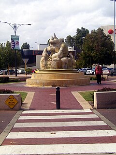
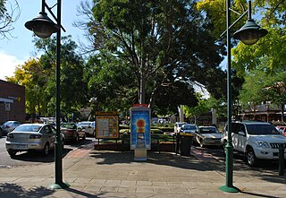
Morley is a suburb of Perth, within the City of Bayswater local government area, situated approximately 10 kilometres (6 mi) northeast of the Perth central business district. It contains the Galleria Shopping Centre, one of Perth's larger shopping centres. Morley bus station is located in the car park of the shopping centre. From the late 1950s, Morley began to develop as a major shopping and commercial centre.
Highton is a residential suburb of Geelong, Victoria, Australia. With views across Geelong, Corio Bay and the surrounding region, Highton is located along the banks of the Barwon River and across the rolling Barrabool Hills. The Barwon River straddles Highton to the north and east, while it is bordered by the hilly Ceres and Wandana Heights to the west, the former Kardinia Creek separates the suburb from Belmont to the south-east, and the Princes Highway and Pigdons Road to the south separate the suburb from Waurn Ponds.

Greenwood is a suburb of Perth, Western Australia, located in the City of Joondalup. The suburb is located 18 km from Perth's central business district. It is bordered by the Mitchell Freeway, Hepburn ave, Wanneroo road and Warwick road.

Joondalup is a suburb of Perth, Western Australia, approximately 26 kilometres (16 mi) north of Perth's central business district. It contains the central business district of the regional City of Joondalup and acts as the primary urban centre of Perth's outer northern suburbs.

The Division of Perth is an Australian electoral division in the state of Western Australia. It is named after Perth, the capital city of Western Australia, where the Division is located.
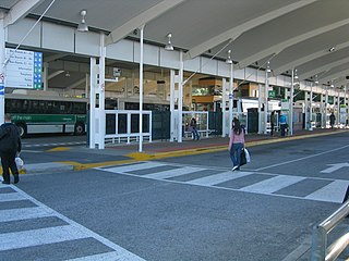
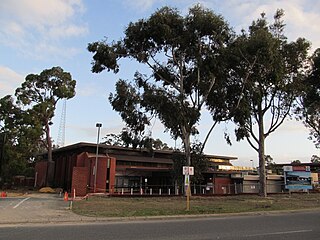
Morley bus station is a Transperth bus station located next to the Galleria Shopping Centre in Morley, Western Australia. It has 12 stands and is served by 20 Transperth routes operated by Path Transit, Swan Transit and Transdev WA.

Bedford is a suburb 6 kilometres (4 mi) north-east of the central business district (CBD) of Perth, the capital of Western Australia. Named after Frederick Bedford, the Governor of Western Australia from 1903 to 1909, the suburb is within the City of Bayswater local government area. It is predominantly a low density residential suburb consisting of single-family detached homes, with clusters of commercial buildings along Beaufort Street, Grand Promenade and Walter Road.
Embleton is a suburb of Perth, the capital city of Western Australia, located 7 kilometres (4.3 mi) north-east of the central business district, between the suburbs of Morley and Bayswater. Its local government area is the City of Bayswater.
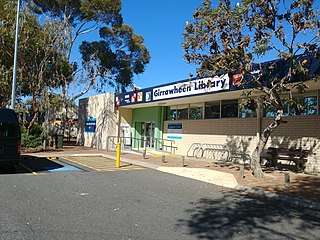
Girrawheen is a northern suburb of Perth, the capital city of Western Australia. Its local government area is the City of Wanneroo.
Landsdale is a northern suburb of Perth, Western Australia located within the local government area of the City of Wanneroo. It is mixed use, with residential, commercial and light manufacturing areas.
Warwick is a suburb of Perth, Western Australia, within the City of Joondalup. Its postcode is 6024. The eastern third of the suburb is a native bushland area known as the Warwick Open Space.
High Wycombe is a suburb of Perth, Western Australia, within the City of Kalamunda. High Wycombe lies east of the Perth CBD at the base of the Darling Scarp. Formerly part of Maida Vale, the suburb was officially declared on 2 June 1978; its name, which was first used in 1958 by a subdivider, Western Agencies, and refers to the town in Buckinghamshire where one of the partners in the firm was born.

Bayswater is a suburb 6 km (4 mi) north-east of the central business district (CBD) of Perth, the capital of Western Australia. It is just north of the Swan River, within the City of Bayswater local government area. It is predominantly a low-density residential suburb consisting of single-family detached homes. However, there are several clusters of commercial buildings, most notably in the suburb's town centre, around the intersection of Whatley Crescent and King William Street and a light industrial area in the suburb's east.
The Morley–Ellenbrook line is a planned suburban rail service between the Perth central business district and Ellenbrook in Western Australia. Construction began in 2021 as part of Metronet.
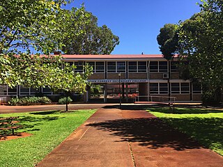
John Forrest Secondary College is an Independent Public secondary school in the Perth suburb of Morley, Western Australia.


