Dianella is a suburb of Perth, Western Australia. It is within the local government area of the City of Stirling.

Bassendean is a north-eastern suburb of Perth, Western Australia. Its local government area is the Town of Bassendean.

Yangebup is a southern suburb of Perth, Western Australia in the City of Cockburn. It takes its name from the nearby Yangebup Lake.

Kensington is a residential suburb 3 km from Perth's central business district. Kensington is located within the City of South Perth and Town of Victoria Park local government areas.

Bassendean railway station is a Transperth station located in Bassendean, 10.8 kilometres (6.7 mi) north-east of Perth railway station, on the Midland Line.
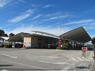
Morley bus station is a Transperth bus station located next to the Galleria Shopping Centre in Morley, Western Australia. It has 12 stands and is served by 20 Transperth routes operated by Path Transit, Swan Transit and Transdev WA.

Ardross is a suburb of Perth, Western Australia, located within the City of Melville. It was once an area of land acquired by the Scotsman, Sir Alexander Percival Matheson in 1896. In Matheson's subdivision of the adjoining suburb of Applecross, he created "Ardross Street" naming it after either the town of Ardrossan on the Scottish west coast or Ardross Castle, located about 40 kilometres north of Inverness. The suburb derives its name from this street.

Alexander Heights is a suburb of Perth, Western Australia within the City of Wanneroo.
Ashfield is a residential suburb of Perth, Western Australia in the Town of Bassendean. The suburb is located along the Swan River. The Midland line passes through the suburb and it is serviced by the Ashfield railway station.

Alfred Cove is a southern suburb of Perth, Western Australia. Its local government area is the City of Melville.

Canning Vale is a southern suburb of Perth, 22 km (13.7 mi) from the central business district. Its local government areas are the City of Canning and the City of Gosnells.
Embleton is a suburb of Perth, the capital city of Western Australia, located 7 kilometres (4.3 mi) north-east of the central business district, between the suburbs of Morley and Bayswater. Its local government area is the City of Bayswater.

Bentley is a southern suburb of Perth, the capital city of Western Australia, 8 kilometres (5.0 mi) southeast of Perth's central business district. Its local government areas are the City of Canning and the Town of Victoria Park. Bentley is home to the main campus of Curtin University and Technology Park.
St James is a suburb shared between the Town of Victoria Park and the City of Canning in the Perth metropolitan area.

North Perth is a suburb of Perth, Western Australia, located within the City of Vincent.

Ellenbrook is a northeastern suburb of Perth, Western Australia, about 30 km (19 mi) from Perth's central business district (CBD), located within the City of Swan. Ellenbrook, and its neighbouring suburbs of The Vines and Aveley, are unusual for Perth in being a significant distance from neighbouring suburbs. Given this relative isolation and the distance from the CBD, Ellenbrook has been designed and developed as a self-sustainable community. Since the upgrade of Gnangara Road and the completion of the Tonkin Highway Northlink, access to Ellenbrook has improved. The Morley–Ellenbrook railway line is well underway as at June 2021 and this will enable better public transport. At the time of the 2016 census there were 22,681 people living in the gazetted suburb, by June 2018, it was estimated that the urban population for Ellenbrook and surrounds had grown to 41,382. It is envisioned that Ellenbrook will eventually become a satellite city, with a population of 80,000.

Belmont is a suburb of Perth, the capital city of Western Australia, and is located 7 kilometres (4 mi) east of Perth's central business district (CBD) on the southern bank of the Swan River. Its local government area is the City of Belmont.

Nedlands is a western suburb of Perth, the capital city of Western Australia. It is a part of the local government areas of the City of Nedlands and the City of Perth. It is about 7 kilometres (4 mi) from the Perth CBD via either Thomas Street or Mounts Bay Road.

Whiteman, Western Australia is a suburb in the north eastern part of the Perth, metropolitan area in Western Australia.
