
The Swan River is a major river in the southwest of Western Australia. The river runs through the metropolitan area of Perth, Western Australia's capital and largest city.

North Beach is a northern coastal suburb of Perth, the capital city of Western Australia 16 kilometres (10 mi) from Perth's central business district via Mitchell Freeway and Reid Highway. Its local government area is the City of Stirling.

Eyre Highway is a 1,664-kilometre (1,034 mi) highway linking Western Australia and South Australia via the Nullarbor Plain. Signed as National Highways 1 and A1, it forms part of Highway 1 and the Australian National Highway network linking Perth and Adelaide. It was named after explorer Edward John Eyre, who was the first European to cross the Nullarbor by land, in 1840–1841. Eyre Highway runs from Norseman in Western Australia, past Eucla, to the state border. Continuing to the South Australian town of Ceduna, it crosses the top of the Eyre Peninsula before reaching Port Augusta.

Applecross is an affluent riverside suburb of Perth, Western Australia, bounded by Canning Highway and the Swan River. It is located within the City of Melville.

Swan View is an eastern suburb of Perth, Western Australia. Its local government areas are the City of Swan and the Shire of Mundaring. It is 25 kilometres (16 mi) from Perth in the Perth Hills on the edge of the Darling Scarp, just to the west of the John Forrest National Park, east of Roe Highway and north of the Great Eastern Highway.
Harold Emanuel Freedman O.A.M. was an artist from Victoria, Australia, renowned as an illustrator and lithographer, as an official war artist, and for his work in public murals.

Mahogany Creek is a suburb of Perth, the state capital of Western Australia. It is part of the Shire of Mundaring local government area.

Thebarton, formerly Theberton, on Kaurna land, is an inner-western suburb of Adelaide, South Australia in the City of West Torrens. The suburb is bounded by the River Torrens to the north, Port Road and Bonython Park to the east, Kintore Street to the south, and South Road to the west.
West Footscray is an inner-city suburb in Melbourne, Victoria, Australia, 7 km (4.3 mi) west of Melbourne's Central Business District, located within the City of Maribyrnong local government area. West Footscray recorded a population of 11,729 at the 2021 census.

Baskerville is an outer northeastern rural suburb of Perth, Western Australia, in the Swan Valley region, 31 km from Perth's central business district via Midland and Great Northern Highway. Nearly all of it is under cultivation with viticulture being the main economic activity, and several well-established Swan Valley wineries are based here. Its local government area is the City of Swan.
West Swan is a suburb of Perth, Western Australia, located in the City of Swan local government area. It lies west of the Swan River, and east of the former Caversham Motor Racing Circuit. The suburb is traversed by the West Swan Road, one of the main routes in the Swan Valley winery area. At the 2016 Australian census the suburb had a population of 899.

Hindmarsh is an inner suburb of Adelaide, South Australia. It is located in the City of Charles Sturt.

In 1929, Western Australia (WA) celebrated the centenary of the founding of Perth and the establishment of the Swan River Colony, the first permanent European settlement in WA. A variety of events were run in Perth, regional areas throughout the state, and even across Australia such as the Western Australian Centenary Air Race.
Thomas Arthur Guy Hungerford, AM was an Australian writer, noted for his World War II novel The Ridge and the River, and his short stories that chronicle growing up in South Perth, Western Australia during the Great Depression.
Mooliabeenee is a locality in Western Australia, east of Gingin, within the Shire of Chittering.

Riverside Drive in Perth, Western Australia, is a road on the northern side of Perth Water. It was built on reclaimed land in the 1930s, and links The Causeway to the Narrows Bridge.

Princess Royal Harbour is a part of King George Sound on the South coast of Western Australia, and harbour to Albany. On its northern shore is the Port of Albany. The name Princess Royal also appears in Albany in Princess Royal Fortress and Princess Royal Drive.
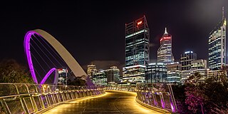
Tourism in Perth, the capital city of Western Australia, is an important part of the Australian state's economy, contributing to the prosperity of businesses in the city, as well as other regions of the state.

Midland is a suburb and historic town of Perth, Western Australia, located 15 km (9.3 mi) northeast of Perth's central business district. It is the administrative seat and commercial centre of the City of Swan local government area. It is also a designated strategic metropolitan centre for the larger Perth metropolitan area.

Wunderlich were a brand of decorative metal panels used for pressed metal ceilings and other architectural elements in Australia.

