
The City of Swan is a local government area of Western Australia. It is in the eastern metropolitan region of Perth and includes the Swan Valley and 42 suburbs. It is centred approximately 20 km north-east of the Perth central business district. The City covers an area of 1,042 km² and had an estimated population of 155,653 in 2020.
Ballajura is a suburb of Perth, Western Australia, in the City of Swan local government area. Ballajura is located 14 km north of the Perth CBD. The postcode for the suburb is 6066.

Cookernup is a town in the South West of Western Australia near the South Western Highway, between Waroona and Harvey.
Brentwood is a suburb of Perth, Western Australia, located within the City of Melville and approximately 10 km from Perth city centre. The nearest airport is Perth Airport and the nearest railway station is Bull Creek.

City Beach is a beachside suburb of Perth, Western Australia, located within the Town of Cambridge. Its postcode is 6015. It is also the name of a beach in the suburb. House prices are generally quite expensive. In 2020, City Beach had the fifth highest median house price in Perth, at $1.628 million.
Wembley is a western suburb of Perth, Western Australia, located within the Town of Cambridge. Its postcode is 6014.
Gnangara is a suburb of Perth, Western Australia, located within the City of Wanneroo. Gnangara is also the name for an underground water mound with a 117-hectare surface feature called Lake Gnangara.

Mandogalup is a suburb of Perth, Western Australia, located within the City of Kwinana. Its postcode is 6167.

North Fremantle is a suburb of Perth, Western Australia, located within the City of Fremantle, a local government area of the state. Its postcode is 6159.
Langford is a suburb of Perth, Western Australia, located within the City of Gosnells. Its postcode is 6147.
Warwick is a suburb of Perth, Western Australia, within the City of Joondalup. Its postcode is 6024. The eastern third of the suburb is a native bushland area known as the Warwick Open Space.
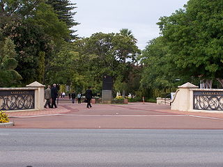
Karrakatta is a suburb of Perth, Western Australia, located within the City of Nedlands and 7 km west of the central business district. Its postcode is 6010.

Shenton Park is a suburb of Perth, Western Australia, located within the City of Nedlands and City of Subiaco and 4 km (2.5 mi) west of the central business district. Its postcode is 6008. The suburb is named after the park that it contains, Shenton Park, which was named after George Shenton who originally owned the land that is now the suburb of Shenton Park.

Midvale is a suburb of Perth, Western Australia, which is split between the City of Swan and the Shire of Mundaring. Its postcode is 6056.
Muchea is a town in the Shire of Chittering, located 43 km (27 mi) north north-east of Perth. Its postcode is 6501. The town's name comes from the Aboriginal word "Muchela" which means in Nyoongar 'water hole', referring to the abundance of water in Muchea.
Melaleuca is a suburb of Perth, Western Australia, located in the City of Swan local government area.

Beaufort Street is a major road in the inner north-eastern suburbs of Perth, Western Australia, connecting the Morley area to the Perth central business district. For most of its length, it is a single-carriageway, two-way road with two lanes in each direction.
Israelite Bay is a bay and locality on the south coast of Western Australia – frequently mentioned in Bureau of Meteorology weather reports as a geographical marker although it does not have a climate record.

Postcodes in Australia are used to more efficiently sort and route mail within the Australian postal system. Postcodes in Australia have four digits and are placed at the end of the Australian address, before the country. Postcodes were introduced in Australia in 1967 by the Postmaster-General's Department and are now managed by Australia Post, Australia's national postal service. Postcodes are published in booklets available from post offices or online from the Australia Post website.
Barbalin is a town situated in the Shire of Mukinbudin in Western Australia.
