
The Swan River is a major river in the southwest of Western Australia. The river runs through the metropolitan area of Perth, Western Australia's capital and largest city.

The City of Bayswater is a local government area in the Western Australian capital city of Perth, about 7 kilometres (4 mi) northeast of Perth's central business district. The city covers an area of 34.6 square kilometres (13.4 sq mi) and had a population of 69,283 as at the 2021 Census. The City of Bayswater is a member of the Eastern Metropolitan Regional Council.

The City of Swan is a local government area of Western Australia. It is in the eastern metropolitan region of Perth and includes the Swan Valley and 42 suburbs. It is centred approximately 20 km north-east of the Perth central business district. The City covers an area of 1,042 km2 and had an estimated population of 155,653 in 2020.
Spencers Brook is a waterway, locality and a district located within the Avon Valley in Western Australia.

Great Eastern Highway is a 590-kilometre-long (370 mi) road that links the Western Australian capital of Perth with the city of Kalgoorlie. A key route for road vehicles accessing the eastern Wheatbelt and the Goldfields, it is the western portion of the main road link between Perth and the eastern states of Australia. The highway forms the majority of National Highway 94, although the alignment through the Perth suburbs of Guildford and Midland, and the eastern section between Coolgardie and Kalgoorlie are not included. Various segments form parts of other road routes, including National Route 1, Alternative National Route 94, and State Route 51.

Ballajura is a suburb of Perth, Western Australia, in the City of Swan local government area. Ballajura is located 14 kilometres (8.7 mi) north of the Perth central business district. Situated on its side of its western boundary with Koondoola is Emu Swamp.
Embleton is a suburb of Perth, the capital city of Western Australia, located 7 kilometres (4.3 mi) north-east of the central business district, between the suburbs of Morley and Bayswater. Its local government area is the City of Bayswater.

Alkimos is a coastal suburb of Perth, Western Australia, located 42 kilometres (26 mi) north-northwest of Perth's central business district. It is part of the City of Wanneroo local government area.

Eglinton is a locality in the Western Australian capital city of Perth, approximately 44 kilometres (27 mi) north of Perth's central business district on the Indian Ocean. For the most part, the suburb is covered in native banksia woodland, scrubland and heath typical of the Swan Coastal Plain. However, in recent years, there has been growth in residential estates, with a town centre to be built in the near future.

Jindalee is an outer coastal suburb of Perth, Western Australia, located approximately 40 kilometres (25 mi) north of the Perth central business district. Its local government area is the City of Wanneroo.

Leda is a southern suburb of Perth, Western Australia within the City of Kwinana. Leda is one of the five main suburbs of Kwinana.

Swan View is an eastern suburb of Perth, Western Australia. Its local government areas are the City of Swan and the Shire of Mundaring. It is 25 kilometres (16 mi) from Perth in the Perth Hills on the edge of the Darling Scarp, just to the west of the John Forrest National Park, east of Roe Highway and north of the Great Eastern Highway.

Ellenbrook is a northeastern suburb of Perth, Western Australia, about 30 km (19 mi) from Perth's central business district (CBD), located within the City of Swan. Ellenbrook, and its neighbouring suburbs of The Vines and Aveley, are unusual for Perth in being a significant distance from neighbouring suburbs. Given this relative isolation and the distance from the CBD, Ellenbrook has been designed and developed as a self-sustainable community. Since the upgrade of Gnangara Road and the completion of the Tonkin Highway Northlink, access to Ellenbrook has improved. The Morley–Ellenbrook railway line is well underway as at June 2021 and this will enable better public transport. At the time of the 2016 census there were 22,681 people living in the gazetted suburb, by June 2018, it was estimated that the urban population for Ellenbrook and surrounds had grown to 41,382. It is envisioned that Ellenbrook will eventually become a satellite city, with a population of 80,000.

The City of Perth is a local government area and body, within the Perth metropolitan area, which is the capital of Western Australia. The local government is commonly known as Perth City Council. The City covers the Perth city centre and surrounding suburbs. The City covers an area of 20.01 square kilometres (8 sq mi) and had an estimated population of 21,092 as at 30 June 2015. On 1 July 2016 the City expanded, absorbing 1,247 residents from the City of Subiaco.

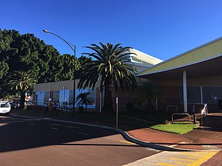
Bayswater is a suburb 6 kilometres (4 mi) north-east of the central business district (CBD) of Perth, the capital of Western Australia. It is just north of the Swan River, within the City of Bayswater local government area. It is predominantly a low-density residential suburb consisting of single-family detached homes. However, there are several clusters of commercial buildings, most notably in the suburb's town centre, around the intersection of Whatley Crescent and King William Street and a light industrial area in the suburb's east.

Cullacabardee is a northeastern rural suburb of Perth, the capital city of Western Australia, located 21 km (13 mi) from Perth's central business district via Alexander Drive or Beechboro Road. It is in the City of Swan local government area. Most of the suburb is covered in native sheoak and banksia forest. A small Noongar community is based on Baal Street, a drug rehabilitation retreat is located off Gnangara Road in the suburb's northeast, and the Perth International Telecommunications Centre facility is based in the suburb's northwest.
Punyelroo is a town located on the Murray River in South Australia, Australia, approximately 5 kilometres downstream from Swan Reach, but on the opposite side of riverbank. The town is named after a local homestead. It accessible by sealed bitumen road most conveniently off the Sedan Swan Reach Road or by a well made dirt road from Mannum.

Ellen Brook is an ephemeral stream which runs from south of Gingin to the Swan River in Western Australia.

Bennett Brook is a stream that runs from Whiteman Park to the Swan River in Western Australia.
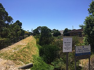
Bayswater Brook was a natural brook in the north-eastern suburbs of Perth, Western Australia, which discharges into the Swan River in the suburb of Bayswater. In the 1920s, due to urban development, the brook was turned into a network of drainage channels, which are partially covered and partially open. The brook's water source is runoff and groundwater. In the 1970s, the Eric Singleton Bird Sanctuary was built near the mouth of the brook. Water from the Bayswater Brook flows through the wetlands at the bird sanctuary before continuing to the Swan River. It has an average annual flow of 7.5 gigalitres.
