Gnangara, Western Australia

Last updated

Gnangara
Perth,  Western Australia
Gnangara, Western Australia
Coordinates 31°46′23″S115°51′40″E / 31.773°S 115.861°E / -31.773; 115.861
Population1,347 (SAL 2021) [1]
Postcode(s) 6077
Area14 km2 (5.4 sq mi)
Location
LGA(s) City of Wanneroo
State electorate(s) Wanneroo
Federal division(s) Pearce
Suburbs around Gnangara:
Wanneroo Jandabup Melaleuca
Wanneroo Gnangara Lexia
Wangara Landsdale Cullacabardee

Gnangara is a suburb of Perth, Western Australia, located within the City of Wanneroo. Gnangara is also the name for an underground water mound with a 117-hectare surface feature called Lake Gnangara. The suburb is named after the lake, whose name is derived from the Aboriginal word Knangara. [2]

Contents

Facilities

Much of the suburb's area is semi rural, with residential estate developed in the early 1990s by Midland Brick and centred on Lakelands Drive borders includes the private 18-hole golf course Lakelands Country Club, established in 1984 on 70 hectares. [3] The Perth International Telecommunications Centre is located near and often associated with Gnangara.

Location

Gnangara is bounded by Ocean Reef Road and Gnangara Road to the south, Badgerup Road and Ross Road to the west and the Gnangara Pine Plantation to the northeast and east. While the plantation is named for the suburb, only a few hectares of it are within the suburb's boundaries, with the majority in Lexia to the east. [4]

Education

Gnangara contained the Aboriginal Community College (K-12), founded in 1979 and closed in 2008. It was one of two independent Indigenous schools in the metropolitan area. [5]

Transport

Bus

Related Research Articles

Balga is a suburb of Perth, the capital city of Western Australia, 13 kilometres (8 mi) north of Perth city's central business district (CBD). Its local government area is the City of Stirling. Mark Irwin is the current mayor.

<span class="mw-page-title-main">Mirrabooka, Western Australia</span> Suburb of Perth, Western Australia

Mirrabooka is a suburb of Perth, Western Australia. Its local government area is the City of Stirling. At the 2021 census it had a population of 8,000 people.

<span class="mw-page-title-main">Westminster, Western Australia</span> Suburb of Perth, Western Australia

Westminster is a suburb approximately 12 kilometres north of Perth, Western Australia. Its local government area is the City of Stirling.

<span class="mw-page-title-main">Yangebup, Western Australia</span> Suburb of Perth, Western Australia

Yangebup is a southern suburb of Perth, Western Australia in the City of Cockburn. It takes its name from the nearby Yangebup Lake.

<span class="mw-page-title-main">Marangaroo, Western Australia</span> Suburb of Perth, Western Australia

Marangaroo is a suburb of Perth, Western Australia. It is located approximately 18 km north of Perth City, within the City of Wanneroo. Marangaroo's borders comprise Wanneroo Road, Hepburn Avenue, Mirrabooka Avenue and Marangaroo Drive.

<span class="mw-page-title-main">Currambine, Western Australia</span> Suburb of Perth, Western Australia

Currambine is a northern suburb of Perth, the capital city of Western Australia, 29 km north of Perth's central business district. Its local government area is the City of Joondalup.

<span class="mw-page-title-main">Coolbellup, Western Australia</span> Suburb of Perth, Western Australia

Coolbellup is a suburb in Perth, Western Australia, located 15 kilometres (9.3 mi) south of the central business district within the local government area of the City of Cockburn.

<span class="mw-page-title-main">Karawara, Western Australia</span> Suburb of Perth, Western Australia

Karawara is a suburb of Perth, Western Australia. In 2016 census, the total population was at 2,061.

<span class="mw-page-title-main">Alexander Heights, Western Australia</span> Suburb of Perth, Western Australia

Alexander Heights is a suburb of Perth, Western Australia within the City of Wanneroo.

Ashby is a suburb of Perth, the capital city of Western Australia 26 kilometres (16 mi) north of Perth's central business district. Its local government area is the City of Wanneroo.

<span class="mw-page-title-main">Girrawheen, Western Australia</span> Suburb of Perth, Western Australia

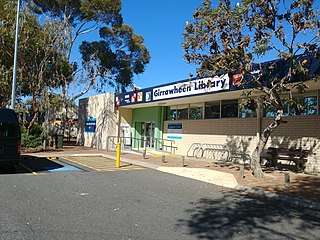
Girrawheen is a northern suburb of Perth, the capital city of Western Australia. Its local government area is the City of Wanneroo.

Landsdale is a northern suburb of Perth, Western Australia located within the local government area of the City of Wanneroo. It is mixed use, with residential, commercial and light manufacturing areas.

<span class="mw-page-title-main">Neerabup, Western Australia</span> Suburb of Perth, Western Australia

Neerabup is a rural locality in Perth, the capital of Western Australia, within the local government area of the City of Wanneroo.

<span class="mw-page-title-main">Wangara, Western Australia</span> Suburb of Perth, Western Australia

Wangara is a light industrial suburb of Perth, Western Australia, located within the City of Wanneroo.

<span class="mw-page-title-main">Beaconsfield, Western Australia</span> Suburb of Perth, Western Australia

Beaconsfield is a suburb of Perth, Western Australia, located within the City of Fremantle. It was named after a property of the same name in the area in the 1880s; the name was officially adopted from the post office on 1 August 1894. The name's origin is unknown, but it probably comes from the town in England or the Earl of Beaconsfield, Benjamin Disraeli, a former Conservative Prime Minister of the United Kingdom.

<span class="mw-page-title-main">Mullaloo, Western Australia</span> Suburb of Perth, Western Australia

Mullaloo is a northern coastal suburb of Perth, Western Australia, within the City of Joondalup.

<span class="mw-page-title-main">Ellenbrook, Western Australia</span> Suburb of Perth, Western Australia

Ellenbrook is a northeastern suburb of Perth, Western Australia, about 30 km (19 mi) from Perth's central business district (CBD), located within the City of Swan. Ellenbrook, and its neighbouring suburbs of The Vines and Aveley, are unusual for Perth in being a significant distance from neighbouring suburbs. Given this relative isolation and the distance from the CBD, Ellenbrook has been designed and developed as a self-sustainable community. Since the upgrade of Gnangara Road and the completion of the Tonkin Highway Northlink, access to Ellenbrook has improved. The Morley–Ellenbrook railway line is well underway as at June 2021 and this will enable better public transport. At the time of the 2016 census there were 22,681 people living in the gazetted suburb, by June 2018, it was estimated that the urban population for Ellenbrook and surrounds had grown to 41,382. It is envisioned that Ellenbrook will eventually become a satellite city, with a population of 80,000.

<span class="mw-page-title-main">Henley Brook, Western Australia</span> Suburb of Perth, Western Australia

Henley Brook is an outer rural suburb of Perth, Western Australia, part of the Swan Valley wine region. The Ellen brook and Swan River meet in the northeastern corner of the suburb. This is also the farthest upstream Captain Stirling's 1827 exploration reached before deciding on the settlement site of the new colony in 1829. The All Saints Church, the oldest church in Western Australia, is also at this site.

<span class="mw-page-title-main">Stirling, Western Australia</span> Suburb of Perth, Western Australia

Stirling is a suburb of Perth, the capital city of Western Australia, about 10 km north of Perth's central business district (CBD) along the Mitchell Freeway. Its local government area is the City of Stirling, whose council offices and administration centre are located in the southwest of the mostly residential suburb.

Aveley is a suburb of Perth, Western Australia, east of Ellenbrook and south of The Vines. In 1897 George Hardey Barrett Lennard, grandson of Edward Pomeroy Barrett-Lennard, purchased a property in the area of which is now Aveley, naming it "Belhus" after his family's estate in Belhus, Essex, England. The name "Aveley", deriving from the eponymous town where the estate was located, was approved as a suburb name on 6 September 2006, before which the area was part of Ellenbrook. It is bordered by Gnangara Road and Lake Yakine to the south, a small part of West Swan Road, the Ellen Brook and Chateau Place to the east, The Broadway, Doig Road, and Cashman Avenue to the north, and Henley Brook Avenue to the west. The suburb is accessible from Henley Brook Avenue, The Promenade, Gnangara Road, and West Swan Road.

References

  1. Australian Bureau of Statistics (28 June 2022). "Gnangara (suburb and locality)". Australian Census 2021 QuickStats. Retrieved 28 June 2022.  OOjs UI icon edit-ltr-progressive.svg
  2. "History of metropolitan suburb names – G". Western Australian Land Information Authority. Archived from the original on 16 March 2022. Retrieved 16 July 2024.
  3. Lakelands Country Club home page
  4. Department of Land Information. StreetSmart Perth Street Directory (54th ed.). West Australian Newspapers Ltd. pp. Maps 252-253. ISBN   978-0-909439-67-5.
  5. Association of Independent Schools (AICS Support Unit). "Aboriginal Community College". Archived from the original on 12 September 2009. Retrieved 13 September 2009.
  6. "Route 355". Bus Timetable 98 (PDF). Transperth. 26 April 2023 [effective from 12 June 2023].
  7. "Route 376". Bus Timetable 75 (PDF). Transperth. 13 November 2023 [effective from 17 December 2023].