
Hamersley is a residential suburb 14 kilometres north-northwest of the central business district of Perth, the capital of Western Australia, and six kilometres (4 mi) from the Indian Ocean. The suburb adjoins two major arterial roads—Mitchell Freeway to the west and Reid Highway to the south—and is within the City of Stirling local government area. It was built during the late 1960s and 1970s as part of the Government of Western Australia's response to rapidly increasing land prices across the metropolitan area.

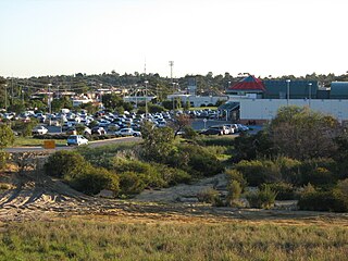
Osborne Park is a suburb of Perth, Western Australia in the local government area of the City of Stirling and City of Vincent.

The City of Wanneroo is a local government area with city status in the northern suburbs of Perth, Western Australia. It is centred approximately 25 kilometres (15.5 mi) north of Perth's central business district and forms part of the northern boundary of the Perth metropolitan area. Wanneroo encompasses the federal divisions of Cowan, Moore and Pearce.

Nowergup is a rural locality about 40 kilometres (25 mi) north of Perth, Western Australia. It is in the local government area of the City of Wanneroo.

Dowerin is a town 156 kilometres (97 mi) north-east of Perth in the central Wheatbelt region of Western Australia. It is the seat of the Shire of Dowerin.

Yanchep is an outer coastal suburb of Perth, Western Australia, 56 kilometres (35 mi) north of the Perth CBD. It is a part of the City of Wanneroo local government area. Originally a small crayfishing settlement, it was developed by entrepreneur Alan Bond in the 1970s and 80s for the 1987 America's Cup. The area covers the urban centre of Yanchep as well as Yanchep National Park in its entirety.
Ashby is a suburb of Perth, the capital city of Western Australia 26 kilometres (16 mi) north of Perth's central business district. Its local government area is the City of Wanneroo.

Banksia Grove is a suburb of Perth, Western Australia, located within the City of Wanneroo. Its postcode is 6031, and it was until the late 1990s part of Neerabup. The suburb is approximately 27 km NE of the Perth central business district, 8 km east of the coast and 5 km ENE of Joondalup.

Carabooda is a rural locality in outer northern Perth, Western Australia. Its local government area is the City of Wanneroo.
Carramar is a suburb of Perth, Western Australia, located within the City of Wanneroo and it is situated 30 km from the Perth CBD. Its postcode is 6031, and it came into being, together with Tapping to the south, in 1995 as a subdivision of Neerabup.

Hocking is a suburb of Perth, Western Australia, located within the City of Wanneroo. Until 1994 it was part of the suburb of Wanneroo. The suburb was named after Herbert Hocking, a local landowner, first chairman of the Wanneroo Road Board and member of the Board from 1903 to 1931. He was also treasurer of the Agricultural Society in 1909.
Madeley is a suburb of Perth, the capital city of Western Australia 20 kilometres (12 mi) north of Perth's central business district. Its local government area is the City of Wanneroo. Previously part of Landsdale, much of the suburb was rural in character until the 1990s, with market gardening a common activity. From 2001 onwards, extensive property development resulted in massive population growth, with the Property Investor Magazine of December 2007 estimating a growth rate of 33.3% per year.

Neerabup is a rural locality in Perth, the capital of Western Australia, within the local government area of the City of Wanneroo.
Tapping is a suburb of Perth, Western Australia, located within the City of Wanneroo. It came into being in the early 1990s as a subdivision of Wanneroo, originally as part of the Carramar estate.

Kwinana Beach is an outer southwestern suburb of Perth, Western Australia, located within the City of Kwinana. It is one of the traditional industrial suburbs in the Perth metropolitan region.
The City of Joondalup is a local government area in Perth, Western Australia. Its central business district is located in the suburb Joondalup, and it includes the town centres of Hillarys and Warwick.
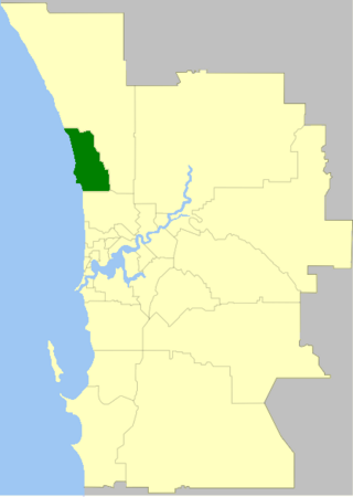
Mindarie was an electoral district of the Legislative Assembly in the Australian state of Western Australia. The district was named for the outer northern Perth suburb of Mindarie, which falls within its borders.
Perth Motorplex is a motorsport venue located at Kwinana Beach, Western Australia. It caters mainly for drag racing and speedway, although other events are held there regularly. Over 275,000 patrons attend the venue each year to many varied events. The Perth Motorplex holds rounds of the World Series Sprintcars championship.

Virginia is a suburb on the rural outskirts of Adelaide, the capital city of South Australia. Port Wakefield Road, the main highway taking traffic to the north of Adelaide, passes through the area and used to pass straight through Virginia. Market gardening is the main activity there.

The Claremont Speedway was a racing circuit in the grounds of the Claremont Showground in the suburb of Claremont in Western Australia's capital city of Perth. The speedway held its first meeting on 14 May 1927, and its final meeting on 31 March 2000.

