Pinjar Road

Last updated

Pinjar Road

Pinjar Road
General information
TypeRoad
Length6.7 km (4.2 mi) [1]
Former
route number
Australian state route 86.svg State Route 86
Tourist routesAustralian Tourist Drive 359.svg Tourist Drive 359
Major junctions
South endAustralian state route 60.svg Wanneroo Road (State Route 60), Ashby
 Australian state route 85.svg Joondalup Drive (State Route 85)
North endFlynn Drive, Banksia Grove
Location(s)
Major suburbs Sinagra, Tapping, Mariginiup, Carramar

Pinjar Road is a major distributor road in the north-eastern suburbs of Perth, Western Australia, located within the City of Wanneroo.

Contents

The road was formerly part of the now-decommissioned State Route 86, [2] [3] and one of Perth's major arterial roads, previously connecting with Old Yanchep Road in Pinjar. Due to the road's impact as a freight route on adjoining residential properties, it was extensively realigned in 2005, and ultimately downgraded in importance with the extension of Joondalup Drive and State Route 85 a year later.

History

2005 re-alignment

In 2005, the relevant local government body responsible for the road, the City of Wanneroo, realised the importance of the road and the impact it has on the residents in the adjoining suburbs of Banksia Grove, Carramar, Mariginiup, Neerabup and Tapping due to increased traffic. [4] Funding for the realignment was an issue as the responsibility of construction fell to the developers of the adjoining Carramar Golf Course Estate, Peet Limited, and the city's original plans did not call for construction of this road until at least 2008–2009.

In order to expedite construction and relieve traffic pressures, the city agreed to pre-fund construction of the realignment by Peet, enabling the road to be completed and opened midway through 2006. Prior to the opening of this realignment however, the extension of Joondalup Drive from Wanneroo Road to Neaves Road was also completed and opened to traffic. This in turn caused a large number of heavy westbound vehicles to deviate through local roads within Banksia Grove to connect with Joondalup Drive.

As a consequence of this, the City implemented an order to limit the types of vehicles allowed to pass through the suburb [5] and imposed on-the-spot penalties of up to $5,000 for offenders. The need for this order was removed when the City subsequently closed the old alignment of Pinjar Road south of the Joondalup Drive/Neaves Road intersection, and north of the Yandella Promenade (formerly Clarkson Avenue)/Pinjar Road intersection.

Division of old road

After the opening of the new Pinjar Road alignment in 2005, the old Pinjar Road was closed and divided into four distinct parts, completely ending its use as an arterial and distributor road for traffic:

The new Pinjar Road follows the old Pinjar Road route from Wanneroo Road, up until Yandella Promenade, where it deviates from the original junction at Neaves Road, to a large roundabout at Joondalup Drive 2 km further south-west. The road now completely bypasses Banksia Grove and forms a suburb boundary between Banksia Grove and Tapping.

Southern realignment

An $8 million project to realign and reconstruct Pinjar Road between Wanneroo Road to Galileo Avenue was undertaken by the City of Wanneroo. The project began in April 2010, with part of the new road opened to traffic in December 2010. Works were scheduled to be completed by December 2011. [6] [ needs update ] The works included shifting the southern terminus with Wanneroo road north-east by approximately 260 metres (850 ft). [7]

Route description

The road travels generally north from Wanneroo Road, servicing the following suburbs:

Only the intersection with Wanneroo Road is controlled by Traffic lights. Traffic flow is maintained by the use of roundabouts and Give Way signs at junctions along the route.

Major intersections

Extension to Flynn Drive

On 9 October 2018, an extension to Pinjar Road was completed and opened to the public, which saw the road connect to Flynn Drive instead of its existing termination point at Joondalup Drive.

This provides direct access to Flynn Drive for residents in Banksia Grove, making it quicker to access the Mitchell Freeway via Neerabup Road instead of Burns Beach Road. Clarkson train station on the Joondalup line also became the closest station for residents instead of Currambine station.

See also

Australia road sign W5-29.svg   Australian Roadsportal

Related Research Articles

<span class="mw-page-title-main">City of Wanneroo</span> Local government area in Western Australia

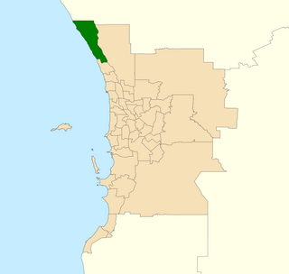
The City of Wanneroo is a local government area with city status in the northern suburbs of Perth, Western Australia. It is centred approximately 25 kilometres (15.5 mi) north of Perth's central business district and forms part of the northern boundary of the Perth metropolitan area. Wanneroo encompasses the federal divisions of Cowan, Moore and Pearce.

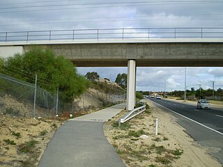
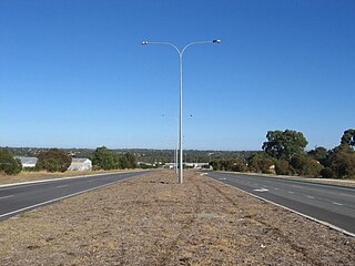
The Mitchell Freeway is a 41.5-kilometre-long (25.8 mi) freeway in the northern suburbs of Perth, Western Australia, linking central Perth with the city of Joondalup. It is the northern section of State Route 2, which continues south as Kwinana Freeway and Forrest Highway. Along its length are interchanges with several major roads, including the Graham Farmer Freeway and Reid Highway. The southern terminus of the Mitchell Freeway is at the Narrows Bridge, which crosses the Swan River, and the northern terminus is at Romeo Road in Alkimos.

<span class="mw-page-title-main">Division of Pearce</span> Australian federal electoral division

The Division of Pearce is an Australian electoral division in the state of Western Australia. It was created at the 1989 redistribution and named after George Pearce, the longest serving member of the Australian Senate, serving from 1901 to 1938. For most of its existence, Pearce was a hybrid urban-rural seat that covered Perth's outer northern suburbs before fanning inland from the Indian Ocean to take in portions of the Wheatbelt southeast, east and northeast of the capital. However, as of the 2021 redistribution, Pearce is largely coterminous with the City of Wanneroo in Perth's northern suburbs. It has had four members: Fred Chaney, Judi Moylan, Christian Porter, and Tracey Roberts. The first three were members of the Liberal Party, whereas Roberts, a former mayor of Wanneroo, is a member of the Labor Party.

<span class="mw-page-title-main">Banksia Grove, Western Australia</span> Suburb of Perth, Western Australia

Banksia Grove is a suburb of Perth, Western Australia, located within the City of Wanneroo. Its postcode is 6031, and it was until the late 1990s part of Neerabup. The suburb is approximately 27 km NE of the Perth central business district, 8 km east of the coast and 5 km ENE of Joondalup.

Carramar is a suburb of Perth, Western Australia, located within the City of Wanneroo and it is situated 30 km from the Perth CBD. Its postcode is 6031, and it came into being, together with Tapping to the south, in 1995 as a subdivision of Neerabup.

<span class="mw-page-title-main">Clarkson, Western Australia</span> Suburb of Perth, Western Australia

Clarkson is an outer northern suburb of Perth, Western Australia, located 34 kilometres north of Perth's central business district in the City of Wanneroo.

<span class="mw-page-title-main">Neerabup, Western Australia</span> Suburb of Perth, Western Australia

Neerabup is a rural locality in Perth, the capital of Western Australia, within the local government area of the City of Wanneroo.

Tapping is a suburb of Perth, Western Australia, located within the City of Wanneroo. It came into being in the early 1990s as a subdivision of Wanneroo, originally as part of the Carramar estate.

<span class="mw-page-title-main">Wanneroo Road</span> Road in Perth, Western Australia

Wanneroo Road is a 44-kilometre (27 mi) arterial highway in the northern suburbs of Perth, Western Australia linking Joondanna and Yokine in the south with Wanneroo and Yanchep in the north. As part of State Route 60, it begins from Charles Street in the inner city and becomes Indian Ocean Drive up to Dongara.

<span class="mw-page-title-main">Marmion Avenue</span> Road in Perth, Western Australia

Marmion Avenue is a 40-kilometre (25 mi) arterial road in the northern coastal suburbs of Perth, Western Australia, linking Trigg in the south with Yanchep in the north. It forms part of State Route 71 along with West Coast Highway, which it joins onto at its southern terminus.

Mindarie was an electoral district of the Legislative Assembly in the Australian state of Western Australia. The district was named for the outer northern Perth suburb of Mindarie, which falls within its borders.

<span class="mw-page-title-main">Electoral district of Wanneroo</span> State electoral district of Perth, Western Australia

Wanneroo is an electoral district of the Legislative Assembly in the Australian state of Western Australia.

Joondalup Drive is a major distributor road in the northern suburbs of Perth, Western Australia. The road travels through the City of Joondalup's central business district and extends for a few kilometres east through neighbouring residential suburbs in the City of Wanneroo. The road was extended in 2005 to the northern suburb of Banksia Grove to provide easy access for residents to Joondalup's city centre, and to provide a complete connecting route to the Brand Highway from the Mitchell Freeway.

<span class="mw-page-title-main">Burns Beach Road</span> Road in Perth, Western Australia

Burns Beach Road is an arterial east-west road in Perth, Western Australia, linking the suburbs of Burns Beach and Iluka to the Mitchell Freeway and Joondalup. It forms the entirety of State Route 87 and was the northern terminus of Mitchell Freeway and State Route 2 from 2008 to 2017, when the freeway was extended to Hester Avenue.

<span class="mw-page-title-main">Ocean Reef Road</span> Road in Perth, Western Australia

Ocean Reef Road is an arterial east-west road in Perth, Western Australia. It is located within the northern suburbs of Perth, from Ocean Reef in the west, to Landsdale in the east, with a portion travelling northwards along the coast to Iluka.

<span class="mw-page-title-main">Connolly Drive</span> Road in Perth, Western Australia

Connolly Drive is an arterial road in the outer northern suburbs of Perth, Western Australia. The road takes its name from the Perth suburb of Connolly, which lies just beyond the road's terminus.

<span class="mw-page-title-main">Hester Avenue</span>

Hester Avenue is an east-west distributor road in the northern suburbs of Perth, Western Australia, located within the City of Wanneroo. It primarily links the coastal suburbs of the Clarkson-Butler region to the arterial highway Wanneroo Road in the east.

<span class="mw-page-title-main">Electoral district of Butler</span>

Butler is a Legislative Assembly electorate in the state of Western Australia. The district is named for the outer northern Perth suburb of Butler, which falls within its borders.

<span class="mw-page-title-main">Joseph Banks Secondary College</span> School in Western Australia

Joseph Banks Secondary College is an independent public co-educational high day school, located in Banksia Grove, a suburb 29 kilometres (18 mi) north of Perth, Western Australia.

The 2023 Wanneroo bushfire was a bushfire that began on 22 November 2023 in Wanneroo, 36 kilometres north of the Perth central business district, in the City of Wanneroo, Western Australia.

References

  1. "Pinjar Road". Google Maps. Retrieved 19 September 2023.
  2. "Route Numbering System in Western Australia" (PDF). Main Roads Western Australia. 2006. pp. 1–2. Archived from the original (PDF) on 2 September 2007. Retrieved 29 December 2013.
  3. Distance book (12 ed.). Main Roads Western Australia. 2012. pp. 4–5. ISBN   978-0-7309-7657-8. Archived from the original on 24 October 2012. Retrieved 29 December 2013.
  4. "22/04/05 - Pinjar Road Information Evening". www.wanneroo.wa.gov.au. Archived from the original on 6 September 2006.
  5. "29/06/05 - 'No go zone' for big trucks". www.wanneroo.wa.gov.au. Archived from the original on 6 September 2006.
  6. "Roads". City of Wanneroo. Archived from the original on 10 April 2013. Retrieved 29 December 2013.
  7. "plan of the Pinjar Road Realignment and Reconstruction" (PDF). City of Wanneroo. Archived (PDF) from the original on 10 April 2013. Retrieved 29 December 2013.