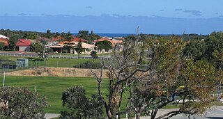
Kinross is a small suburb in the City of Joondalup located in the northern suburbs of Perth in Western Australia. Kinross was constructed around 1992–1993 in various stages. It is bordered by Neerabup National Park to the northeast, Tamala Park to the north, Burns Beach to the west and Currambine to the south. It is the City of Joondalup's northernmost suburb.

Currambine is a northern suburb of Perth, the capital city of Western Australia, 29 km north of Perth's central business district. Its local government area is the City of Joondalup.
The Mitchell Freeway is a 41.5-kilometre-long (25.8 mi) freeway in the northern suburbs of Perth, Western Australia, linking central Perth with the city of Joondalup. It is the northern section of State Route 2, which continues south as Kwinana Freeway and Forrest Highway. Along its length are interchanges with several major roads, including the Graham Farmer Freeway and Reid Highway. The southern terminus of the Mitchell Freeway is at the Narrows Bridge, which crosses the Swan River, and the northern terminus is at Romeo Road in Alkimos.

Clarkson is an outer northern suburb of Perth, Western Australia, located 34 kilometres north of Perth's central business district in the City of Wanneroo.

Merriwa is a coastal, northern suburb of Perth, Western Australia, 36 kilometres (22 mi) north of the central business district. It is part of the City of Wanneroo local government area. It is a predominantly residential suburb, containing two RAAF retirement villages.
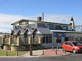
Burns Beach is a suburb of Perth, Western Australia, located 34 kilometres (21 mi) north of Perth's central business district at the northern fringe of the City of Joondalup. Burns Beach has maintained much of its original character as a small coastal village even with its loss of isolation, and the beach is popular among hang gliding enthusiasts.

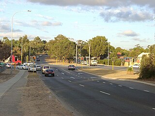
Wanneroo Road is a 44-kilometre (27 mi) arterial highway in the northern suburbs of Perth, Western Australia linking Joondanna and Yokine in the south with Wanneroo and Yanchep in the north. As part of State Route 60, it begins from Charles Street in the inner city and becomes Indian Ocean Drive up to Dongara.

Reid Highway is a 23-kilometre (14 mi) east-west highway and partial freeway in the northern suburbs of Perth, Western Australia, linking North Beach with Middle Swan. As part of State Route 3, it forms half of Perth's outer ring road along with Roe Highway, which it joins onto at its eastern terminus.

Marmion Avenue is a 40-kilometre (25 mi) arterial road in the northern coastal suburbs of Perth, Western Australia, linking Trigg in the south with Yanchep in the north. It forms part of State Route 71 along with West Coast Highway, which it joins onto at its southern terminus.
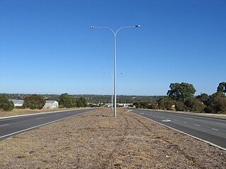
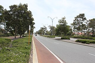
Joondalup Drive is a major distributor road in the northern suburbs of Perth, Western Australia. The road travels through the City of Joondalup's central business district and extends for a few kilometres east through neighbouring residential suburbs in the City of Wanneroo. The road was extended in 2005 to the northern suburb of Banksia Grove to provide easy access for residents to Joondalup's city centre, and to provide a complete connecting route to the Brand Highway from the Mitchell Freeway.
Pinjar Road is a major distributor road in the north-eastern suburbs of Perth, Western Australia, located within the City of Wanneroo.
Beach Road is a major east–west road in the northern suburbs of Perth, Western Australia, connecting Perth's inner northern beachside suburbs and inland state housing areas with shopping and public transport facilities at Warwick and the Malaga industrial area. It was mostly built between 1967 and 1974, and is a dual carriageway for most of its length, except for a small western part between Marmion Avenue and the coast, which is a minor residential distributor road and is discontinuous at Marmion Avenue. Beach Road also serves as a local government boundary. From Alexander Drive to Wanneroo Road, Beach Road is the boundary with the City of Wanneroo on the northern side and the City of Stirling on the southern side. From Wanneroo Road to the coast Beach Road is the boundary with the City of Joondalup on the northern side and the City of Stirling on the southern side.

Hepburn Avenue is an arterial east–west road in the northern suburbs of Perth, Western Australia. The road links Sorrento in the west with Malaga and Whiteman in the east. It also connects the residential developments that span its length with several local facilities, as well as major road routes into central Perth.
Ocean Reef Road is an arterial east-west road in Perth, Western Australia. It is located within the northern suburbs of Perth, from Ocean Reef in the west, to Landsdale in the east, with a portion travelling northwards along the coast to Iluka.
Shenton Avenue is an east–west distributor road in the northern suburbs of Perth, Western Australia, located within the City of Joondalup. The road primarily links Joondalup's coastal suburbs with the Joondalup central business district, which it passes through. It is also an entrance to the Mitchell Freeway.
Hodges Drive is a main west–east road in Joondalup, north of Perth, Western Australia. It begins in the suburb of Ocean Reef at a T-junction with Boat Habour Quays in the Ocean Reef Marina and runs through the residential areas in Ocean Reef, Connolly and Heathridge, before terminating at Joondalup Drive. The road continues from there as Grand Boulevard. Hodges Drive is a four lane dual-carriageway for its entire length apart from a small section near the interchange with Boat Habour Quays where it becomes a 2 lane road.

Connolly Drive is an arterial road in the outer northern suburbs of Perth, Western Australia. The road takes its name from the Perth suburb of Connolly, which lies just beyond the road's terminus.

Hester Avenue is an east-west distributor road in the northern suburbs of Perth, Western Australia, located within the City of Wanneroo. It primarily links the coastal suburbs of the Clarkson-Butler region to the arterial highway Wanneroo Road in the east.

Burns Beach is an electoral district of the Legislative Assembly of Western Australia. It is located in Perth's northern suburbs, and named after the suburb of Burns Beach.
Neaves Road is an arterial east–west road in the metropolitan area of Perth, Western Australia. It is located within the city's far northern suburbs, connecting Banksia Grove in the west to Bullsbrook in the east.

