Carabooda, Western Australia

Last updated

Carabooda
Perth,  Western Australia
Carabooda Karoborup Road.jpg
View from Wanneroo/Karoborup Roads.
Carabooda, Western Australia
Coordinates 31°35′42″S115°42′47″E / 31.595°S 115.713°E / -31.595; 115.713
Population444 (SAL 2021) [1]
Postcode(s) 6033
Area19.1 km2 (7.4 sq mi)
Location45 km (28 mi) NNW of Perth CBD
LGA(s) City of Wanneroo
State electorate(s) Mindarie
Federal division(s) Pearce
Suburbs around Carabooda:
Yanchep Yanchep Yanchep
Eglinton Carabooda Yanchep
Alkimos Nowergup Nowergup

Carabooda is a rural locality in outer northern Perth, Western Australia. Its local government area is the City of Wanneroo.

Contents

The region gives its name to a distinctive form of building limestone called Carabooda limestone. An abandoned theme park is located on Karoborup Road - it was known as Dizzy Lamb Park, and specialised in vintage cars and military vehicles until its closure in 2000.

History

The suburb of Carabooda (spelled Karoborup or Karroborup in earlier documents) takes its name from the lake nearby. The lake name was first recorded by J.W. Gregory in January 1843, and is a Noongar word. The current spelling was in use by 1867, and it was approved as a suburb name in 1982. [2] The name "Karoborup" survives in a regional road through the suburb.

Geography

Carabooda is bounded by Romeo Road/Karoborup Road to the south, the proposed Mitchell Freeway to the west, Cutler Road and Old Yanchep Road to the east and Walding Road (near the Yanchep turnoff) to the north. [3]

At the Australian Bureau of Statistics 2011 census, Carabooda had a population of 737 people living in 316 dwellings, an increase of 227 from the 2006 census. [4] Carabooda is a sparsely populated agricultural suburb, and several plant nurseries and wineries and a wildlife park are located in the area. [3]

Transport

Carabooda was served by the Transperth 490 bus route between Clarkson train station and Two Rocks along Wanneroo Road. However, the service was relocated to Marmion Avenue and the nearby suburb of Yanchep on 14 December 2008, and Carabooda is no longer served. [5]

Politics

Carabooda's political leanings are unclear due to its small size and the lack of a polling booth. The nearest large booths tend to favour the Australian Labor Party historically, although most have been won by the Coalition in recent times, especially at federal level.

Related Research Articles

Balga is a suburb of Perth, the capital city of Western Australia, 13 kilometres (8 mi) north of Perth city's central business district (CBD). Its local government area is the City of Stirling. Mark Irwin is the current mayor.

<span class="mw-page-title-main">Westminster, Western Australia</span> Suburb of Perth, Western Australia

Westminster is a suburb approximately 12 kilometres north of Perth, Western Australia. Its local government area is the City of Stirling.

<span class="mw-page-title-main">City of Wanneroo</span> Local government area in Western Australia

The City of Wanneroo is a local government area with city status in the northern suburbs of Perth, Western Australia. It is centred approximately 25 kilometres (15.5 mi) north of Perth's central business district and forms part of the northern boundary of the Perth metropolitan area. Wangara encompasses the federal divisions of Cowan, Moore and Pearce.

<span class="mw-page-title-main">Nowergup, Western Australia</span> Suburb of Perth, Western Australia

Nowergup is a rural locality about 40 kilometres (25 mi) north of Perth, Western Australia. It is in the local government area of the City of Wanneroo.

<span class="mw-page-title-main">Yanchep</span> Suburb of Perth, Western Australia

Yanchep is an outer coastal suburb of Perth, Western Australia, 56 kilometres (35 mi) north of the Perth CBD. It is a part of the City of Wanneroo local government area. Originally a small crayfishing settlement, it was developed by entrepreneur Alan Bond in the 1970s for the 1977 America's Cup. The area covers the urban centre of Yanchep as well as Yanchep National Park in its entirety.

<span class="mw-page-title-main">Alkimos, Western Australia</span> Suburb of Perth, Western Australia

Alkimos is a coastal suburb of Perth, Western Australia, located 42 kilometres (26 mi) north-northwest of Perth's central business district. It is part of the City of Wanneroo local government area.

Ashby is a suburb of Perth, the capital city of Western Australia 26 kilometres (16 mi) north of Perth's central business district. Its local government area is the City of Wanneroo.

<span class="mw-page-title-main">Butler, Western Australia</span> Suburb of Perth, Western Australia

Butler is an outer suburb of Perth, Western Australia, 41 kilometres north of Perth's central business district. It is part of the City of Wanneroo local government area. It forms the majority of the Brighton Estate, a large commercial and residential development by Satterley.

<span class="mw-page-title-main">Eglinton, Western Australia</span> Suburb of Perth, Western Australia

Eglinton is a locality in the Western Australian capital city of Perth, approximately 44 kilometres (27 mi) north of Perth's central business district on the Indian Ocean. For the most part, the suburb is covered in native banksia woodland, scrubland and heath typical of the Swan Coastal Plain. However, in recent years, there has been growth in residential estates, with a town centre to be built in the near future.

<span class="mw-page-title-main">Girrawheen, Western Australia</span> Suburb of Perth, Western Australia

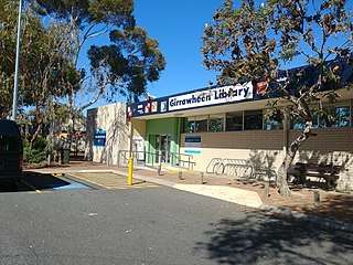
Girrawheen is a northern suburb of Perth, the capital city of Western Australia. Its local government area is the City of Wanneroo.

<span class="mw-page-title-main">Jindalee, Western Australia</span> Suburb of Perth, Western Australia

Jindalee is an outer coastal suburb of Perth, Western Australia, located approximately 40 kilometres (25 mi) north of the Perth central business district. Its local government area is the City of Wanneroo.

Landsdale is a northern suburb of Perth, Western Australia located within the local government area of the City of Wanneroo. It is mixed use, with residential, commercial and light manufacturing areas.

<span class="mw-page-title-main">Mindarie, Western Australia</span> Suburb of Perth, Western Australia

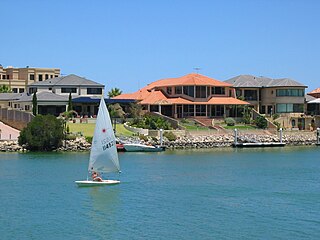
Mindarie is an outer coastal suburb of Perth, Western Australia. It is located 36 kilometres (22 mi) north of Perth's central business district, and forms part of the City of Wanneroo local government area.

<span class="mw-page-title-main">Neerabup, Western Australia</span> Suburb of Perth, Western Australia

Neerabup is a rural locality in Perth, the capital of Western Australia, within the local government area of the City of Wanneroo.

Pinjar is a rural locality in Perth, Western Australia. Its local government area is the City of Wanneroo.

<span class="mw-page-title-main">Quinns Rocks, Western Australia</span> Suburb of Perth, Western Australia

Quinns Rocks is an outer coastal suburb of Perth, Western Australia, located 38 kilometres (24 mi) north of Perth's central business district. It is part of the City of Wanneroo local government area. The suburb was formally established in 1962 as a rural townsite, focused around Quinns Beach, the area's main amenity.

<span class="mw-page-title-main">Ridgewood, Western Australia</span> Suburb of Perth, Western Australia

Ridgewood is an outer suburb of Perth, Western Australia, located 37 kilometres north of Perth's central business district. It is part of the City of Wanneroo local government area.

<span class="mw-page-title-main">Two Rocks</span> Suburb of Perth, Western Australia

Two Rocks is an outer suburb at the northern edge of Perth, the state capital of Western Australia, located 61 kilometres (38 mi) northwest of the city's central business district. It is part of the City of Wanneroo local authority and represents the furthest northern extent of the Perth metropolitan region.

<span class="mw-page-title-main">Burns Beach, Western Australia</span> Suburb of Perth, Western Australia

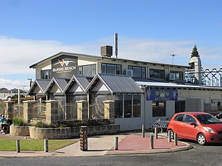
Burns Beach is a suburb of Perth, Western Australia, located 34 kilometres (21 mi) north of Perth's central business district at the northern fringe of the City of Joondalup. Burns Beach has maintained much of its original character as a small coastal village even with its loss of isolation, and the beach is popular among hang gliding enthusiasts.

<span class="mw-page-title-main">Stirling, Western Australia</span> Suburb of Perth, Western Australia

Stirling is a suburb of Perth, the capital city of Western Australia, about 10 km north of Perth's central business district (CBD) along the Mitchell Freeway. Its local government area is the City of Stirling, whose council offices and administration centre are located in the southwest of the mostly residential suburb.

References

  1. Australian Bureau of Statistics (28 June 2022). "Carabooda (suburb and locality)". Australian Census 2021 QuickStats. Retrieved 28 June 2022.  OOjs UI icon edit-ltr-progressive.svg
  2. "History of metropolitan suburb names – C". Western Australian Land Information Authority. Archived from the original on 16 March 2022. Retrieved 15 May 2007.
  3. 1 2 Department of Land Information. StreetSmart Perth Street Directory (54th ed.). West Australian Newspapers Ltd. pp. Maps 129-130. ISBN   978-0-909439-67-5.
  4. Australian Bureau of Statistics (31 October 2012). "2011 Community Profiles: State Suburbs: Carabooda". 2011 Census of Population and Housing. Retrieved 4 July 2012. OOjs UI icon edit-ltr-progressive.svg
  5. Transperth (4 December 2008). "Route 490 & new School Special 718 - service change" . Retrieved 26 May 2010.