Landsdale, Western Australia

Last updated

Landsdale
Perth,  Western Australia
Landsdale, Western Australia
Coordinates 31°48′32″S115°50′20″E / 31.809°S 115.839°E / -31.809; 115.839 Coordinates: 31°48′32″S115°50′20″E / 31.809°S 115.839°E / -31.809; 115.839
Population15,401 (SAL 2021) [1]
Postcode(s) 6065
Area8.5 km2 (3.3 sq mi)
LGA(s) City of Wanneroo
State electorate(s) Landsdale
Federal division(s) Pearce
Suburbs around Landsdale:
Wangara Gnangara Gnangara
Darch Landsdale Cullacabardee
Marangaroo Alexander Heights Ballajura

Landsdale is a northern suburb of Perth, Western Australia located within the local government area of the City of Wanneroo. It is mixed use, with residential, commercial and light manufacturing areas.

Contents

History

In the late 1990s, Landsdale began to develop from market gardens and small rural lots into residential development. Until 1997–1998, prior to the separation by the City of Wanneroo of the suburbs of Darch and Madeley, Landsdale enclosed a much larger area extending westwards to Wanneroo Road.[ citation needed ]

Facilities

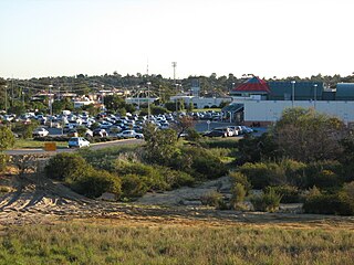
The main commercial precinct is known as Landsdale Gardens and includes most of the facilities of the area, such as a small medical complex, the Warradale centre (named after Warradale Park), parks and reserves, lakes, walking trails, Landsdale Forum shopping centre.

The Warradale Centre (named after nearby Warradale Park on Southmead Drive) is used for community events and includes a club room and change rooms as well as a canteen, parking and toilet facilities. It is used for local sporting clubs including; the Kingsway Rockets Football Club, the Landsdale Lions Junior and Senior Cricket Club as well as a small tee ball club.

Landsdale also has an ambulance station located on the corner of Alexander Drive and Gnangara Road.

The Perth International Telecommunications Centre is located in the eastern end of Landsdale.


Schools

Landsdale has 3 Primary Schools and 1 High School, 1 in the south called Carnaby Rise Primary School and one in the centre called Landsdale Primary School. There is a new Primary School opening in February 2023 called Landsdale Gardens Primary School. The only High School is Landsdale Christian School.

Transport

Landsdale is serviced by three Transperth bus routes, operated by Path Transit and Swan Transit; Route 376 from Mirrabooka bus station and to Whitfords railway station, and the 450 to Warwick railway station, allowing Landsdale residents to connect by train to Perth's central business district; and the 355 goes to Whitfords Station as well via Gnangara Road, with the other way goes to Ellenbrook.

Related Research Articles

Balga is a suburb of Perth, the capital city of Western Australia, 13 kilometres (8 mi) north of Perth city's central business district (CBD). Its local government area is the City of Stirling. Mark Irwin is the current mayor.

Greenwood, Western Australia Suburb of Perth, Western Australia

Greenwood is a suburb of Perth, Western Australia, located in the City of Joondalup. The suburb is located 18 km from Perth's central business district. It is bordered by the Mitchell Freeway, Hepburn ave, Wanneroo road and Warwick road.

Joondalup Suburb of Perth, Western Australia

Joondalup is a suburb of Perth, Western Australia, approximately 26 kilometres (16 mi) north of Perth's central business district. It contains the central business district of the regional City of Joondalup and acts as the primary urban centre of Perth's outer northern suburbs.

Duncraig, Western Australia Suburb of Perth, Western Australia

Duncraig is a northern suburb of Perth, the capital city of Western Australia, and is located 16 kilometres (10 mi) north of Perth's central business district (CBD) between Marmion Avenue and Mitchell Freeway. Its local government area is the City of Joondalup.

Carramar is a suburb of Perth, Western Australia, located within the City of Wanneroo and it is situated 30 km from the Perth CBD. Its postcode is 6031, and it came into being, together with Tapping to the south, in 1995 as a subdivision of Neerabup.

<span class="mw-page-title-main">Clarkson, Western Australia</span> Suburb of Perth, Western Australia

Clarkson is an outer northern suburb of Perth, Western Australia, located 34 kilometres north of Perth's central business district in the City of Wanneroo.

Darch is a suburb of Perth, Western Australia, located within the City of Wanneroo approximately 17 kilometres (11 mi) north of the central business district. Previously part of Landsdale, much of the suburb was rural in character until the late 1990s. It was named after an early settler family in the area, with the name being approved in 1997. The area was subsequently opened to residential development, especially from 2001 onwards, as part of Cell 6 of the East Wanneroo Development Area.
Girrawheen, Western Australia Suburb of Perth, Western Australia

Girrawheen is a northern suburb of Perth, the capital city of Western Australia. Its local government area is the City of Wanneroo.

Gnangara is a suburb of Perth, Western Australia, located within the City of Wanneroo. Gnangara is also the name for an underground water mound with a 117-hectare surface feature called Lake Gnangara.

Wangara, Western Australia Suburb of Perth, Western Australia

Wangara is a light industrial suburb of Perth, Western Australia, located within the City of Wanneroo.

Merriwa, Western Australia Suburb of Perth, Western Australia

Merriwa is a coastal, northern suburb of Perth, Western Australia, 36 kilometres (22 mi) north of the central business district. It is part of the City of Wanneroo local government area. It is a predominantly residential suburb, containing two RAAF retirement villages.

Beldon is a small suburb of Perth, Western Australia, located within the City of Joondalup, to the north of Craigie.

Heathridge is a suburb of Perth, Western Australia, located 33 kilometres (21 mi) south of Yanchep within the City of Joondalup.

Kingsley, Western Australia Suburb of Perth, Western Australia

Kingsley is a suburb of Perth, Western Australia, located within the City of Joondalup. Kingsley is bounded to the north by Whitfords Avenue, to the south by Hepburn Avenue, to the west by the Mitchell Freeway and to the east by Wanneroo Road.

Woodvale, Western Australia Suburb of Perth, Western Australia

Woodvale is a suburb of Perth, Western Australia, located within the City of Joondalup and the City of Wanneroo. At the 2016 census Woodvale had a population of 9,276.

Ellenbrook, Western Australia Suburb of Perth, Western Australia

Ellenbrook is a northeastern suburb of Perth, Western Australia, about 30 km (19 mi) from Perth's central business district (CBD), located within the City of Swan. Ellenbrook, and its neighbouring suburbs of The Vines and Aveley, are unusual for Perth in being a significant distance from neighbouring suburbs. Given this relative isolation and the distance from the CBD, Ellenbrook has been designed and developed as a self-sustainable community. Since the upgrade of Gnangara Road and the completion of the Tonkin Highway Northlink, access to Ellenbrook has improved. The Morley–Ellenbrook railway line is well underway as at June 2021 and this will enable better public transport. At the time of the 2016 census there were 22,681 people living in the gazetted suburb, by June 2018, it was estimated that the urban population for Ellenbrook and surrounds had grown to 41,382. It is envisioned that Ellenbrook will eventually become a satellite city, with a population of 80,000.

Cullacabardee, Western Australia Suburb of Perth, Western Australia

Cullacabardee is a northeastern rural suburb of Perth, the capital city of Western Australia, located 21 km (13 mi) from Perth's central business district via Alexander Drive or Beechboro Road. It is in the City of Swan local government area. Most of the suburb is covered in native sheoak and banksia forest. A small Noongar community is based on Baal Street, a drug rehabilitation retreat is located off Gnangara Road in the suburb's northeast, and the Perth International Telecommunications Centre facility is based in the suburb's northwest.

Alexander Drive Road in Perth, Western Australia

Alexander Drive is a major north–south arterial road in the northern suburbs of Perth, Western Australia, connecting Perth's central business district (CBD) with Edith Cowan University's Mount Lawley campus and the Malaga industrial area, as well as newer development suburbs to Perth's north. It is used by Transperth bus routes, including the 360, 361 and 362. Alexander Drive was named after Mr S.B. Alexander, a former Wanneroo Road Board member. Alexander Drive runs through the following local government areas City of Wanneroo, City of Swan, City of Bayswater and City of Stirling.

Hepburn Avenue Road in Perth, Western Australia

Hepburn Avenue is an arterial east-west road in the northern suburbs of Perth, Western Australia. The road links Sorrento in the west with Malaga and Whiteman in the east. It also connects the residential developments that span its length with several local facilities, as well as major road routes into central Perth.

Ocean Reef Road Road in Perth, Western Australia

Ocean Reef Road is an arterial east-west road in Perth, Western Australia. It is located within the northern suburbs of Perth, from Ocean Reef in the west, to Landsdale in the east, with a portion travelling northwards along the coast to Iluka.

References

  1. Australian Bureau of Statistics (28 June 2022). "Landsdale (Suburb and Locality)". Australian Census 2021 QuickStats. Retrieved 28 June 2022.  OOjs UI icon edit-ltr-progressive.svg