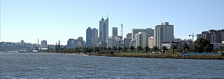
Perth Water is a section of the Swan River on the southern edge of the central business district of Perth, Western Australia. It is between the Causeway to the east, and Narrows Bridge to the west – a large wide but shallow section of river, and the northern edge of the suburb South Perth. It is considered a landmark of the City of Perth.

Kwinana Beach is an outer southwestern suburb of Perth, Western Australia, located within the City of Kwinana. It is one of the traditional industrial suburbs in the Perth metropolitan region.

Barrack Street is one of two major cross-streets in the central business district of Perth, Western Australia. Together with St Georges Terrace, Wellington Street and William Street it defines the boundary of the main shopping precinct of the central city.

Barrack Square is an open public square on the foreshore of Perth Water on the Swan River, located at the southern end of Barrack Street near the central business district of Perth, Western Australia.

St Georges Terrace is the main street in the city of Perth, Western Australia. It runs parallel to the Swan River and forms the major arterial road through the central business district.
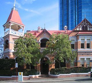
The Weld Club is a private male-only social club in Perth, Western Australia. Founded in 1871 as a gentlemen's club, it is named after Frederick Weld, the chronologically first patron of the club and the Governor of Western Australia at the time.

Middleton Beach is a coastal suburb of Albany, Western Australia, located within the City of Albany approximately 4 kilometres (2.5 mi) east of the city centre. The traditional owners, the Noongar peoples, know the place as Binalup meaning the place of first light since the sun rises over the waters in the morning. The main road between the city and the locality is via Middleton Road. It is home to a caravan park and numerous holiday units which provide accommodation for visitors to the Albany region.

Wellington Street is the northernmost of the four primary east-west streets in the central business district of Perth, Western Australia. It is 3.7 kilometres (2.3 mi) long, stretching from Plain Street in East Perth to Thomas Street in West Perth.

William Street is a suburban distributor and one of two major cross-streets in the central business district of Perth, Western Australia. Commencing in western Mount Lawley, its route takes it through the Northbridge café and nightclub district as well as the CBD.

Beaufort Street is a major road in the inner north-eastern suburbs of Perth, Western Australia, connecting the Morley area to the Perth central business district. For most of its length, it is a single-carriageway, two-way road with two lanes in each direction.

Supreme Court Gardens is a park in the central business district of Perth, Western Australia, bounded by Riverside Drive, Barrack Street, Governors Avenue, and the buildings of the Supreme Court of Western Australia.

The Perth tramway network served Perth, the capital city of Western Australia, from 1899 until 1958. The network was initially run by a private company but was taken over by the state government in 1913. From a single line along Hay Street, the network expanded north as far as Osborne Park, east as far as Welshpool, south as far as Como, and west as far as Claremont. The tramways were gradually replaced by buses after World War II.
The Esplanade Reserve in Perth, Western Australia, was a heritage listed public space between Perth Water and the Perth central business district. The public space was resumed by the Western Australian state government in April 2012 as part of the Elizabeth Quay redevelopment of the Perth waterfront area.

The north shore of Perth Water on the Swan River frontage to the city of Perth in Western Australia has been frequently changed since the arrival of Europeans in 1829. Various forms and structures have appeared and been removed over the last 190 years. Jetties, ports and various forms of reclamation have moved the shore considerably into Perth Water. The main eras of reclamation were in the 1870s, 1900s, 1920s-1937, 1955–1959, and 1967.

Riverside Drive in Perth, Western Australia, is a road on the northern side of Perth Water. It was built on reclaimed land in the 1930s, and links The Causeway to the Narrows Bridge.

Elizabeth Quay is a mixed-use development project in the Perth central business district. Encompassing an area located on the north shore of Perth Water near the landmark Swan Bells, the precinct was named in honour of Queen Elizabeth II during her Diamond Jubilee.

The Esplanade Hotel is a hotel located opposite Esplanade Park in Fremantle, Western Australia. The building stands on the site of the first building used for housing convicts transported from Great Britain in 1850.

The Atlas Building is a heritage-listed building in Perth, Western Australia. It is located in the Perth central business district at 8–10 The Esplanade, and sits along the south-western side of Sherwood Court.
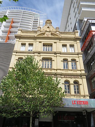
Bon Marché Arcade, also known as Bon Marché Buildings, is a heritage-listed building in Perth, Western Australia], located at 74–84 Barrack Street in the Perth central business district. It is three and four storeys tall, built in 1901 from brick in the Federation Free Classical architectural style, with a tin roof. Designed by architect H. J. Prockter, it was a prominent feature in Barrack Street when constructed, being taller than the one or two story buildings surrounding it.
