Beaconsfield, Western Australia

Last updated

Beaconsfield
Perth,  Western Australia
WTF Charlie's Team Christ the King Church.jpeg
Christ the King Church, Beaconsfield
Beaconsfield, Western Australia
Coordinates 32°04′10″S115°46′07″E / 32.0693877°S 115.768587°E / -32.0693877; 115.768587 (Beaconsfield)
Population5,315 (SAL 2021) [1]
Postcode(s) 6162
LGA(s) City of Fremantle
State electorate(s) Fremantle
Federal division(s) Fremantle
Suburbs around Beaconsfield:
Fremantle White Gum Valley Hilton
South Fremantle Beaconsfield Hilton
South Fremantle Hamilton Hill Hamilton Hill

Beaconsfield is a suburb of Perth, Western Australia, located within the City of Fremantle. It was named after a property of the same name in the area in the 1880s; the name was officially adopted from the post office on 1 August 1894. The name's origin is unknown, but it probably comes from the town in England or the Earl of Beaconsfield, Benjamin Disraeli, a former Conservative Prime Minister of the United Kingdom. [2]

Contents

Beaconsfield is predominantly a low to medium density residential suburb with extensive community facilities including Fremantle College, several primary schools, and an array of open space recreation reserves and local shops.

Facilities and amenities

Parks and playgrounds

Transport

Bus

Bus routes serving Hampton Road:

Schools and education

There are a number of schools in the suburb including several primary and one high school.

Sporting clubs

Shops and shopping centre

Notable citizens

Related Research Articles

Dianella is a suburb of Perth, Western Australia. It is within the local government area of the City of Stirling.

<span class="mw-page-title-main">Tuart Hill, Western Australia</span> Suburb of Perth, Western Australia

Tuart Hill is a suburb of Perth, Western Australia.

<span class="mw-page-title-main">Claremont, Western Australia</span> Suburb of Perth, Western Australia

Claremont is a western suburb of Perth, Western Australia, on the north bank of the Swan River.

<span class="mw-page-title-main">Bull Creek, Western Australia</span> Suburb of Perth, Western Australia

Bull Creek is a suburb of Perth, Western Australia, located within the local government area of City of Melville. The suburb lies to the south of a creek of the same name, which flows into the Canning River.

Cloverdale is a suburb of Perth, the capital city of Western Australia, 10 kilometres (6 mi) east of Perth's CBD in the City of Belmont.

<span class="mw-page-title-main">Morley, Western Australia</span> Suburb of Perth, Western Australia

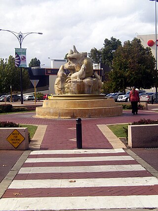
Morley is a suburb of Perth, within the City of Bayswater local government area, situated approximately 10 kilometres (6 mi) northeast of the Perth central business district. It contains the Galleria Shopping Centre, one of Perth's larger shopping centres. Morley bus station is located in the car park of the shopping centre. From the late 1950s, Morley began to develop as a major shopping and commercial centre.

<span class="mw-page-title-main">Coolbellup, Western Australia</span> Suburb of Perth, Western Australia

Coolbellup is a suburb in Perth, Western Australia, located 15 kilometres (9.3 mi) south of the central business district within the local government area of the City of Cockburn.

<span class="mw-page-title-main">Riverton, Western Australia</span> Suburb of Perth, Western Australia

Riverton is a southeastern suburb of Perth, the capital city of Western Australia. Its local government area is the City of Canning.

Shelley is a suburb of Perth, Western Australia, located within the City of Canning.

St James is a suburb shared between the Town of Victoria Park and the City of Canning in the Perth metropolitan area.

<span class="mw-page-title-main">Willetton, Western Australia</span> Suburb of Perth, Western Australia

Willetton is a large southern suburb of Perth, Western Australia. Its local government area is the City of Canning.

<span class="mw-page-title-main">White Gum Valley, Western Australia</span> Suburb of Perth, Western Australia

White Gum Valley is a suburb of Perth, Western Australia located within the City of Fremantle. It is situated behind the main ridge that lies east of Fremantle.

<span class="mw-page-title-main">Samson, Western Australia</span> Suburb of Perth, Western Australia

Samson is a suburb of Perth, Western Australia in the City of Fremantle. Samson is bounded by South Street to the north, Stock Road to the west, Winterfold Road to the south, South Street to the north and east no further than Rushby and McMahon Ways.

<span class="mw-page-title-main">Hilton, Western Australia</span> Suburb of Perth, Western Australia

Hilton is a suburb of Perth, Western Australia, located within the City of Fremantle.

<span class="mw-page-title-main">East Victoria Park, Western Australia</span> Suburb of Perth, Western Australia

East Victoria Park is an inner south-eastern suburb of Perth, Western Australia, located within the Town of Victoria Park.

<span class="mw-page-title-main">Stirling, Western Australia</span> Suburb of Perth, Western Australia

Stirling is a suburb of Perth, the capital city of Western Australia, about 10 km north of Perth's central business district (CBD) along the Mitchell Freeway. Its local government area is the City of Stirling, whose council offices and administration centre are located in the southwest of the mostly residential suburb.

<span class="mw-page-title-main">Belmont, Western Australia</span> Suburb of Perth, Western Australia

Belmont is a suburb of Perth, the capital city of Western Australia, and is located 7 kilometres (4 mi) east of Perth's central business district on the southern bank of the Swan River. Its local government area is the City of Belmont.

<span class="mw-page-title-main">East Fremantle, Western Australia</span> Suburb of Perth, Western Australia

East Fremantle is a suburb of Perth, Western Australia, located 13 kilometres (8.1 mi) south-west of the central business district. The suburb is mainly residential, and is coterminous with the Town of East Fremantle local government area.

<span class="mw-page-title-main">Nedlands, Western Australia</span> Suburb of Perth, Western Australia

Nedlands is a western suburb of Perth, the capital city of Western Australia. It is a part of the local government areas of the City of Nedlands and the City of Perth. It is about 7 kilometres (4 mi) from the Perth CBD via either Thomas Street or Mounts Bay Road.

<span class="mw-page-title-main">Fremantle (suburb)</span> Suburb of Perth, Western Australia

Fremantle is a Western Australian suburb located in Perth at the mouth of the Swan River, and is situated 18 kilometres (11 mi) from the Perth central business district. One of the original settlements of the Swan River Colony established in 1829 is within the area known today as this suburb.

References

  1. Australian Bureau of Statistics (28 June 2022). "Beaconsfield (WA) (suburb and locality)". Australian Census 2021 QuickStats. Retrieved 28 June 2022.  OOjs UI icon edit-ltr-progressive.svg
  2. Unknown. "Perth and surrounds suburb names". www0.landgate.wa.gov.au. Retrieved 5 June 2022.
  3. "Route 114". Bus Timetable 118 (PDF). Transperth. 8 May 2024 [effective from 15 July 2024].
  4. "Route 160". Bus Timetable 34 (PDF). Transperth. 8 May 2024 [effective from 15 July 2024].
  5. "Route 511". Bus Timetable 37 (PDF). Transperth. 12 June 2024 [effective from 15 July 2024].
  6. "Route 513". Bus Timetable 37 (PDF). Transperth. 12 June 2024 [effective from 15 July 2024].
  7. "Route 532". Bus Timetable 120 (PDF). Transperth. 11 June 2024 [effective from 15 July 2024].
  8. "Route 998". CircleRoute Timetable 200 (PDF) (CircleRoute). Transperth. 12 June 2024 [effective from 15 July 2024].
  9. "Route 999". CircleRoute Timetable 200 (PDF) (CircleRoute). Transperth. 12 June 2024 [effective from 15 July 2024].
  10. "Route 512". Bus Timetable 37 (PDF). Transperth. 12 June 2024 [effective from 15 July 2024].
  11. "Route 520". Bus Timetable 119 (PDF). Transperth. 8 May 2024 [effective from 15 July 2024].
  12. "Route 530". Bus Timetable 121 (PDF). Transperth. 11 June 2024 [effective from 15 July 2024].
  13. "Route 531". Bus Timetable 121 (PDF). Transperth. 11 June 2024 [effective from 15 July 2024].
  14. "Route 548". Bus Timetable 126 (PDF). Transperth. 9 May 2024 [effective from 15 July 2024].
  15. "Route 549". Bus Timetable 125 (PDF). Transperth. 17 August 2022 [effective from 10 October 2022].
  16. "Home". beaconsfieldps.wa.edu.au.
  17. http://www.winterfoldps.wa.edu.au Winterfold
  18. "Home". ctk.wa.edu.au.
  19. "WA Police Force Commissioners". Western Australian Police Force. 1 September 2022. Archived from the original on 13 April 2024. Retrieved 16 September 2024.
  20. "On my bedside table". The West Australian. 26 January 2008. p. 26 (West Weekend Magazine). Mr Tagliaferri lives in Beaconsfield, with his wife Albina, two teenage daughters, Liana and Georgina, and a St Bernard dog called Revlon.

Commons-logo.svg Media related to Beaconsfield, Western Australia at Wikimedia Commons