Manuwarra Red Dog Highway

Last updated

Manuwarra Red Dog Highway

General information
TypeHighway  (Under construction)
Length182 km (113 mi)
Opened
  • December 2003 (Stage One)
  • August 2008 (Stage Two)
  • September 2020 (Stage Three)
Route number(s) Australian state route 142.svg State Route 142
Major junctions
North-west endAustralian national route 1.svg North West Coastal Highway (National Route 1), Karratha
 
South-east endTom Price–Paraburdoo Road/Bingarn Road intersection, Tom Price
Location(s)
Region Pilbara
Highway system

Manuwarra Red Dog Highway is a major road currently under construction in the Pilbara region of Western Australia, between Karratha and Tom Price. Originally known as Karratha–Tom Price Road, it acquired its new name in September 2020 after community consultation. [1]  Manuwarra means "'heaps' or 'masses'" in the Yindjibarndi language and is the indigenous name for the Red Dog Gorge in the Millstream Chichester National Park. Both the gorge and the highway acquired its English name from the eponymous Red Dog, a famous Kelpie/Cattle Dog and Pilbara mascot from the 1970s. [2]

Contents

History

The need for a more direct sealed road between the areas surrounding Karratha and Tom Price was identified in the 1990s. Before Stages one to three of Manuwarra Red Dog Highway were constructed, access from Karratha to Tom Price (on the public roads) was via the Roebourne–Wittenoom Road, the Nanutarra–Munjina Road and the Tom Price Spur Road. However, historical traffic data showed that most vehicles commuting between Karratha and Tom Price were using the more direct route along the Rio Tinto owned access road for the Dampier to Paraburdoo railway rather than the public roads. [3] However, this route had a high accident rate, and requires a permit to be obtained from Rio Tinto to use the road. [4]

Route description

Manuwarra Red Dog Highway roughly follows the route of the Dampier to Paraburdoo railway for its entire length (including the as-yet incomplete stage four). This is to avoid impacts to the nearby Millstream Chichester National Park and the catchment of the Harding Dam (an important source of drinking water), as well as several Aboriginal heritage sites. [4]

Southern section

From the Tom Price–Paraburdoo Road intersection (where it continues as Bingarn Road into the townsite), the road goes about 250 metres (820 ft) to the west where it passes under the Paraburdoo branch of the Dampier to Paraburdoo railway, and about 250 metres (820 ft) further along it then reaches the Mine Road intersection, which provides access to the Mount Tom Price mine and was previously part of the main access to the town. Here the road turns to the north. It crosses over the Mount Tom Price Mine branch of the Dampier to Paraburdoo Railway about 450 metres (1,480 ft) north of the Mine Road intersection. 1.4 kilometres (0.87 mi) further north, it meets an intersection providing access to the residential area in the north of Tom Price. The road passes the Tom Price landfill about 1.9 kilometres (1.2 mi) further north, where it turns to the north-west for about 4 kilometres (2.5 mi). It then begins to run alongside the railway, turns to the north and continues so for the next 17 kilometres (11 mi), where the southern portion of the road currently ends at Nanutarra–Munjina Road. [5] Here drivers may continue north by travelling a short distance on the Nanutarra–Munjina Road, then (if they possess a permit) turning onto the Rio Tinto owned access road for the Dampier to Paraburdoo railway, or can continue on Nanutarra–Munjina Road to access Roebourne–Wittenoom Road.

Northern section

The constructed road continues just after the railway crossing where the Roebourne–Wittenoom Road crosses the Dampier to Paraburdoo railway. It meets the Railway access road at a T-junction shortly after the crossing. It then roughly follows the railway line for about 22 kilometres (14 mi). It continues west for 12 kilometres (7.5 mi) where it begins to turn to the north-west. 16 kilometres (10 mi) further along it meets the access road for the Millstream Chichester National Park, where it then starts to diverge from the railway line, as the railway turns to the north. It continues north-west for about 9 kilometres (5.6 mi) before turning to the north, and continues until it rejoins the railway about 10 kilometres (6 mi) to the north, near Camp Curlewis. The road then follows the railway, deviating only to avoid terrain constraints, for the next 90 kilometres (56 mi) to Karratha, where it ends at a T-junction with the North West Coastal Highway. [5] Drivers can then use Madigan Road to access the town of Karratha.

Construction

Manuwarra Red Dog Highway is being constructed in four stages.

Stage One, Tom Price to Nanutarra–Munjina Road

Construction on Manuwarra Red Dog Highway (then known as Karratha–Tom Price Road) began in January 2003, with work beginning on the 25-kilometre-long (16 mi). Stage One, which followed the Dampier to Paraburdoo railway corridor from Tom Price north to Nanutarra-Munjina Road, with a budget of $18.7 million. [6] Stage One was completed in December 2003, [7] at a cost of $26 million, and reduced the travel distance by 15 kilometres (9.3 mi). [8]

Stage Two, Karratha to Curlewis

Stage Two of Manuwarra Red Dog Highway was 90 kilometres (56 mi) long and followed the route of the Dampier to Paraburdoo Railway from the northern end of the road at the North West Coastal Highway, about 20 kilometres (12 mi) from Karratha, to a location known as Camp Curlewis, where it met the existing Roebourne–Wittenoom Road. Whilst the northern portion of the route is relatively flat, the southern section was much more challenging, and required significant earthworks. [4] Stage Three had an estimated cost of $80 million. [9] Construction of Stage two started in August 2006 [10] and was completed in August 2008 at a cost of $150 million. [11]

Stage Three, Curlewis to Wallyinya Pool

Stage Three of Manuwarra Red Dog Highway follows the existing, though unsealed, Roebourne–Wittenoom Road for 48 kilometres (30 mi), from Camp Curlewis to Wallyinya Pool, alongside the Dampier to Paraburdoo railway. [4] This portion involved sealing and upgrading the existing road. During construction, traffic was diverted onto the adjacent access road for the Dampier to Paraburdoo railway. [12]

Whilst the terrain was less challenging than for Stage Two, the road had been used for carting asbestos from the mines near Wittenoom to the port. Bags of asbestos would often fall off the trucks on the way, resulting in the road becoming heavily contaminated. The danger posed by the asbestos was such that, in 2018, the Shire of Ashburton, which manages the road, ceased maintaining it on advice from WorkSafe. [13] The contamination issue caused delays to this stage, but work eventually began in September 2019, and was completed in September 2020 at a cost of $81.5 million. [14] [15] At around the same time work was conducted on the section of Roebourne–Wittenoom Road between Wallyinya Pool and Nanutarra–Munjina Road (which was not to be sealed as part of Manuwarra Red Dog Highway), to repair and remediate that section of road, as it had not been maintained for many months, and was in urgent need of repair. [16]

Stage Four, Wallyinya Pool to Nanutarra–Munjina Road

As of October 2021, Stage Four of Manuwarra Red Dog Highway is currently in the design phase, with work underway to identify a final alignment for the road. Construction is expected to start on this 110-kilometre (68 mi) section in early 2022. The estimated cost for Stage Four is around $229 million. [17]

See also

Related Research Articles

<span class="mw-page-title-main">Dampier, Western Australia</span> Town in Western Australia

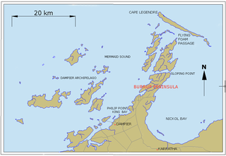
Dampier is a major industrial port in the Pilbara region in the northwest of Western Australia. It is located near the city of Karratha and Port Walcott.
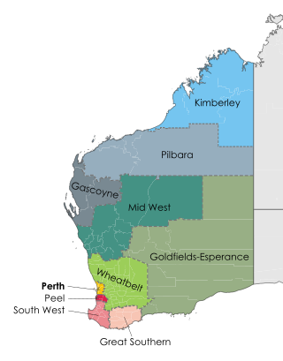
The Pilbara is a large, dry, thinly populated region in the north of Western Australia. It is known for its Aboriginal peoples; its ancient landscapes; the red earth; and its vast mineral deposits, in particular iron ore. It is also a global biodiversity hotspot for subterranean fauna.

<span class="mw-page-title-main">Tom Price, Western Australia</span> Town in Western Australia

Tom Price is a mining town in the Pilbara region of Western Australia. It is located inland, at the edge of the Hamersley Range. Tom Price is the highest town above sea level in Western Australia, and is consequently dubbed "Top Town in WA".

<span class="mw-page-title-main">North West Coastal Highway</span> Highway in Western Australia

North West Coastal Highway is a generally north-south Western Australian highway which links the coastal city of Geraldton with the town of Port Hedland. The 1,300-kilometre-long (808 mi) road, constructed as a sealed two-lane single carriageway, travels through remote and largely arid landscapes. Carnarvon is the only large settlement on the highway, and is an oasis within the harsh surrounding environment. The entire highway is allocated National Route 1, part of Australia's Highway 1, and parts of the highway are included in tourist routes Batavia Coast Tourist Way and Cossack Tourist Way. Economically, North West Coastal Highway is an important link to the Mid West, Gascoyne and Pilbara regions, supporting the agricultural, pastoral, fishing, and tourism industries, as well as mining and offshore oil and gas production.

Karratha is a city in the Pilbara region of Western Australia, adjoining the port of Dampier. It was established in 1968 to accommodate the processing and exportation workforce of the Hamersley Iron mining company and, in the 1980s, the petroleum and liquefied natural gas operations of the North West Shelf Venture. As of the 2021 census, Karratha had an urban population of 17,013. The city's name comes from the cattle station of the same name, which derives from a word in a local Aboriginal language meaning "good country" or "soft earth". The city is the seat of government of the City of Karratha, a local government area covering the surrounding region.

<span class="mw-page-title-main">Roebourne, Western Australia</span> Town in Western Australia

Roebourne is a town in Western Australia's Pilbara region. In the Ngarluma language, Roebourne is called Yirramagardu (Ieramagadu). It is 35 km from Karratha, 202 km from Port Hedland and 1,563 km from Perth, the state's capital. It is the only town on the North West Coastal Highway between Binnu and Fitzroy Crossing; over 2,000km. It is located within the City of Karratha. It prospered during its gold boom of the late 19th century and was once the largest settlement between Darwin and Perth. At the 2016 census, Roebourne and the surrounding area had a population of 981.

<span class="mw-page-title-main">Paraburdoo, Western Australia</span> Town in Western Australia

Paraburdoo is a mining town in the Pilbara region of Western Australia. The region is served by Paraburdoo Airport, which is situated 9 kilometres (5.6 mi) from the town.

<span class="mw-page-title-main">Shire of Ashburton</span> Local government area in Western Australia

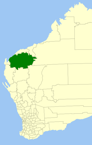
The Shire of Ashburton is one of the four local government areas in the Pilbara region of Western Australia, covering an area of 105,647 square kilometres (40,791 sq mi). It is named after the Ashburton River.

<span class="mw-page-title-main">Hamersley Range</span> Mountain range in Western Australia

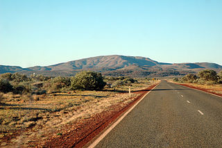
The Hamersley Range is a mountainous region of the Pilbara region of Western Australia. The range was named on 12 June 1861 by explorer Francis Thomas Gregory after Edward Hamersley, a prominent promoter of his exploration expedition to the northwest. Karijini National Park lies within the range.

<span class="mw-page-title-main">Point Samson, Western Australia</span> Town in Western Australia

Point Samson is a small coastal settlement 1,579 km north of Perth and 18 km north of Roebourne in the Pilbara region of Western Australia. The town is a popular holiday location for the nearby mining towns, including Wickham, Karratha and Dampier. Fishing is the main industry.

<span class="mw-page-title-main">City of Karratha</span> Local government area in Western Australia

The City of Karratha is one of the four local government areas in the Pilbara region of Western Australia. It covers an area of 15,882 square kilometres (6,132 sq mi) and had a population of about 21,500 as at the 2016 Census, most of which is located in its seat of government, the city of Karratha, and the major towns. It was formerly known as the Shire of Roebourne but was renamed and granted city status on 1 July 2014.

<span class="mw-page-title-main">Pilbara newspapers</span> Newspapers published in the Pilbara region of Western Australia

Pilbara newspapers is a selection of newspapers published in the Pilbara region of Western Australia.

Dampier Highway, formerly known as Karratha-Dampier Road, is a Western Australian highway linking Dampier on the state's north-western coast with the nearby regional centre of Karratha. The 19.3 kilometres (12 mi) long highway is also the primary thoroughfare for both communities to access the Karratha Airport, as well as industrial facilities including the Pluto LNG project and Murujuga National Park located on the Burrup Peninsula.

<span class="mw-page-title-main">Red Dog (Pilbara)</span> Pilbara Wanderer and Dog of Northwestern Australia

Red Dog was a kelpie/cattle dog cross that was well known for his travels through Western Australia's vast Pilbara region. Red Dog had a series of owners and lengthy periods travelling on his own, essentially becoming a beloved friend and mascot of the greater Pilbara community. A statue was installed in his memory in Dampier, one of the towns to which he often returned. He is frequently referred to as a "red kelpie" or a "red cloud kelpie".

Burrup was an electoral district of the Legislative Assembly in the Australian state of Western Australia from 1996 to 2005.

<span class="mw-page-title-main">Hamersley & Robe River railway</span> Private railway in Pilbara region of Western Australia

The Hamersley & Robe River railway, majority-owned by Rio Tinto, and operated by its subsidiary Pilbara Iron, is a private rail network in the Pilbara region of Western Australia for the purpose of carrying iron ore. The network is larger than any other Australian heavy freight rail network in private ownership. The total length of its track is about 1,700 km (1,056 mi).

Nanutarra is a locality in Western Australia adjacent to where the Ashburton river is crossed by the North West Coastal Highway. It is also close to the turn-off for State Route 136 to Paraburdoo and Tom Price. It is 40 kilometres (25 mi) south of the Onslow turn-off in the Cane River conservation park where it is on either side of the highway.

Main Roads Western Australia controls the major roads in the state's Pilbara region. There are two main highways in the region: Great Northern Highway, which travels north through the region to Port Hedland and then north-west along the coast, as well as North West Coastal Highway, which heads south-west from Port Hedland. A series of main roads connects towns to the highways, and local roads provide additional links. The majority of these roads service the western half of the region, with few located in the various deserts east of the Oakover River. Roads are often named after the towns or areas they connect.

<i>Hamersley News</i>

Hamersley News was a fortnightly English language newspaper published in Perth, Western Australia by Hamersley Iron Pty Ltd. It was distributed to mining communities in Dampier, Karratha, Tom Price and Paraburdoo.

<span class="mw-page-title-main">Cyclone Damien</span> Category 2 Cyclone in 2020

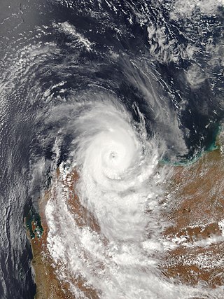
Severe Tropical Cyclone Damien was the strongest cyclone to make landfall on the Western Australian coast since Cyclone Christine in 2013 and the second-strongest cyclone in the 2019–20 Australian region cyclone season after Cyclone Ferdinand. The fifth tropical low, and the third named storm of the 2019–20 Australian region cyclone season, Damien originated from a monsoon trough over Kimberley.

References

  1. "Manuwarra Red Dog Highway naming boosts call for greater use of Indigenous names in ancient Pilbara". Archived from the original on 25 October 2021. Retrieved 25 October 2021.
  2. "Karratha-Tom Price Road officially named Manuwarra Red Dog Highway". Archived from the original on 25 October 2021. Retrieved 25 October 2021.
  3. "Manuwarra Red Dog Highway s38 Referral Supporting Information" (PDF). 1 December 2020. Archived (PDF) from the original on 25 October 2021. Retrieved 25 October 2021.
  4. 1 2 3 4 "Karratha-Tom Price Road CER" (PDF). January 2003. Archived (PDF) from the original on 15 May 2022. Retrieved 15 May 2022.
  5. 1 2 "Road Information Mapping System". mrwebapps.mainroads.wa.gov.au. Archived from the original on 15 September 2021. Retrieved 21 November 2021.
  6. "Tom Price-Karratha Road project under way". 17 January 2003. Archived from the original on 25 October 2021. Retrieved 25 October 2021.
  7. "Tom Price to Karratha (Stage One)". Highway Construction. Archived from the original on 26 October 2021. Retrieved 26 October 2021.
  8. "Premier announces $80million for the Karratha-Tom Price Road". 26 July 2004. Archived from the original on 25 October 2021. Retrieved 25 October 2021.
  9. "Major North-West road project on track". Archived from the original on 26 October 2021. Retrieved 26 October 2021.
  10. "Karratha-Tom Price Road, Stage Two under way". 1 August 2006. Archived from the original on 26 October 2021. Retrieved 26 October 2021.
  11. "Stage Two of the Karratha to Tom Price Road now complete". 3 August 2008. Archived from the original on 27 October 2021. Retrieved 27 October 2021.
  12. "Project Update April 2020" (PDF). Archived (PDF) from the original on 27 October 2021. Retrieved 27 October 2021.
  13. "Critical road upgrade hits deadly delay". The West Australian. 25 May 2019. Archived from the original on 26 October 2021. Retrieved 26 October 2021.
  14. "Joint media statement - Third stage of upgrades to Manuwarra Red Dog Highway now complete". 2 September 2020. Archived from the original on 26 October 2021. Retrieved 26 October 2021.
  15. "Stage 3 of Karratha-Tom Price Road construction underway". 12 September 2019. Archived from the original on 26 October 2021. Retrieved 26 October 2021.
  16. "Action to be taken to improve the old Roebourne-Wittenoom Road". Archived from the original on 26 October 2021. Retrieved 26 October 2021.
  17. "Manuwarra Red Dog Highway". Main Roads Western Australia. Archived from the original on 27 October 2021. Retrieved 27 October 2021.