Major roads in the Mid West region of Western Australia

Last updated

Main Roads Western Australia controls the major roads in the state's Mid West region. [1] There are four main highways through the Mid West: The north-south coastal route of Brand Highway and North West Coastal Highway, the inland alternative Great Northern Highway, and the northern section of Goldfields Highway, which links Meekatharra with Kalgoorlie. A network of main roads connects towns within the Mid West to each other, the highways, and neighbouring regions, with local roads providing additional links and access to smaller townsites. Roads are often named after the towns they connect. [2] [3]

Contents

Freight vehicles, servicing the mining and agricultural industries, make up a significant proportion of the traffic using the Mid West road network. Tourist traffic primarily focuses on the coastal routes, which connect visitors to Dongara, Geraldton, Northampton and Kalbarri, and nearby tourist attractions. [4]

Agnew Sandstone Road

Agnew Sandstone Road
(Mid West region)

Location Sandstone
Length89.76 km [5]  (55.77 mi)

Agnew Sandstone Road is a main east-west road near the north-eastern edge of the Mid West region. From Sandstone, it travels east towards Agnew in the state's Goldfields-Esperance region. [2]

Brand Highway

Brand Highway
(Mid West region)

Location WarradargeGeraldton
Length187.22 km [5]  (116.33 mi)
Route number Australian national route 1.svg National Route 1

Brand Highway is a main north-west to south-east highway in the Mid West region, parallel to the coast. It enters the region a short distance north of the turnoff to Jurien Bay, and continues north-west to Geraldton. [2]

Chapman Valley Road

Chapman Valley Road

Location GeraldtonYuna
Length69.60 km [5]  (43.25 mi)

Chapman Valley Road is a main north-east to south-west road in the Mid West region. From Geraldton, it travels north-east for fourteen kilometres (8.7 mi) [5] as a local road until it intersects Morrell Road in Yetna. From that point on it continues as a main road (Moonyoonooka Yuna Road [5] ) to Nabawa and then onto Yuna. [2]

Coolimba–Eneabba Road

Coolimba–Eneabba Road

Location CoolimbaEneabba
Length27.38 km [5]  (17.01 mi)

Coolimba–Eneabba Road, [1] also known as Coolimba Eneabba Road, [2] Eneabba–Coolimbia Road, [3] or Eneabba Coolimbia Road, [5] is a main east-west road in the south-west of Western Australia's Mid West region. The road connects Indian Ocean Drive at Coolimba with Brand Highway at Eneabba. [2]

Edward Road

Edward Road

Location GeraldtonWalkaway
Length23.62 km [5]  (14.68 mi)

Edward Road is a major road in the Mid West region, linking Geraldton at its north-west end to Walkaway in the south-east. It runs parallel to Brand Highway, but further inland. Several local roads, as well as Geraldton–Mount Magnet Road, connect Edward Road to the highway.

Geraldton–Mount Magnet Road

Geraldton–Mount Magnet Road

Location GeraldtonMount Magnet
Length335.34 km [5]  (208.37 mi)
Route number Australian state route 123.svg State Route 123

Geraldton–Mount Magnet Road, [1] also known as Geraldton Mt Magnet Road, [2] is a major east-west road through the centre of the Mid West region. It forms the entirety of State Route 123, linking the coastal city of Geraldton with Mount Magnet on Great Northern Highway.

George Grey Drive

George Grey Drive

Location GregoryKalbarri
Length57.71 km [5]  (35.86 mi)
Route number Australian state route 139.svg State Route 139

George Grey Drive is a major north-south coastal road in the Mid West region. From Port Gregory Road near Gregory, it travels north to Kalbarri National Park and Kalbarri. [2]

Both George Grey Drive and Port Gregory Road were declared State Route 139 in March 2016 [6]

Goldfields Highway

Goldfields Highway
(Mid West region)

Location Meekatharra
Length122.89 km [5]  (76.36 mi)

Goldfields Highway is a major east-west road that is mostly unsealed. From Meekatharra, it heads east towards Wiluna in the Goldfields-Esperance region. [2]

Great Northern Highway

Great Northern Highway
(Mid West region)

Location Mount GibsonCapricorn
Length842.03 km [3]  (523.21 mi)
Route number Australian national highway 95.svg National Highway 95

Great Northern Highway is a main highway through the Mid West region, and part of the Perth to Darwin national highway. From the northern edge of the Wheatbelt, the highway travels north through Paynes Find, Mount Magnet, Cue, and Meekatharra. It continues north for a further 400 kilometres (250 mi), [3] passing the Kumarina Roadhouse on the way, before continuing into the Pilbara region near Newman. [2]

Indian Ocean Drive

Indian Ocean Drive
(Mid West region)

Location Green HeadArrowsmith
Length86.41 km [3]  (53.69 mi)
Route number Australian state route 60.svg State Route 60

Indian Ocean Drive is a main north-south coastal road in the south-west of Western Australia's Mid West region. From Green Head, it travels north via Leeman and Coolimba to Brand Highway in Arrowsmith, south of Dongara. [2] It is the northern section of State Route 60, which continues south to central Perth. [7]

John Willcock Link

Location Geraldton
Length4.20 km [5]  (2.61 mi)

John Willcock Link is a major urban road in Geraldton, linking the grade separated interchange between Brand Highway and North West Coastal Highway with the West End and the city's port. [2]

Midlands Road

Midlands Road
(Mid West region)

Location WalebingWatheroo
Length77.08 km [5]  (47.90 mi)
Route number Australian state route 116.svg State Route 116

Midlands Road, [1] also known as The Midlands Road, [8] is a major road in the Mid West region. The road enters the region at Gunyidi, continuing north from the Wheatbelt. It travels north-west to Mingenew via Coorow, Carnamah, and Three Springs. Beyond Mingenew, it heads west to Dongara, terminating at Brand Highway. Midlands Roads is the northern section of State Route 116, which continues south to Bindoon. [7]

Mingenew–Morawa Road

Mingenew–Morawa Road

Location MingenewMorawa
Length58.75 km [5]  (36.51 mi)

Mingenew–Morawa Road, [1] also known as Mingenew Morawa Road, [2] is a major east-west road in the Mid West region. From the Midlands Road at Mingenew, it travels east to Mullewa–Wubin Road at Morawa. Mignew–Mullewa Road, which heads north to Mullewa, branches off the road close to its western end at Mignew. [2]

Morrell Road

Morrell Road

Location Narra Tarra
Length4.32 km [5]  (2.68 mi)

Morrell Road is a major north-south road in Narra Tarra, east of Geraldton, that connects Chapman Valley Road with Narra Tarra Moonyoonooka Road. [2] [5]

Mount Magnet Sandstone Road

Mount Magnet Sandstone Road

Location Mount MagnetSandstone
Length153.90 km [5]  (95.63 mi)

Mount Magnet Sandstone Road is a main east-west road in the Mid West region. From Mount Magnet, the road travels east to Sandstone. Through-traffic can continue east on Agnew Sandstone Road. [2]

Mullewa–Wubin Road

Mullewa–Wubin Road
(Mid West region)

Location MayaMullewa
Length194.36 km [5]  (120.77 mi)

Mullewa–Wubin Road, [1] also known as Mullewa Wubin Road, [2] is a major north-west to south-east road near in the Mid West region. The road enters the region at Maya, continuing north from Great Northern Highway at Wubin in the Wheatbelt. It heads north-west towards Mullewa, via Latham, Perenjori, and Morawa. The northern terminus is at Geraldton–Mount Magnet Road. [2]

Narra Tarra Moonyoonooka Road

Narra Tarra Moonyoonooka Road

Location Narra TarraMoonyoonooka
Length10.77 km [5]  (6.69 mi)

Narra Tarra Moonyoonooka Road, [1] also known as Moonyoonooka Narra Tarra Road, [5] is a main north-south road in the Mid West region. The road begins at Geraldton–Mount Magnet Road at Moonyoonooka, and heads north to Narra Tarra, where it becomes Morrell Road. [2]

North West Coastal Highway

North West Coastal Highway
(Mid West region)

Location GeraldtonEurardy
Length180.19 km [5]  (111.96 mi)
Route number Australian national route 1.svg National Route 1

North West Coastal Highway is a main north-south highway in the Mid West region. It begins at a grade separated interchange with Brand Highway in Geraldton, and from there heads north via Northampton to Eurardy at the northern edge of the Mid West region. [2]

Port Gregory Road

Port Gregory Road

Location NorthamptonGregory
Length57.61 km [5]  (35.80 mi)
Route number Australian state route 139.svg State Route 139

Port Gregory Road, [1] also known as Northampton–Port Gregory Road, [5] is a 57.6-kilometre-long (35.8 mi) main east-west road in the Mid West region. From Northampton, it travels west towards the coastal town of Gregory. Just outside the townsite, the road intersects George Grey Drive, and past this point it continues as a local road for the final 5.3 kilometres (3.3 mi). [2]

Both Port Gregory Road and George Grey Drive were declared State Route 139 in March 2016 [9]

See also

Related Research Articles

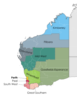
The Mid West region is one of the nine regions of Western Australia. It is a sparsely populated region extending from the west coast of Western Australia, about 200 kilometres (120 mi) north and south of its administrative centre of Geraldton and inland to 450 kilometres (280 mi) east of Wiluna in the Gibson Desert.

Brand Highway Highway in Western Australia

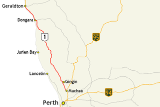
Brand Highway is a 370-kilometre (230 mi) main highway linking the northern outskirts of Perth to Geraldton in Western Australia. Together with North West Coastal Highway, it forms part of the Western Australian coastal link to the Northern Territory. The highway is a part of Australia's Highway 1, and is for the most part a single carriageway with one lane in each direction.

Great Northern Highway Highway in Western Australia

Great Northern Highway is an Australian highway that links Western Australia's capital city Perth with its northernmost port, Wyndham. With a length of almost 3,200 kilometres (2,000 mi), it is the longest highway in Australia, with the majority included as part of the Perth Darwin National Highway. The highway is constructed as a sealed, predominantly two-lane single carriageway, but with some single-lane bridges in the Kimberley. The Great Northern Highway travels through remote areas of the state, and is the only sealed road link between the Northern Territory and northern Western Australia. Economically, it provides vital access through the Wheatbelt and Mid West to the resource-rich regions of the Pilbara and Kimberley. In these areas, the key industries of mining, agriculture and pastoral stations, and tourism are all dependent on the highway.

North West Coastal Highway Highway in Western Australia

North West Coastal Highway is a generally north-south Western Australian highway which links the coastal city of Geraldton with the town of Port Hedland. The 1,300-kilometre-long (808 mi) road, constructed as a sealed two-lane single carriageway, travels through remote and largely arid landscapes. Carnarvon is the only large settlement on the highway, and is an oasis within the harsh surrounding environment. The entire highway is allocated National Route 1, part of Australia's Highway 1, and parts of the highway are included in tourist routes Batavia Coast Tourist Way and Cossack Tourist Way. Economically, North West Coastal Highway is an important link to the Mid West, Gascoyne and Pilbara regions, supporting the agricultural, pastoral, fishing, and tourism industries, as well as mining and offshore oil and gas production.

Morawa, Western Australia Town in Western Australia

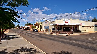
Morawa is a town in the Mid West region of Western Australia. It is located within the Shire of Morawa, approximately 370 kilometres (230 mi) north of the state capital Perth, on the railway line between Wongan Hills and Mullewa.

Electoral district of Moore State electoral district of Western Australia

Moore is an electoral district of the Legislative Assembly in the Australian state of Western Australia.

Roman Catholic Diocese of Geraldton Catholic ecclesiastical territory

The Roman Catholic Diocese of Geraldton is a Latin Rite suffragan diocese in the ecclesiastical province of the Metropolitan Archdiocese of Perth, covering the Mid West, Western Australia.

Shire of Mingenew Local government area in Western Australia

The Shire of Mingenew is a local government area in the Mid West region of Western Australia, about 110 kilometres (68 mi) southeast of the city of Geraldton and about 370 kilometres (230 mi) north of the state capital, Perth. The Shire covers an area of 1,939 square kilometres (749 sq mi), and its seat of government is the town of Mingenew.

Geraldton–Mount Magnet Road Highway in Western Australia

Geraldton–Mount Magnet Road is a 335-kilometre-long (208 mi) major regional road in the Mid West region of Western Australia, starting in Utakarra in Geraldton's eastern suburbs, and terminating 333 kilometres (207 mi) east-northeast at Great Northern Highway near the mining town of Mount Magnet. The road is signed as State Route 123, is a two-lane single carriageway for its entire length, and is a major traffic route which is regularly used by heavy vehicles and mine/grain road trains.

Gutha, Western Australia Town in Western Australia

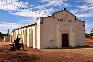
Gutha is a townsite in the Mid West region of Western Australia, 32 kilometres (20 mi) north of Morawa.

Koolanooka is a small town in the MidWest region of Western Australia. It is situated between Morawa and Perenjori just off the Mullewa-Wubin road. At the 2006 census, Koolanooka had a population of 46.

Canna is a small town in the Mid West region of Western Australia. It is located between the towns of Morawa and Mullewa on the Mullewa-Wubin Road. At the 2006 census, Canna had a population of 81.

City of Greater Geraldton Local government area in Western Australia

The City of Greater Geraldton is a local government area in the Mid West region of Western Australia, 424 kilometres (263 mi) north of the state capital, Perth on the Indian Ocean. It covers an area of 12,625.5 square kilometres (4,874.7 sq mi), and its seat of government is the town of Geraldton.

Highway 1 (Western Australia)

In Western Australia, Highway 1 is a 5,305-kilometre (3,296 mi) long route around the state, from the South Australian border near Eucla to the Northern Territory border near Kununurra. Highway 1 continues around the rest of Australia, joining all mainland state capitals, and connecting major centres in Tasmania. All roads within the Highway 1 system are allocated a road route numbered 1, M1, A1, or B1, depending on the state route numbering system. In Western Australia, most of the highway is designated as National Route 1; however, the sections in the north-east and south-east of the state that are concurrent with the National Highway routes linking Perth to Adelaide and Darwin are designated as National Highway 1.

CBH grain receival points Grain receival points in Western Australia

CBH grain receival points are grain silos spread around Western Australia, primarily in the wheatbelt region. Historically they have been linked with the wheatbelt railway lines, and the transport of grain to ports for export.

Major roads in the Wheatbelt region of Western Australia

Highways and main roads in the Wheatbelt region of Western Australia form the basis of a road network, which is primarily used by the mining, agriculture, and tourism industries. Main Roads Western Australia maintains and controls these major roads, with offices based in Northam and Narrogin.

Mid West newspapers Newspapers published in the Mid West region of Western Australia

This is a list of newspaper titles published in, or for the Mid West region of Western Australia.

Main Roads Western Australia controls the major roads in the state's Goldfields-Esperance region. While the region is the state's largest, the major roads are restricted to the region's western and southern edges. From the major population centres of Kalgoorlie and Coolgardie, Great Eastern Highway heads west towards Perth via the Wheatbelt ; Coolgardie–Esperance Highway leads south to the port of Esperance via Norseman; and Goldfields Highway proceeds north to Wiluna and then on to the Mid West Region. From Norseman, Eyre Highway takes interstate traffic east across the Nullarbor Plain and into South Australia.

References

  1. 1 2 3 4 5 6 7 8 Main Roads Western Australia (17 December 2013). "Regional Roads". Government of Western Australia. Archived from the original on 11 November 2013. Retrieved 20 December 2013.
  2. 1 2 3 4 5 6 7 8 9 10 11 12 13 14 15 16 17 18 19 20 21 Main Roads Western Australia (16 August 2013). Mid West Region map (PDF) (Map). 1:892,857. Version 1.0. Government of Western Australia. Archived from the original on 29 August 2013. Retrieved 12 January 2014.
  3. 1 2 3 4 5 Main Roads Western Australia (28 February 2011). "Midwest and Gascoyne Network" (Map). Intergrated Service Arrangement. 1:4,210,526. Government of Western Australia. Archived from the original (PDF) on 3 August 2013. Retrieved 12 January 2014.
  4. Main Roads Western Australia (2013). "Mid West Regional Profile" (PDF). Government of Western Australia. Archived from the original (PDF) on 23 January 2014. Retrieved 23 January 2014.
  5. 1 2 3 4 5 6 7 8 9 10 11 12 13 14 15 16 17 18 19 20 21 22 23 Main Roads Western Australia. Road Information Mapping System (Map). Government of Western Australia. Retrieved 12 December 2013.
  6. Rands, Paul. "Port Gregory Road & George Grey Drive (State Route 139)" . Retrieved 10 September 2019.
  7. 1 2 Distance book (12 ed.). Main Roads Western Australia. 2012. pp. 4–5. ISBN   0 7309 7657 2. Archived from the original on 24 October 2012. Retrieved 24 December 2013.
  8. Wheatbelt North Region map (PDF) (PDF). Version 1.0. Cartography by Main Roads Western Australia. Main Roads Western Australia. 13 August 2013. Archived (PDF) from the original on 6 October 2013. Retrieved 20 December 2013.
  9. Rands, Paul. "Port Gregory Road & George Grey Drive (State Route 139)" . Retrieved 10 September 2019.